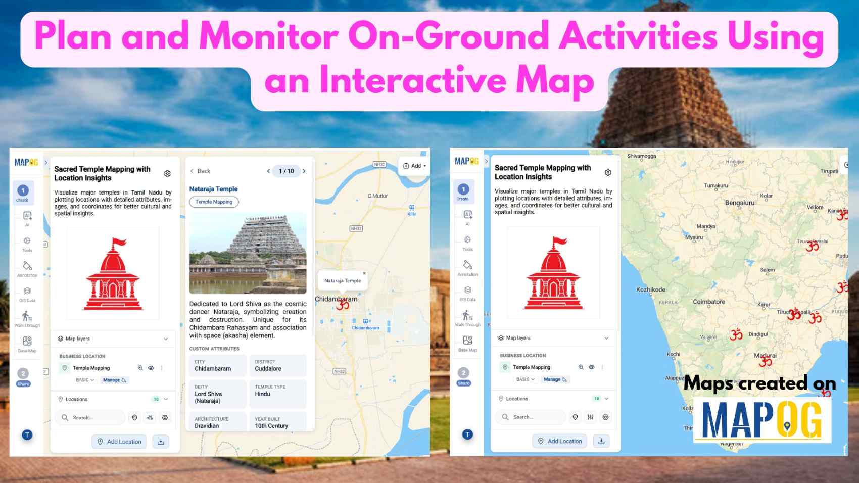
Education

Interactive Population Maps

Interactive Population Map with Heat Bubble and Category Styling

Analysing and interpreting population data across various geographic regions can be done visually with Interactive Population Maps with Heat Bubble and Category Styling. It is simple to quickly identify high and low concentration areas on these maps because they use heat bubbles, which vary in size and colour, to represent population density or totals. Furthermore, … Read more

“Visual map showcasing top universities categorized by popular courses such as MBA, Law, Engineering, and more”

Top Universities on Map by Popular Courses: MBA, Law, Engineering & More

In a globally connected world, students, researchers, and academic planners are increasingly turning to smart solutions for understanding how leading institutions are distributed across regions. Whether you’re exploring top engineering schools, renowned MBA programs, or historic fine arts colleges, mapping education institute places offers a dynamic and visual way to grasp academic reach and reputation. … Read more

Country Wise UNESCO Guide: Top Heritage Spots on a Map

Create Countrywise UNESCO Map: Top Heritage Spots Guide

Create a country-wise UNESCO Guide Map that highlights both cultural brilliance and natural wonders. On the other hand, by integrating GIS tools, this project enhances public awareness, encourages responsible tourism, and supports heritage preservation. It offers users an educational and immersive storytelling experience that makes exploring global heritage sites more accessible, insightful, and engaging. Key … Read more

Top Historical Battles and Their Locations Mapped: How to Share or Embed the Map Anywhere

Top Historical Battles and Their Locations Mapped: How to Share or Embed the Map Anywhere

India, with its deep-rooted civilizational legacy, has witnessed countless turning points in its long and storied past, many of them etched in history through epic battles that shaped empires, cultures, and destinies. From the vast plains of Kurukshetra to the rugged passes of Panipat, the subcontinent has been a stage for conflicts that have defined … Read more

Embedding Maps Boosts Website Engagement: Real Estate Agents

Embedding Maps Boosts Website Engagement: Real Estate Agents

In today’s competitive digital marketplace, real estate agents are increasingly turning to interactive tools to stand out and better serve their clients. One of the most impactful tools in this space is an embedded map. By leveraging Geographic Information Systems (GIS), agents can provide rich, interactive experiences that go far beyond static listings. Through this … Read more

Mapping Noise Pollution Levels in Cities Using Heat Maps and Buffer Tools

Mapping Noise Pollution Levels: Using Heat Maps and Buffer Tools

Noise pollution is an increasingly critical yet often overlooked environmental challenge. In urban areas, it stems primarily from traffic, construction, railways, and industrial activities. Fortunately, with the rise of Geographic Information Systems (GIS) especially tools like heat maps and buffer zones for Mapping Noise Pollution Levels. We can now visualize these invisible pollutants. As a … Read more

Create an Online Map to Visualize and Collaborate on the 7 Wonders of the World

Learn geography & history by creating an interactive map that highlights the 7 Wonders of the World.

Discover geography and history by creating an interactive map of the 7 Wonders of the World—ideal for students, educators, and explorers. These iconic sites highlight human creativity, engineering, and cultural identity, each reflecting the unique legacy of its civilization. Using Geographic Information Systems (GIS), you can combine geography, history, and travel planning into an engaging … Read more

How to create a travel itinerary on a map and share it online

How to Create a Travel Itinerary on a Map and Share It Online

If you’re planning your next big adventure, there’s one thing you shouldn’t skip—how to create a travel itinerary on a map and share it online. It not only helps you stay organized but also allows your friends or travel buddies to follow along in real-time. With intuitive platforms like MAPOG, it’s now easier than ever … Read more

Travel Route Planning Made Simple with Story Maps

Travel Route Planning Made Simple with Story Maps, Story maps are a creative way to integrate storytelling and geographic data, enabling users to see events, experiences, and manage plans on an interactive map combine narrative text, multimedia, and maps to produce a dynamic, captivating format that improves comprehension and sharing. Users can view events, experiences, … Read more

Population Density Map by Districts

How To Create Population Density Map by Districts

Visualizing population density map by districts helps uncover patterns in urban growth, resource distribution, and planning needs. Whether you’re working on development plans, healthcare access, or disaster preparedness, mapping this data by district brings clarity that raw tables cannot. Thanks to MAPOG, users can create, style, and share interactive maps easily—no advanced GIS degree needed. … Read more