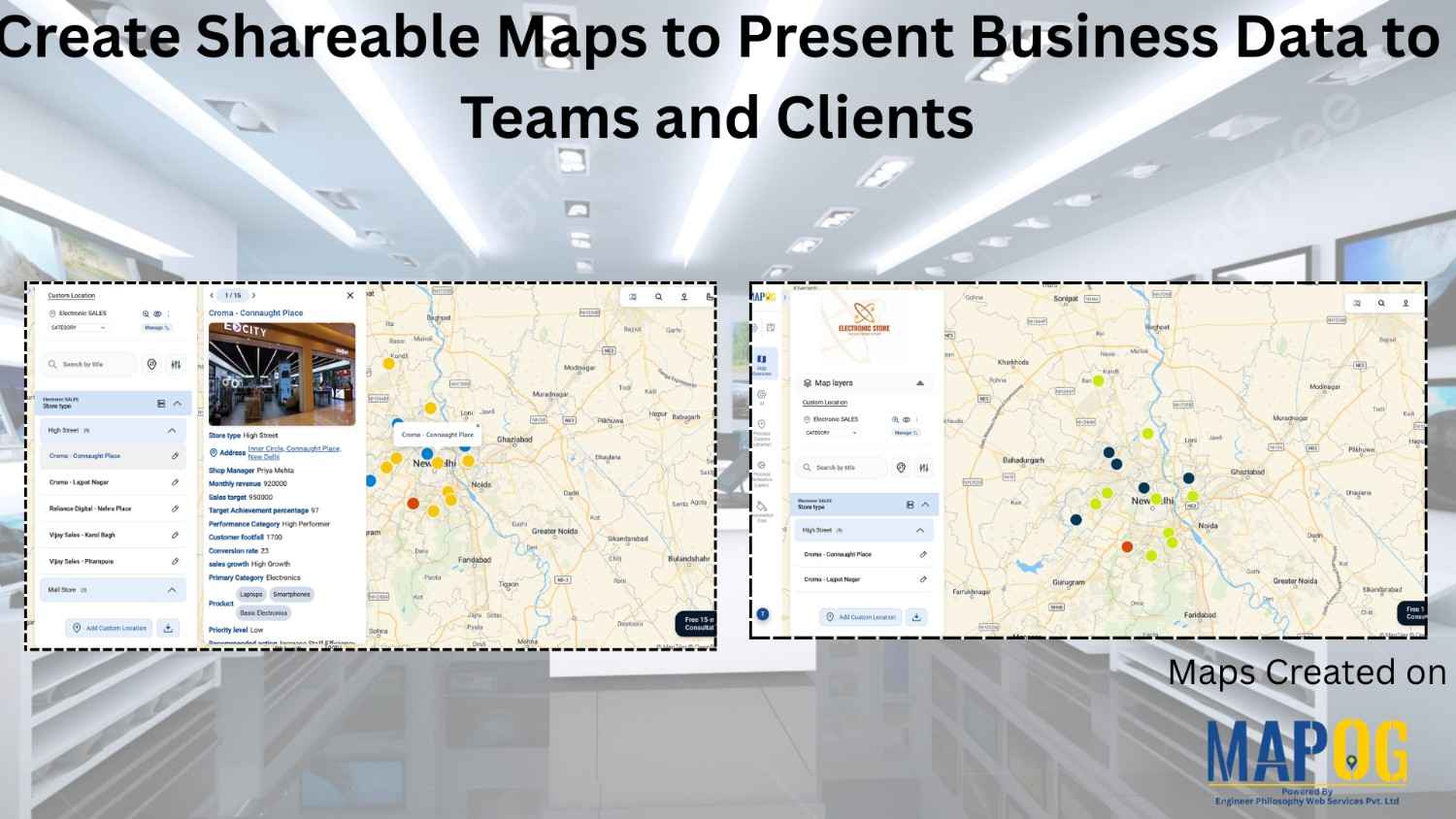
Customer Area

How to Collect Field Survey Data with Photos, Videos, and GPS Location on a Map

How to Collect Field Survey Data with Photos, Videos, and GPS Location on a Map

Traditional field surveys often cause delays, data mismatches, and poor location accuracy. MAPOG simplifies the process by combining field data collection and mapping into one real-time workflow. Key Concept: Collect Field Survey Data with Media & GPS Instead of collecting notes separately and mapping later, MAPOG enables direct data capture on the interactive map. You … Read more

tracking camera installation

Track Installation Locations and Coverage Using an Interactive Map

Camera installation service checks are often managed through spreadsheets, calls, and scattered messages, which leads to confusion about exact track installation locations, delayed updates, and poor visibility into task progress. As a result, technicians may miss follow-ups or revisit sites due to unclear information. However, by using map-based task management in the MAPOG platform, every … Read more

How to Conduct Field Surveys and Store Data on a Map for Analysis

How to Conduct Field Surveys and Store Data on a Map for Analysis

Healthcare systems often face fragmented data and limited visibility, therefore planning and service delivery become challenging. However, MAPOG mobile data collection capability helps teams conduct Healthcare Facility Surveys and analyze accessibility by capturing accurate field surveys and store data in real time, ensuring consistency and enabling faster, data-driven decisions. Key Concepts: Field Surveys and Store … Read more

Manage Site Visits and Client Property Tours on a Single Location Using Task Management

Manage Site Visits and Client Property Tours on a Single Location Using Task Management

Scattered records make it difficult to manage site visits and client property tours in the real estate industry, but MAPOG transforms visit data into a single interactive map. It improves location visibility, coordination, and scheduling while supporting faster decision-making. Track tasks, monitor visits, and ensure accountability using real-world spatial context instead of spreadsheets. Key Concept: … Read more

Plan New Outlet Locations Using Isochrone Analysis for Faster Delivery

Plan New Outlet Locations Using Isochrone Analysis for Faster Delivery

Plan new outlet locations using travel time, not just demand or distance. Travel time, influenced by traffic and road networks, is a more accurate measure. Map delivery-time-based areas using isochrone analysis and visualize them in MAPOG with outlets and demand to identify gaps and plan expansion. Key Concepts for Isochrone Analysis to Plan New Outlet … Read more

How to Track & Manage Interior Design Site Visits on a Map

How to Track & Manage  Interior Design Site Visits on a Map

Interior design teams often struggle with multiple site visits, scattered updates, delayed follow-ups, and low project visibility. When data is spread across tools, coordination slows and decisions take longer. Manage Interior Design Site Visits with MAPOG by bringing all locations, visit status, tasks, timelines, and teams into one clear, interactive map with real-time data, improving … Read more

Digitize a Mall Layout

How to Digitize a Mall Layout on MAPOG for Planning, Construction, and Management

For constructors, real estate developers, architects, planners, and facility managers, digitizing a mall layout is no longer optional; it has become essential for modern mall planning and facility management. When you Digitize a mall layout using MAPOG, you centralize tasks, track updates, and back decisions with real-time location data. Instead of relying on printed blueprints … Read more

How to Collect On-Ground Data Using a Mobile Data Collection App

How to Collect On-Ground Data Using a Mobile Data Collection App

Collecting accurate on-ground data is essential for organizations involved in field surveys, monitoring, inspections and research. Traditional paper-based methods often lead to delays, data loss, and manual errors, limiting timely access to reliable information. Mobile data collection app provides an efficient alternative by enabling real-time data capture, centralized form management, task assignment, and location tracking … Read more

Use “Group By” to Categorize

How to Use “Group By” to Categorize Large Datasets on a Map Easily

Working with large datasets on a map can feel overwhelming when everything appears scattered and unorganized. By using group by to categorize your data by attributes such as state, city, project type, or customer category, you can neatly categorize and organize even the biggest datasets. This simple approach helps your maps become clearer, more manageable, … Read more

visualize the franchise covergae for a bakery outlet

Visualize Franchise Coverage Using Interactive Maps

Running a franchise business is no longer just about opening outlets in multiple cities. Instead, it is about understanding where your outlets are located, how they perform, and which areas remain untapped. This is where interactive maps play a crucial role. Visualize  franchise coverage on a map, businesses can instantly see location patterns, service reach, … Read more