In the frontier of precision agriculture, MAPOG’s Map Analysis tool utilizes cutting-edge technologies to reshape farming practices. Delve into the intricate world beneath the surface, meticulously mapping diverse soil resources using the powerful capabilities of MAPOG. Let the precision of MAPOG guide you through a landscape where informed decision-making harmonizes seamlessly with sustainable farming practices. Join this journey to unravel the potential that MAPOG’s Map Analysis tool offers to farming communities, envisioning a future where strategic mapping and a deep understanding of soil resources play a pivotal role in fostering sustainable and optimized farming practices.
Key Concept
The idea here is that MAPOG‘s Map Analysis tool is like a super helpful guide for farmers. It uses fancy technology to make detailed maps of different types of soil. These maps help farmers make smart decisions for their farms, ensuring they grow crops in a way that’s good for the environment. The concept is about using modern tools to understand the land better, making farming better for everyone. Additionally, MAPOG offers a range of tools such as digitalization, isochrones, route compass, urban planning, merging tools, and environmental protection.
The following steps outline the process of soil mapping
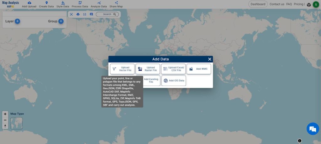
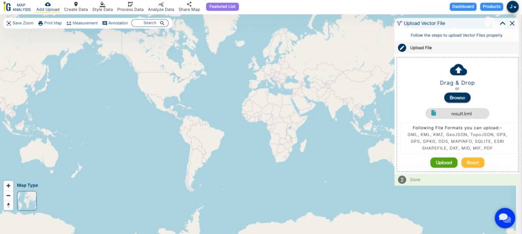
Step 1: Upload Vector File
To initiate the soil mapping process, start by uploading the vector file. Click on “Upload Vector,” then proceed to browse for the soil map file. Complete the process by clicking the “Upload” button.
Step 2: Edit Style
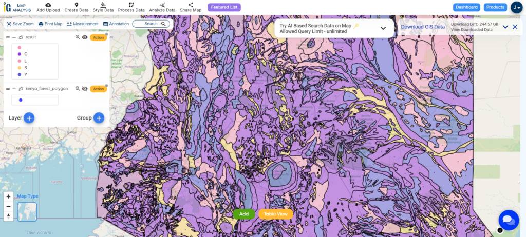
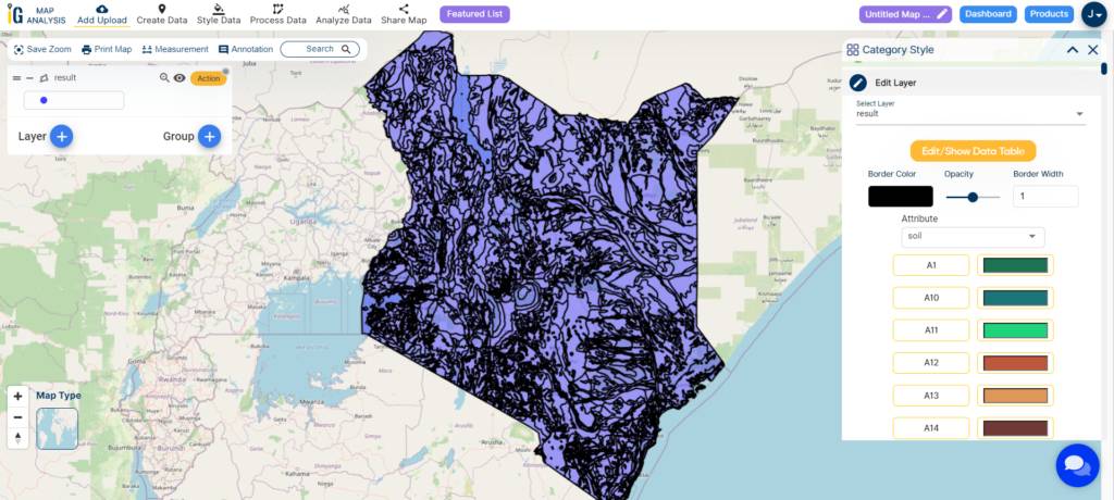
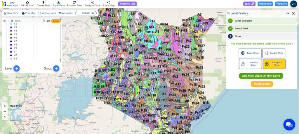
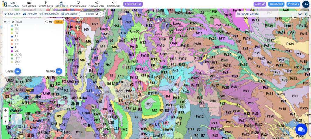
In step two, utilize the “Edit Style” tool to analyze the various soil types. Click on the action button, then choose “Category Style.” Select the layer and set the attribute as “soil,” and finally, save the style.

Step3: Label Feature
In step three, enhance data comprehension by clicking on the action button. Opt for the “Label Feature” option to facilitate a better understanding of the data. After selecting “Label Feature,” choose the attribute “soil” for labelling.
Major Findings
The significant findings of our exploration using MAPOG‘s Map Analysis tool include the powerful ability to create detailed maps of various soil types. This enables farmers to make informed decisions for better agricultural practices. The tool’s precision in mapping diverse soil resources stands out, providing a valuable foundation for sustainable and optimized farming methods. These major discoveries underscore the potential of MAPOG in transforming how we understand and work with the land, particularly in fostering sustainable practices for the benefit of farming communities.
Findings and Future Scope of This Study
The findings and future scope of a study in soil mapping can provide valuable insights into the characteristics and relationships within the soil environment. Here are potential findings and the scope of features that could be explored in such a study:
Findings:
- Soil Classification and Distribution:
- Identification of various soil types and their spatial distribution across the study area.
- Texture and Structure Patterns:
- Mapping of soil texture and structure variations, highlighting patterns that influence water retention, drainage, and overall soil composition.
- Chemical Properties:
- Analysis of soil pH levels, nutrient content, and the presence of essential elements, providing insights into the soil’s fertility.
- Microbial Diversity:
- Exploration of microbial populations in the soil, indicating the diversity and abundance of microorganisms crucial for nutrient cycling.
- Root System Characteristics:
- Assessment of plant root distribution and characteristics, revealing their impact on soil structure and nutrient cycling.
- Topographic Influences:
- Understanding how topographic features such as elevation and slope influence soil development and moisture conditions.
- Climate-Soil Interactions:
- Correlation between climate factors (temperature, precipitation) and soil characteristics, highlighting climate-induced soil variations.
- Land Use and Land Cover Impacts:
- Investigation into how different land uses and land covers affect soil properties, including the impact of agricultural practices and urbanization.
- Geological and Hydrological Features:
- Examination of how geological factors and hydrological features contribute to soil composition and moisture dynamics.
- Spatial Variability:
- Identification of areas with high spatial variability in soil properties, emphasizing the need for site-specific management practices.
Future Scope:
- Precision Agriculture Applications:
- Utilizing findings to enhance precision agriculture practices, including optimized resource management and tailored cultivation techniques.
- Environmental Conservation Strategies:
- Informing strategies for environmental conservation, especially in areas prone to erosion, nutrient depletion, or other soil-related challenges.
- Land Use Planning and Zoning:
- Providing data for informed land-use planning and zoning decisions based on soil suitability for different purposes.
- Biodiversity Conservation Initiatives:
- Supporting initiatives for biodiversity conservation by identifying areas with unique soil characteristics crucial for diverse ecosystems.
- Disaster Preparedness and Mitigation:
- Contributing to disaster preparedness and mitigation efforts by identifying areas prone to soil-related disasters like landslides or floods.
- Infrastructure Development Considerations:
- Guiding infrastructure development by assessing soil stability and suitability for construction projects.
- Climate-Resilient Agriculture:
- Supporting the development of climate-resilient agricultural practices by understanding the correlation between climate and soil properties.
- Educational and Outreach Programs:
- Facilitating educational programs and outreach initiatives to disseminate knowledge about soil health and sustainable practices.
The study contributes to sustainable land management, resource optimization, and informed decision-making in various sectors by integrating these findings and features into practical applications
Domain and Industry
- Agriculture
- Precision Agriculture
- Geographic Information Systems (GIS)
- Environmental Sustainability
- Land Management
- Farming Practices
- Soil Analysis
- Agricultural Technology
Conclusion
In conclusion, MAPOG‘s Map Analysis tool proves invaluable for modern agriculture, offering detailed soil maps that empower farmers to make informed decisions, promoting sustainable and optimized farming practices. The precision and insights provided by MAPOG have the potential to revolutionize land management, ensuring a more sustainable future for farming communities. As we unlock the capabilities of this innovative tool, the path forward involves embracing technology to enhance our understanding of the land and promote responsible agricultural practices. For further inquiries, contact us at support@mapog.com.