In the realm of urban planning and transportation, the digitalization of geographical data has become paramount. Focusing on road networks, this article delves into the transformative power of the MAPOG Map Analysis Tool. Leveraging OpenStreetMap as a base, we explore the efficiency and precision gained through creating line data for roads. Join us in unraveling the potential of digitalization in reshaping urban mobility and infrastructure planning.

Key Concept
The key concept revolves around the pivotal role of the MAPOG Map Analysis Tool in digitally transforming road networks. By harnessing OpenStreetMap as the foundational base, this process involves creating accurate line data for roads. The implications are far-reaching, promising enhanced efficiency in urban mobility, informed traffic management, and strategic infrastructure planning through the lens of advanced geospatial analysis.
Moreover, MAPOG goes beyond mere road mapping capabilities. It equips users with tools to create point, line, and polygon features, broadening its utility and enabling comprehensive geospatial analysis across various domains. With MAPOG, the potential for innovation and optimization within urban and rural landscapes is truly boundless.
Step-by-Step Road Digitalization Guide
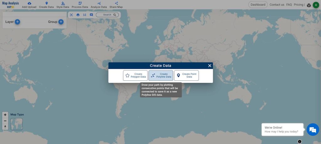
Step 1: Launch Map Analysis Tool and Choose “Create Data”
Begin your road digitalization journey by opening the Map Analysis Tool. Within the interface, opt for the “Create Data” feature to initiate the process. This step lays the foundation for transforming geographical information into a digital format.
Step 2: Choose “Create Polyline Data” within the Create Data Menu
Within the Create Data menu, specifically select the “Create Polyline Data” tool. This crucial step directs the focus towards establishing precise linear representations of roads, setting the stage for meticulous digitalization.
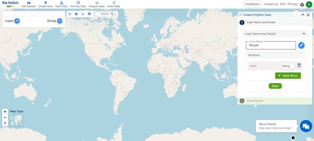
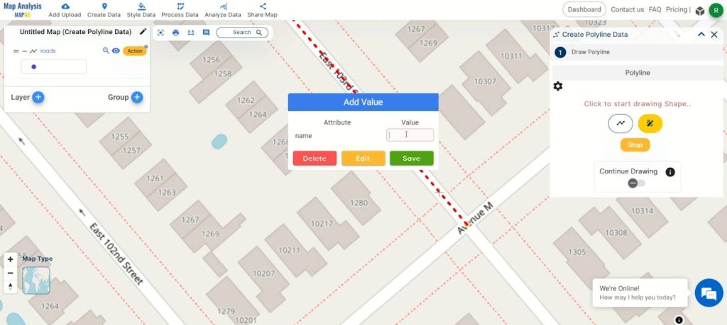
Step 3: Rename Layer, Update Attribute Table, and Begin Digitalizing Roads
After selecting “Create Polyline Data,” proceed by renaming the layer to ‘Road’ for clarity. Customize the attribute table according to your specific requirements. Once satisfied, click ‘Save.’ Navigate to the next tab, where you’ll find a pencil icon. Click on it to initiate the digitalization process for roads, marking a pivotal step in refining and enhancing geographical data.
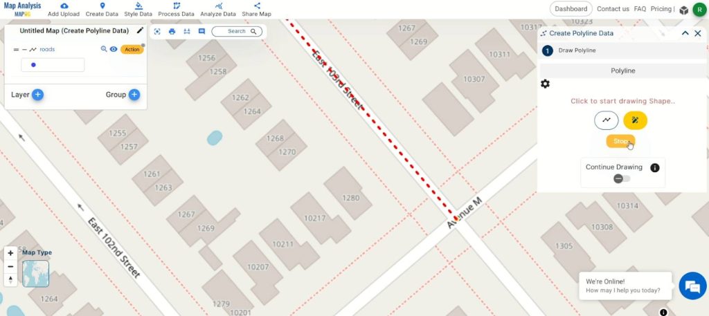
Step 4: Complete Drawing, Click Stop, and Update Attribute
Once you’ve drawn the line representing the road, click on the ‘Stop’ button to finalize the digitalization process. Next, update the attribute with the name of the created line. Confirm your changes by clicking ‘Save.’ This step ensures accurate and detailed information is associated with the digitally drawn road, contributing to a comprehensive and well-defined dataset.
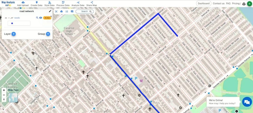
Step 5: Rename and Save the Project
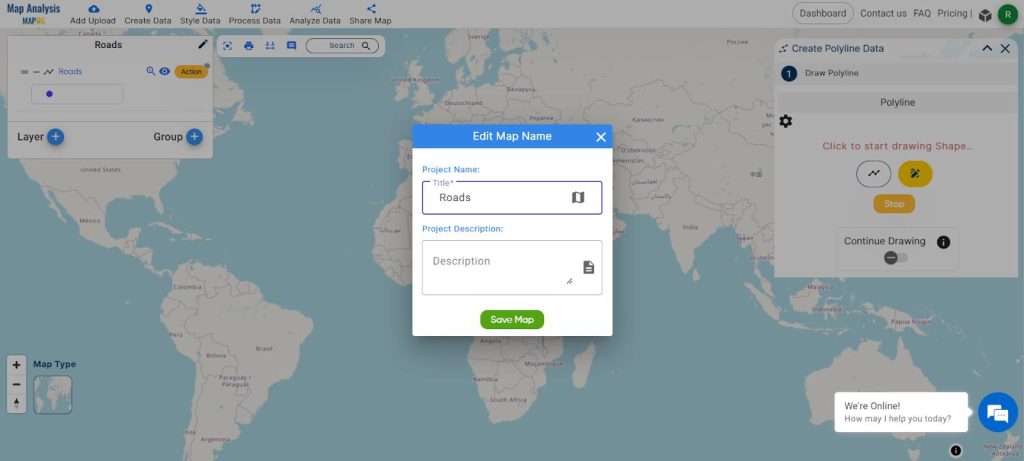
To organize your project efficiently, rename the map by clicking the pencil icon in the top right corner of the left-hand side box. Enter a suitable name for the map and then select “Save Map” to apply the changes. This final step ensures that your digitalized road data is stored systematically, making it easily accessible and identifiable for future reference.
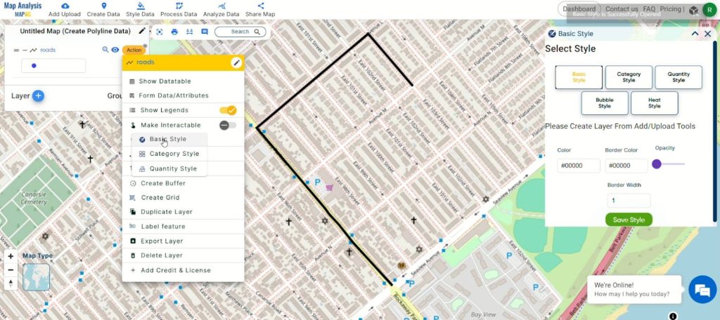
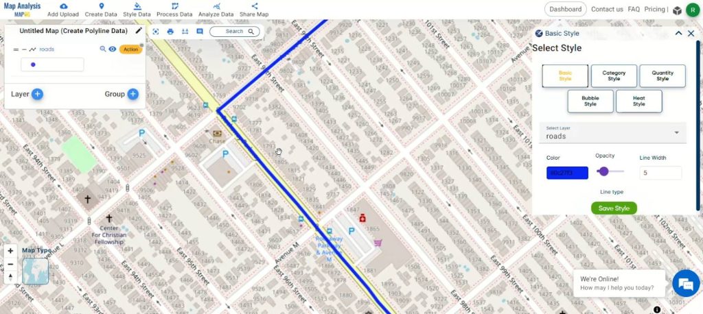
Step 6: Choosing a Basic Style for Visual Customization
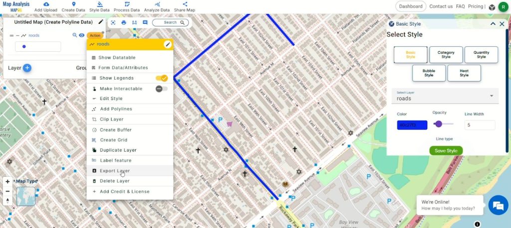
Refine your digitalization project by customizing the visual representation of your datasets. Click the action button and select ‘Edit Style,’ then opt for the ‘Basic Style’ to tailor the appearance of your digitalized road data according to your preferences. This step ensures a personalized and clear presentation, enhancing the overall visual impact of your mapped information.
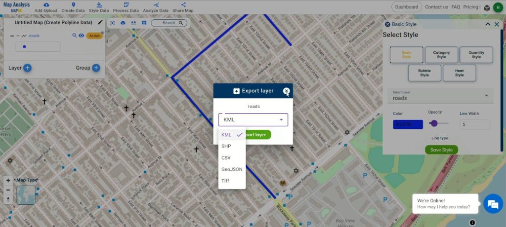
Step 7: Exporting the Digitalized Road Data
To share or utilize your digitalized road data, click on the action button. From the options presented, select “Export Layer” to access a variety of export formats. Choose the desired format for seamless integration with different applications or analysis tools. This step broadens the utility of your digitalized road information, allowing for diverse applications in the realm of geospatial analysis.
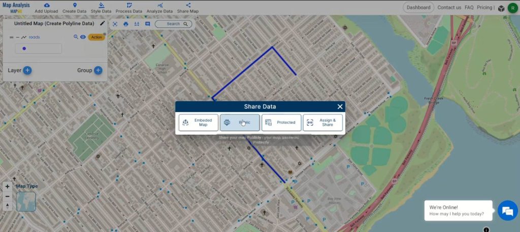
Step 8: Sharing the map
To share the map, click on the Share Map.
Major Findings
Upon navigating the step-by-step process of digitalizing roads using the MAPOG Map Analysis Tool, several noteworthy discoveries emerge. The tool not only streamlines the conversion of geographical features into digital formats but also offers a user-friendly interface for creating and refining polyline data. Renaming layers, updating attribute tables, and exporting data in various formats enhance the tool’s versatility. The seamless integration with OpenStreetMap and the ease of project management through renaming and saving contribute to an efficient and comprehensive road digitalization workflow. These major findings collectively underscore the MAPOG Map Analysis Tool‘s significance in advancing precision and efficacy in the domain of geospatial data management.
Domains and Industries Benefiting
- Urban Planning: Optimizes transportation infrastructure planning.
- Civil Engineering: Enhances precision in road design for safer and more efficient traffic flow.
- Geographic Information Systems (GIS): Streamlines data management with integration into GIS workflows.
- Environmental Monitoring: Facilitates accurate road data for ecological impact assessments.
- Emergency Services: Improves decision-making for emergency response.
- Logistics: Enhances route planning and logistics efficiency.
- Smart City Initiatives: Contributes to data-driven decision-making for smart city development.
Conclusion
In conclusion, the MAPOG Map Analysis Tool emerges as a pivotal force in digitally transforming road networks, proving indispensable across diverse domains and industries. The step-by-step guide unveils its capacity to convert geographical data into precise, actionable insights, enhancing efficiency in urban planning, civil engineering, GIS, and beyond. The major findings highlight its significance in data management, project efficiency, and informed decision-making.
As we navigate through applications in environmental monitoring, emergency services, logistics, and smart city initiatives, MAPOG proves to be a versatile asset, contributing to progress in various sectors. For further inquiries and support, you can reach out to support@mapog.com, solidifying MAPOG not just as a technological solution but as a catalyst for innovation and data-driven advancements in the dynamic landscape of digital road infrastructure.
Other Articles
- Protecting Wetlands: Guide to Create GIS Map for Nature
- GIS Analysis in Urban Planning: Reshaping Transportation Future Insights of state/city
- Fast Emergency Response: Using GIS and Isochrone Maps for 10-Minute Ambulance Arrival
- Mapping Tiger Attack Hotspots – Create an Online Map and Share
- Make Routes for Military Aerial Planning- Through Bearing angle and Distance calculation – Online Route Compass
- Mapping Healthcare Efficiency: GIS Buffer Analysis of Hospital Locations
- Add WMS- Two step online view of WMS layer on a map
- Plot ATM locations on a map and embed on your website
- Map habitat locations of endangered animals & keep track of their living
- Create Map on Literacy Rate
- Create Map – DIGITIZING SOLAR, HYDROELECTRIC, WIND AND BIOMASS POWER PLANTS – RENEWABLE ENERGY
- Create a Map to find suitable sites for constructing a new house
- Create Map for Analyzing Water Quality using Heat Map Style
- Create Map – School Map Area Coverage Through Buffer Analysis
- Mapping Safety Create GIS Map : Game-Changing Approach to Hospital Risk Analysis
- Create Map for Real Estate Developer for Best Site Selection
- Create Map for Landfill Optimization: Spatial Analysis Approach
- Create Off-Road Hiking Routes: Using Bearing Angles and Distances
- Creating Safe Routes for Armies and Rescue Teams