Navigating through critical routes with unparalleled precision is a paramount requirement for armies and rescue teams. In the realm of advanced navigation tools, the “Creating Safe Routes for Armies and Rescue Teams” solution, powered by the MAPOG Route Compass, emerges as a beacon, revolutionizing the approach towards route planning. This article delves into the essence of the advanced navigation tool, here we are create route map at high altitudes.
Key Concept to Creating Safe Routes for Armies and Rescue Teams
Empowering military and rescue operations, the advanced navigation tool, MAPOG Route Compass, optimizes route planning with unparalleled precision. Its innovative features enhance the effectiveness of tactical teams, providing crucial guidance on critical routes. This transformative solution revolutionizes traditional approaches, ensuring strategic advantages for armies and swift response capabilities for rescue teams in dynamic and challenging environments. To delve deeper into the interconnected world of cutting-edge navigation tools, explore our recent blog on “Make Routes for Military Aerial Planning- Through Bearing angle and Distance calculation – Online Route Compass”, shedding additional light on the evolving landscape of navigation solutions. Unlocking the power of MAPOG Route Compass for advanced route analysis becomes even more insightful when viewed in conjunction with the advancements discussed in this companion piece.
Create route map at high altitudes through MAPOG
Unlocking the power of our advanced navigation tool for armies and rescue teams is easy with a simple step-by-step process. Let’s consider an example where we create a road:
Step1: Initiating the Journey:
Start by setting the route’s origin, such as the bustling city. MAPOG Route Compass allows for seamless waypoint plotting.
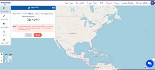
- Click on the “Add Point” button and choose the option “Search Address”.
- Here you have to search the address.
Step2: Waypoint Mastery:
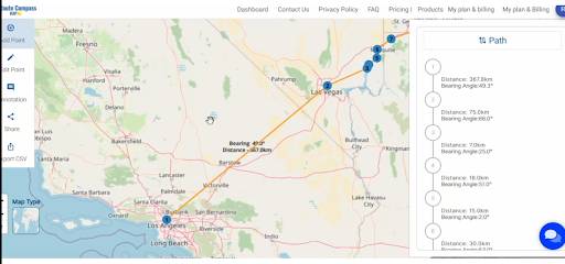
Progress to key waypoints and witness the tool’s prowess in area searches. This step is crucial for comprehensive route planning, especially in diverse terrains.
Step 3: Searching and Plotting Distances:
Employ the area search feature to explore the surroundings interactively. Simultaneously, witness the tool’s capability to calculate real-time distances between waypoints, a valuable asset for tactical navigation.
- Click on the “Add Point” button and choose “Dist-Angle Value”.
- Now plot the Distance and Bearing angle for each point.

Step 4: Determining Bearing Angles:
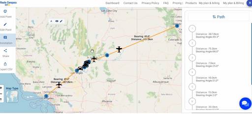
Delve into the world of bearing angles as MAPOG Route Compass effortlessly calculates the directional aspects between waypoints. This feature adds a layer of precision crucial for strategic navigation.
You can see the distances and bearing angles are shown on the right side of your screen.
Step 5: Final Destination:
Conclude the journey by setting the endpoint. MAPOG Route Compass completes the route map, providing a comprehensive visualization of the entire journey. now search the address and plot the end point.
- click on the “Add Point” button and choose the option “Search Address”.
- here you have to search the address.
Major Findings:
- The MAPOG Route Compass works well in challenging areas like hills and rivers, helping teams navigate smoothly.
- The tool is really good at helping teams move through hilly areas without any problems.
- It’s great at making sure teams can easily cross rivers by finding the best routes.
- The MAPOG Route Compass can deal with different landscapes, like forests or open areas, making it useful in any environment.
- It’s good at dealing with the tricky parts of missions, making sure teams can find their way even in tough situations.
Beneficial Domain: Armies and Rescue Units:
For armies and rescue units, MAPOG Route Compass emerges as an invaluable asset. Its precision in route planning, including distance calculations and bearing angles, enhances operational efficiency. The tool’s ability to navigate challenging terrains is a strategic advantage, optimizing journeys and contributing to the success of critical operations.
The MAPOG Route Compass stands as a game-changer in precision navigation for tactical teams, providing essential features like waypoint plotting, distance calculations, and bearing angle determinations. For any queries, reach out to us at support@mapog.com to ensure seamless support and further enhance your navigation experience.
Exploring Our Previous Blogs:
- GIS Analysis in Urban Planning: Reshaping Transportation Future Insights of state/city
- Make Routes for Military Aerial Planning- Through Bearing angle and Distance calculation – Online Route Compass
- Protecting Wetlands: Guide to Create GIS Map for Nature
- Create Marathon Route Navigation Map – With Bearing and Distance
- Plotting Airports on MAP: Simplifying Logistics and Planning
- Create Off-Road Hiking Routes: Using Bearing Angles and Distances
2 thoughts on “Creating Safe Routes for Armies and Rescue Teams”