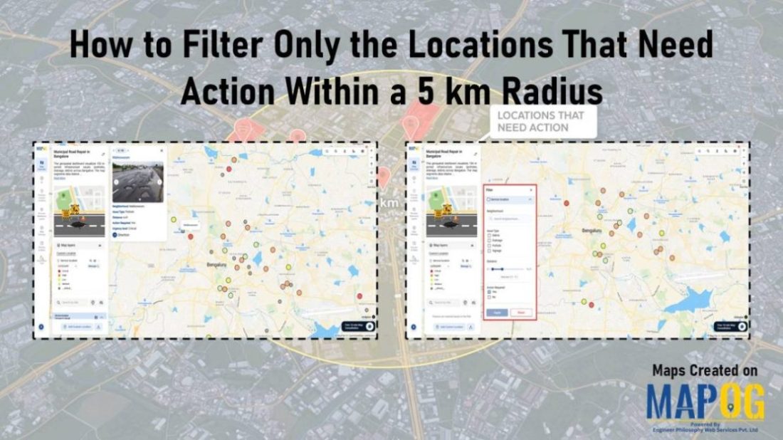
Road

Track Task Progress on a Map

Track Task Progress on a Map Dashboard (Completed vs Pending)

Tracking everyday projects on spreadsheets often turns messy, especially when tasks spread across different teams and locations. Instead of flipping through endless reports, a smarter way is to track task progress visually on a map dashboard. This approach gives you an instant view of what’s done and what’s pending while also keeping everything more organized. … Read more

Measure Distance & Area on a Map (Free Online Tool)

Measure Distance & Area on a Map (Free Online Tool)

Measuring distance and area is a fundamental tool with a wide range of applications like calculating land parcels, determining the lengths of roads and rivers. Leveraging MAPOG one can measure distance and area enabling to analyze and manage geospatial data for more informed and efficient decision making. Key concept and importance The key concept of … Read more

Smart Hiking Trail Planning Visualize Bearings, Distances, and Key Checkpoints

Smart Hiking Trail Planning: Visualize Bearings, Distances, and Key Checkpoints

As outdoor enthusiasts seek more rewarding and safe adventures, Smart Hiking Trail Planning goes beyond simply picking a path—it’s about understanding the bearings, distances, and key checkpoints along the journey through interactive mapping. Hikers often struggle to gauge accurate directions, track distances between waypoints, or identify important rest spots and landmarks. Without Smart Hiking Trail … Read more

How to Create a Safari Itinerary Map for Your Trip

Create & Share a Safari Itinerary Map for Your Trip

If you’re planning a safari, visualizing your journey on a map can turn your travel plans into an interactive and shareable experience. From visiting to all safari locations and back, mapping your safari helps you track routes, highlight wildlife hotspots, and organize activities. Using MAPOG, you can create a rich safari itinerary map that’s engaging, … Read more

Mapping Coastline Marathon with GIS

How to Use GIS for Coastline Marathon Route Mapping and Logistics

Mapping Coastline Marathon organizing a marathon along coastline requires accurate GIS mapping . By plotting hydration points, medical tents, and key milestones, planner, smooth logistics, and a great runner experience without complex crowd-flow simulations, using interactive maps with coastline and checkpoint data. Key Concept: Mapping Coastline Marathon Identifies: Uses of Mapping Coastline Marathon Methodology: Mapping … Read more

Urban Flood Hotspots Mapping

Create Map for Urban Flood Complaint Hotspots and Shelter Accessibility 

In today’s rapidly growing cities, climate change and infrastructure weaknesses have made urban flooding a significant challenge for communities and city planners alike. During heavy rain or storms, certain areas become prone to waterlogging, flood risks, and complaints, putting nearby properties and people at risk. At the same time, identifying high-risk zones and nearby shelters—and … Read more

How GIS on Map Helps Optimize Public Transport Routes and Reduce Traffic

In today’s urban landscape, GIS for public transport optimisation is basically transforming how cities tackle congestion and improve mobility. By integrating spatial data with transit planning altogether, Geographic Information Systems help planners design smarter, more efficient transport routes that reduce traffic, improve accessibility, and enhance commuter satisfaction. Understanding GIS for Public Transport Optimization and Why … Read more

GIS Mapping of Landslide

GIS Mapping of Landslide-Prone Villages and Road Accessibility

In recent years, the importance of GIS Mapping of Landslide-prone areas has grown significantly. As climate conditions continue to worsen and extreme weather becomes more frequent, it is becoming increasingly critical to assess not only the vulnerable zones but also how surrounding communities and nearby roads can be affected. Consequently, this blog will walk you … Read more