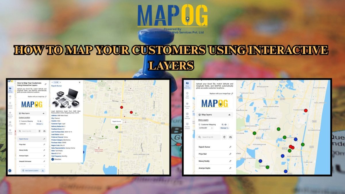
Easy Map Creation

Change Map Icons & Sizes Based on Your Data Values

Often, when faced with a large set of data, it is very difficult to visualize it together. We need the help of data visualization tool in digital maps. Suppose you are a businessperson, who owns several retail chain stores across the city and need to see the performance of your stores in an effective manner. … Read more

Share an Interactive Map with Teammates (View or Edit Access)

Best Way to Share Interactive Maps Online with View and Edit Access

Today, readers and team members expect more than just static information when exploring content or managing data online. Whether it’s tracking locations, updating details, or monitoring progress, interactive maps make collaboration simple and engaging. With MAPOG, you can easily share an Interactive Map with teammates, assigning view or edit access to ensure the right people … Read more

How to Map Drainage Points & Stormwater Drains for Smarter Urban Maintenance

How to Map Drainage Points & Stormwater Drains for Smarter Urban Maintenance

To Map Drainage Points effectively is one of the most critical parts of urban infrastructure, since clogged or damaged drains often remain unnoticed until monsoons cause flooding. For example, during heavy rains, municipal teams in many cities spend hours locating hidden or encroached drains before cleaning begins—by then, water logging has already disrupted traffic and … Read more

Edit and Update Point Information After Uploading Data

Edit and Update Map Data for Fire Safety and Infrastructure Projects

When managing urban infrastructure projects, uploading data to a map is only the beginning. The real value emerges when teams can edit and update point information after uploading data seamlessly. For example, a fire safety company that installs alarms every month needs to keep its records accurate and current. While uploading installation data offers an … Read more

Draw & Style Property Boundary Polygons on a Map

Draw & Style Property Boundary Polygons on a Map

With the help of GIS, professionals Draw and Style Property Boundary Maps to visualise, manage, and analyze land ownership clearly and efficiently. Whether you are a city planner, a surveyor, a real estate professional, or simply someone trying to understand land parcels in your community, drawing and styling property boundary mapping with GIS includes polygons … Read more

How to Map Water ATMs and Community Taps for Equitable Access to Clean Drinking Water.

Mapping Water ATMs and Community Taps for Equitable Access to Clean Drinking Water

Indeed Access to safe drinking water is firstly a basic human right, however many underserved neighborhoods for instance still face challenges in finding electric stations and  clean water sources. Thus how to map Water ATMs and community taps using MAPOG provides a comparable data-driven solution in like manner to visualize access gaps and plan interventions. … Read more

Famous Alumni Map Discover Notable Personalities and Their Universities

Famous Alumni Map: Showcase Notable University Graduates, Achievements & Success Stories

Universities are the birthplaces of leaders, innovators, and change makers. Mapping notable alumni with MAPOG showcases their achievements, highlights global impact, and inspires future generations by tracing where their journeys began through a famous alumni map. Key Concepts: Why Create a Famous Alumni Map? Alumni achievements are often scattered, but a digital map highlights them … Read more

Fire Station Mapping: How GIS Fire Safety Maps Improve Emergency Response & Community Safety

Fire station mapping is an important step as fires spread fast, and when communities lack nearby fire stations, hydrants, or safety infrastructure, the risk of damage rises dramatically. That’s why mapping fire safety infrastructure has become an essential tool for city planners, emergency responders, and local authorities. furthermore using GIS-based interactive tools like MAPOG to … Read more

Mapping Public Amenities to Spot Underserved Areas and Plan New Developments

Public Amenities Mapping with GIS: How Cities Can Improve Schools, Hospitals, Parks & Community Services

Mapping Public Amenities to transform your city into a granted transparent, inclusive, and well-planned urban space with GIS-powered public amenity mapping. This modern approach enables governments, planners, and communities to visualize essential services such as schools, hospitals, parks, libraries, and more on a single interactive map. By identifying underserved areas as much as cities can … Read more

How Mapping Community Water, Energy and Environmental Projects Can Drive Sustainable Development

How Interactive Maps Drive Community Water, Energy, and Environmental Projects

Sustainable development cannot be achieved without community-driven initiatives that focus on water, energy, and environmental needs. Moreover, Mapping Community Water, energy, and environmental projects offers a practical way to visualise data, highlight impact, and ensure transparency. In fact, by creating interactive maps, decision-makers, NGOs, and local communities can track project status, monitor beneficiaries, and share … Read more