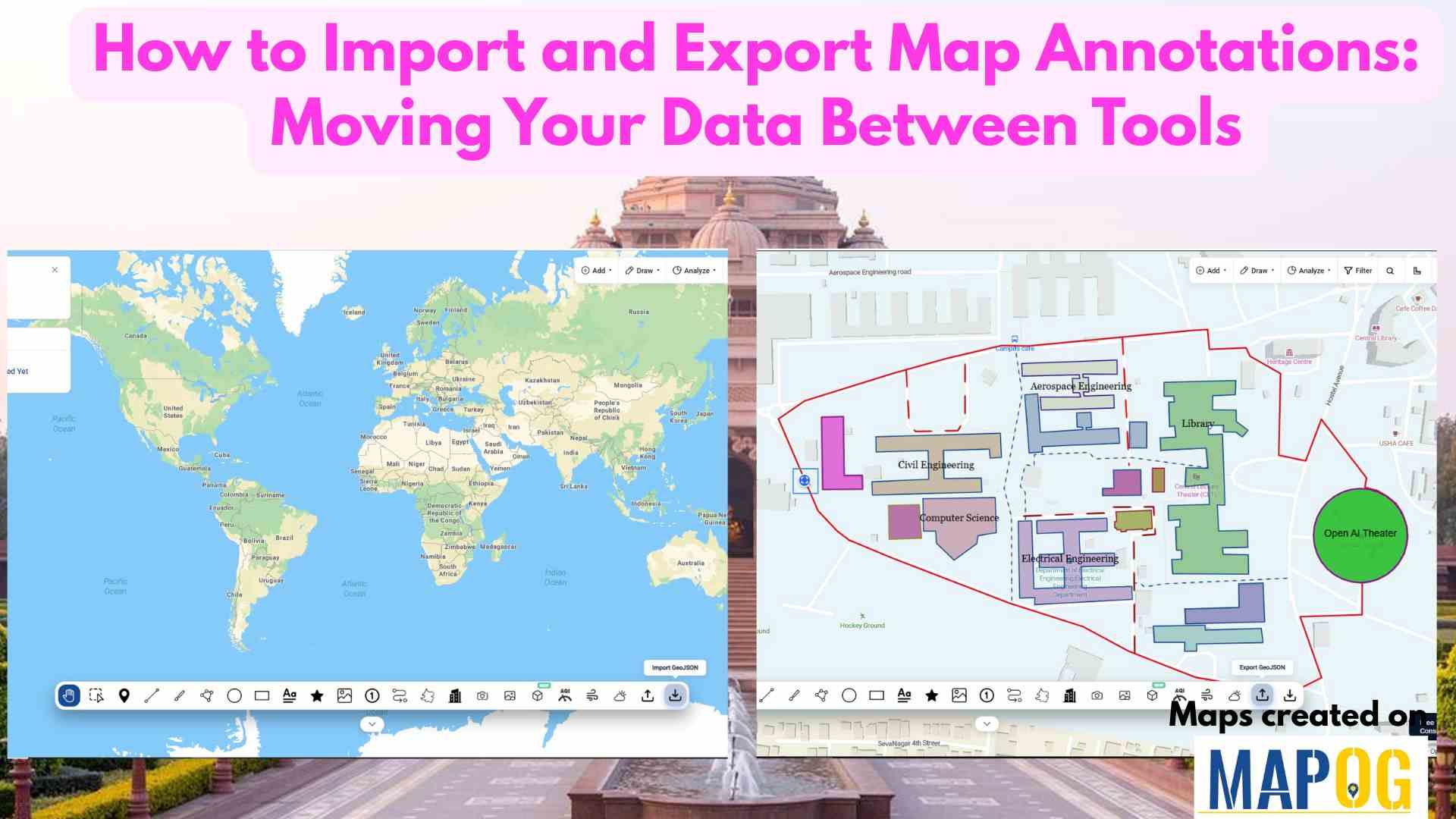
Education

Download Your Mapped Data in Different Formats

Download Your Mapped Data in Different Formats

Interactive maps do more than just visualize locations—they also store valuable data that can be exported, shared, and analyzed across multiple platforms. For instance, whether you’re tracking coffee shops, field points, real estate listings, or even survey data. MAPOG lets you download your mapped data layers in formats like CSV, XLS, JPG, KML, or SHP. … Read more

5 Inspiring Examples of Interactive Dynamic Maps You Can Create Online

Interactive and dynamic maps not only transform data into actionable visuals but also let users explore, interpret, and share insights. With MAPOG, you can not only map portfolios, campuses, routes, or stores but also organize, analyze, and visualize trends; moreover, this enables clearer, faster, and connected decisions. Key Concept: Why Create Interactive Dynamic Maps? Interactive … Read more

Manage and Share Location-Based Projects Online with an All-in-One Mapping Tool

In today’s fast-paced project environments, tracking multiple sites, teams, and resources across locations is a major challenge. Therefore, to manage and share location-based projects, and moreover to help construction managers track distributed sites, project mapping now provides an all-in-one solution. With MAPOG, even a simple Excel sheet can quickly transform into an interactive map; as … Read more

Attach Files Links & Images

Attach Files, Links & Images to Map Pins – History Map

Attach files, links, and images to map pins is what transforms a simple map into an interactive storytelling tool. Instead of limiting a pin to just coordinates and a title, you can enrich it with supporting documents, external references, or photographs with MAPOG. This makes maps not only visually engaging but also more useful—whether for … Read more

Mapping Platform vs Traditional Maps

Mapping Platform vs Traditional Maps: Everything You Need to Know

In today’s world, mapping platform vs traditional maps is a common debate, meanwhile where technology drives nearly every decision, the way we view and use maps has transformed dramatically. Historically, traditional maps once served as our primary guides offering static representations of geography, routes, and landmarks. However, with the rise of modern mapping platforms like … Read more

How to Sort Map Locations by Distance from Your Current Location

In today’s fast-paced, location-driven world, knowing exactly where things are in relation to you is essential. Whether it’s finding the nearest hospital during an emergency, locating a petrol pump while traveling, or discovering nearby restaurants and stores, thus being able to sort map locations by distance from your current location can save significant time and … Read more

How to Add POIs to Property Maps to Make Listings More Attractive

In today’s competitive real estate market, presentation is everything. Buyers and investors don’t just want to see where a property is—they want to understand what surrounds it. Adding Points of Interest (POIs) such as schools, restaurants, parks, hospitals, and transit hubs transforms simple property maps into a powerful storytelling tool. It helps viewers visualize lifestyle, … Read more

5 Essential Features Every Interactive Map Should Have

Interactive maps for tourism planning transforms raw data into dynamic visuals, helping manage tourism efficiently. Additionally, the 5 essential features every interactive map should have are Real-World Updates, Custom Icons & Labels, Heatmaps, Pop-Ups and Collaboration. Key Concept: interactive maps for tourism planning Interactive maps highlight attractions, heritage sites, hotels, and amenities while integrating layers like … Read more

Draw 3D Building Models Online – Interactive Map Tutorial for Urban Planners & Developers

As cities evolve into smarter, data-driven ecosystems, interactive 3D building visualizations are transforming the way we explore and understand urban spaces, and learning how to draw 3D buildings has become an essential skill in this transformation. Whether used for dynamic urban planning, immersive real estate showcases, or engaging educational projects, 3D models turn ordinary maps … Read more

Color-Code Map Points by Category (Online, No-Code)

To begin with, Color-Code Map Points is a simple yet powerful way to transform raw data into clear, visual insights. Moreover, this approach enables governments, planners, and communities to classify projects, services, or assets into instantly understandable categories on a single interactive map. As a result, we can instantly track and visualize metro stations in … Read more