Juhi

Digitize a Mall Layout

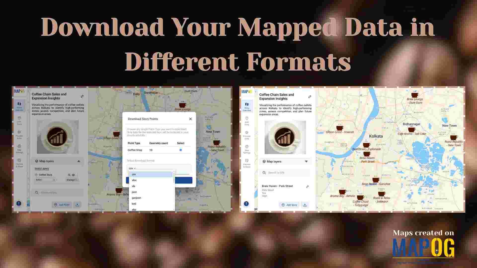
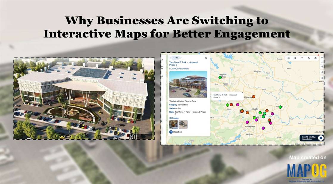
How to Digitize a Mall Layout on MAPOG for Planning, Construction, and Management

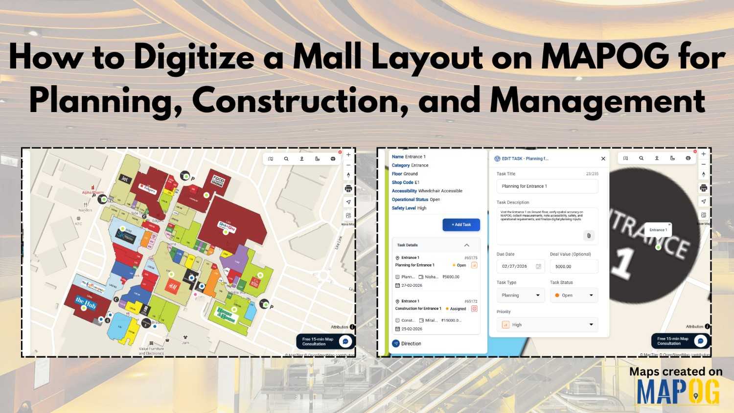
For constructors, real estate developers, architects, planners, and facility managers, digitizing a mall layout is no longer optional; it has become essential for modern mall planning and facility management. When you Digitize a mall layout using MAPOG, you centralize tasks, track updates, and back decisions with real-time location data. Instead of relying on printed blueprints … Read more

Download Your Mapped Data in Different Formats

Download Your Mapped Data in Different Formats

Interactive maps do more than just visualize locations—they also store valuable data that can be exported, shared, and analyzed across multiple platforms. For instance, whether you’re tracking coffee shops, field points, real estate listings, or even survey data. MAPOG lets you download your mapped data layers in formats like CSV, XLS, JPG, KML, or SHP. … Read more

Why Every Business Needs a Visual Map, Not Just a Dashboard

Why Every Business Needs a Visual Map, Not Just a Dashboard

Dashboards summarize numbers, but visual maps reveal where and why things happen. Business Needs a Visual Map for example, a coffee chain can use MAPOG to see café locations, spot top performers, and analyze competitor proximity in one interactive platform. Moreover, visual maps also help real estate, logistics, healthcare, and many other industries turn complex … Read more

5 Inspiring Examples of Interactive Dynamic Maps You Can Create Online

Interactive and dynamic maps not only transform data into actionable visuals but also let users explore, interpret, and share insights. With MAPOG, you can not only map portfolios, campuses, routes, or stores but also organize, analyze, and visualize trends; moreover, this enables clearer, faster, and connected decisions. Key Concept: Why Create Interactive Dynamic Maps? Interactive … Read more

Manage and Share Location-Based Projects Online with an All-in-One Mapping Tool

In today’s fast-paced project environments, tracking multiple sites, teams, and resources across locations is a major challenge. Therefore, to manage and share location-based projects, and moreover to help construction managers track distributed sites, project mapping now provides an all-in-one solution. With MAPOG, even a simple Excel sheet can quickly transform into an interactive map; as … Read more

Learn how to build mobile-friendly web maps quickly and easily using MAPOG for responsive, interactive mapping.

How to Build Mobile Web Maps Quickly and Easily

In the era of smartphones, build mobile web maps has become essential for real-time navigation, planning, and communication. Traditional GIS software can be complex and desktop-oriented, but MAPOG makes it simple to build fully responsive, mobile-friendly interactive maps without coding. From visualizing city infrastructure to projects like “Showcase Your Hotel with an Interactive Property Map for … Read more

Interactive Maps for Better Engagement

Why Businesses Are Switching to Interactive Maps for Better Engagement

Businesses today are moving beyond static visuals and lengthy reports — they’re using interactive maps for better engagement to turn raw data into visual stories. From real estate firms displaying project portfolios to tourism companies mapping destinations, and logistics brands tracking operations, interactive mapping platforms like MAPOG are helping businesses communicate more effectively and engage … Read more

Attach Files Links & Images

Attach Files, Links & Images to Map Pins – History Map

Attach files, links, and images to map pins is what transforms a simple map into an interactive storytelling tool. Instead of limiting a pin to just coordinates and a title, you can enrich it with supporting documents, external references, or photographs with MAPOG. This makes maps not only visually engaging but also more useful—whether for … Read more

Share an Interactive Map with Teammates (View or Edit Access)

Best Way to Share Interactive Maps Online with View and Edit Access

Today, readers and team members expect more than just static information when exploring content or managing data online. Whether it’s tracking locations, updating details, or monitoring progress, interactive maps make collaboration simple and engaging. With MAPOG, you can easily share an Interactive Map with teammates, assigning view or edit access to ensure the right people … Read more

How to Map Drainage Points & Stormwater Drains for Smarter Urban Maintenance

How to Map Drainage Points & Stormwater Drains for Smarter Urban Maintenance

To Map Drainage Points effectively is one of the most critical parts of urban infrastructure, since clogged or damaged drains often remain unnoticed until monsoons cause flooding. For example, during heavy rains, municipal teams in many cities spend hours locating hidden or encroached drains before cleaning begins—by then, water logging has already disrupted traffic and … Read more