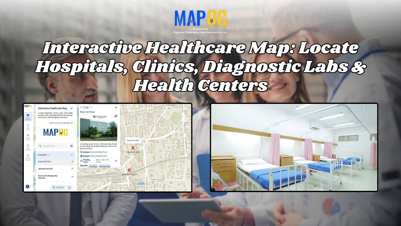
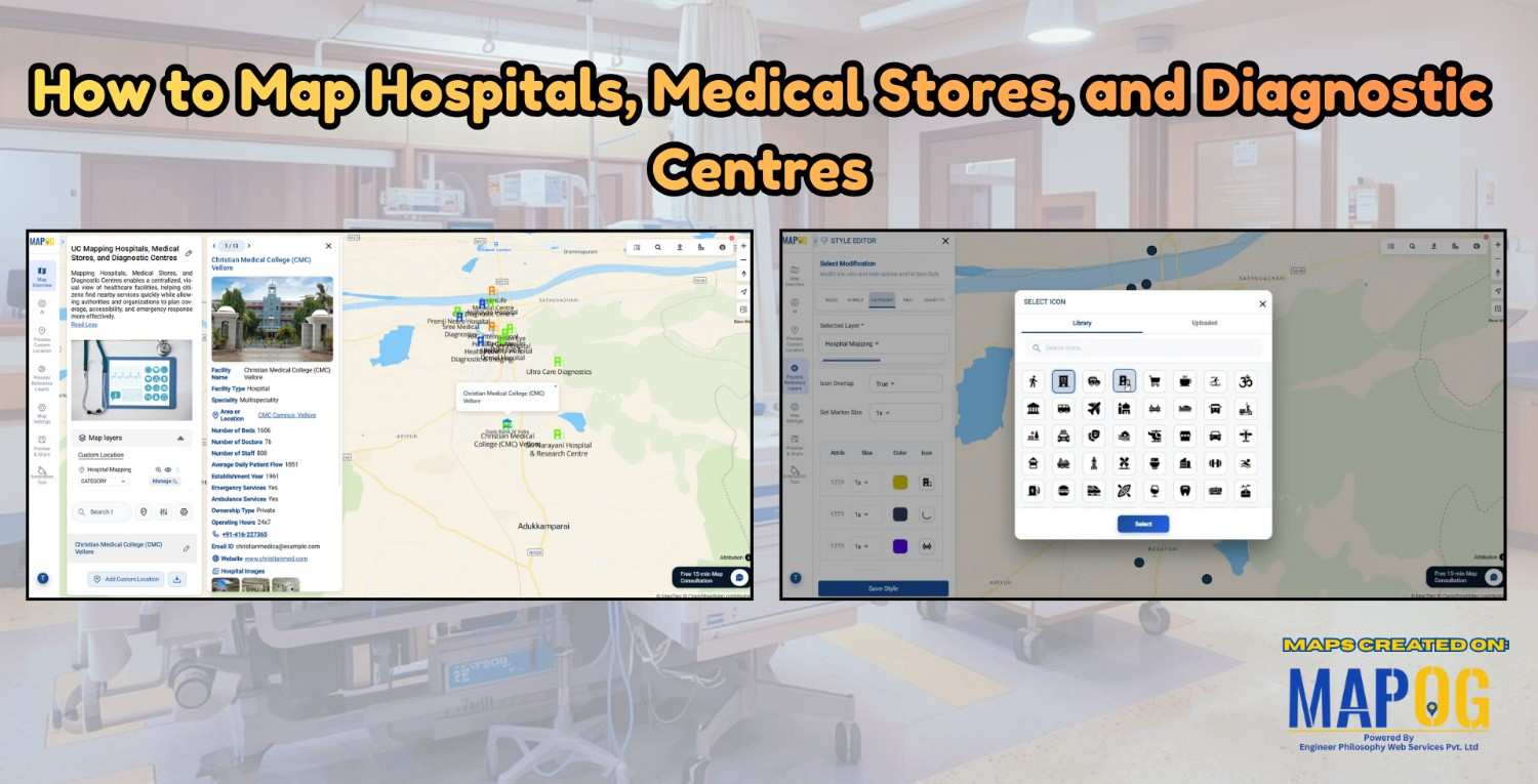
Health

How to Map Water ATMs and Community Taps for Equitable Access to Clean Drinking Water.

Mapping Water ATMs and Community Taps for Equitable Access to Clean Drinking Water

Indeed Access to safe drinking water is firstly a basic human right, however many underserved neighborhoods for instance still face challenges in finding electric stations and  clean water sources. Thus how to map Water ATMs and community taps using MAPOG provides a comparable data-driven solution in like manner to visualize access gaps and plan interventions. … Read more

Fire Station Mapping: How GIS Fire Safety Maps Improve Emergency Response & Community Safety

Fire station mapping is an important step as fires spread fast, and when communities lack nearby fire stations, hydrants, or safety infrastructure, the risk of damage rises dramatically. That’s why mapping fire safety infrastructure has become an essential tool for city planners, emergency responders, and local authorities. furthermore using GIS-based interactive tools like MAPOG to … Read more

Interactive Healthcare Map Locate Hospitals, Clinics, Diagnostic Labs & Health Centers

How to Create an Interactive Healthcare Map: Visualize Hospitals, Clinics, and Diagnostic Labs

Healthcare is vital for every community, and using an interactive healthcare map makes it easier to locate the nearest hospital, clinic, or diagnostic lab. With tools like MAPOG, it’s now possible to visualize the entire healthcare network of a city on a single platform. An interactive healthcare map makes it easy to categorize facilities, and … Read more

Smart Hospital Maps: How Interactive Mapping Improves Patient Navigation & Care

Optimizing patient care in a hospital requires a clear view of how different clinical centers, labs, and departments are distributed across the campus. Therefore, a smart hospital campus map improves visibility, efficiency, and decision-making by making navigation simple for patients, staff, and visitors. Using MAPOG, you can create an interactive hospital map that visualizes healthcare … Read more

How GIS Identifies Medical Investment Hubs for Strategic Healthcare Real Estate Growth

Investing in healthcare-focused real estate requires precise Medical Investment Hubs with GIS mapping to identify prime locations near hospitals, clinics, and medical research centers. Likewise, by plotting healthcare hubs, nearby amenities, and transport access, planners and investors can ensure informed decisions, strategic growth, and community well-being using interactive maps with healthcare and property data. Key … Read more

Using GIS to Map Nearest Blood Banks to Hospitals

How GIS Maps the Nearest Blood Banks to Hospitals for Faster Emergency Response

GIS to Map Nearest Blood Banks to Hospitals is revolutionizing emergency healthcare infrastructure. This powerful application enables medical professionals, urban planners, and public health officials to improve accessibility, cut response times, and ensure blood availability during crises. MAPOG provides real-time insights, helping decision-makers coordinate resources and strengthen healthcare networks. Why Use GIS for Mapping the … Read more

Mapping Hospital Coverage and Categories Using Convex Hull

Mapping Rural Hospital Coverage Using GIS and Convex Hull

Mapping Hospital Coverage and Categories, locations in rural areas ensures that communities have access to essential healthcare during emergencies. Visualising hospital distribution and overall coverage helps identify underserved regions and gaps in healthcare infrastructure. With MAPOG, users can build interactive GIS maps showing hospital points, health facility types, and Convex Hull polygons that represent the … Read more

Ambulance Accessibility & Response Time Analysis

In life-threatening emergencies, every second counts. Consequently, ambulances must reach patients quickly. However, in many cities, emergency response times are slowed down by poor planning, traffic congestion, or lack of infrastructure. This is precisely where Geographic Information Systems (GIS) step in. Platforms like MAPOG are transforming how cities visualize Ambulance Accessibility & Response all without … Read more

Mapping Healthcare Deserts in India

Identifying Areas with Limited Access to Doctors and Medical Facilities Mapping healthcare deserts in India helps expose one of the biggest barriers to healthcare access: geography. Although access to healthcare is a fundamental right, how soon someone can reach a hospital often depends more on location than need. Healthcare desert mapping—regions where timely access to … Read more

How GIS Helps in Hospital Site Selection and Healthcare Accessibility Analysis

How GIS Helps in Hospital Site Selection and Healthcare Accessibility Analysis

 In our fast-evolving cities and growing rural communities, access to healthcare is a basic need which still remains unevenly distributed. The healthcare revolution arises from Geographic information Systems (GIS) which enables complex data to be converted into life-saving decisions such as hospital site selection and healthcare  Through integration of several layers, GIS produces an accurate … Read more