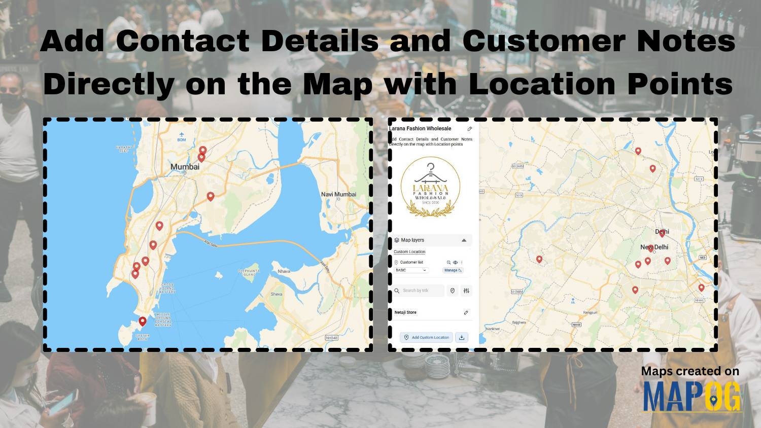
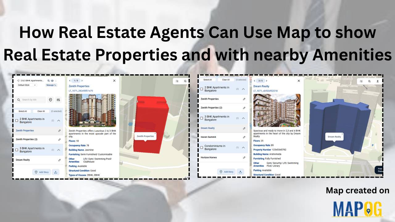
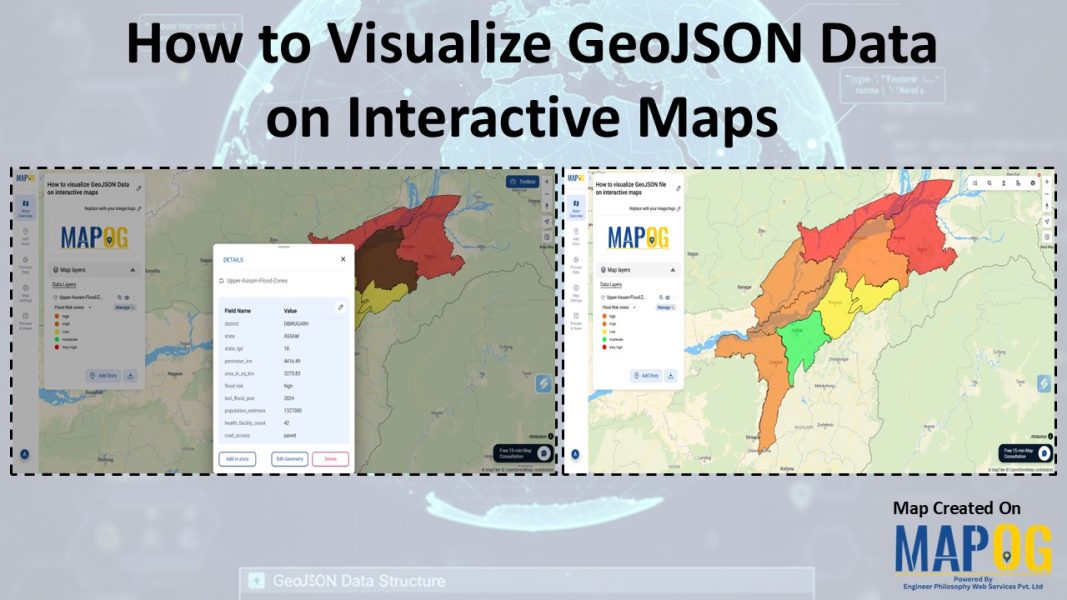
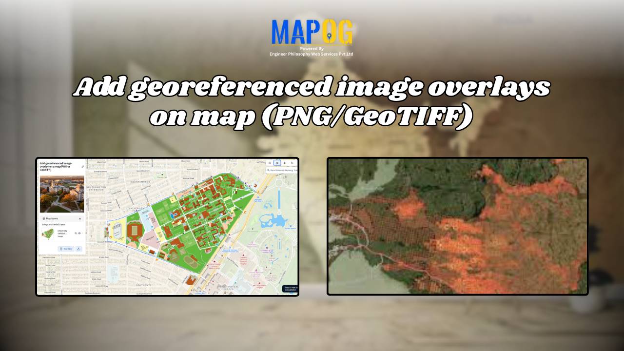
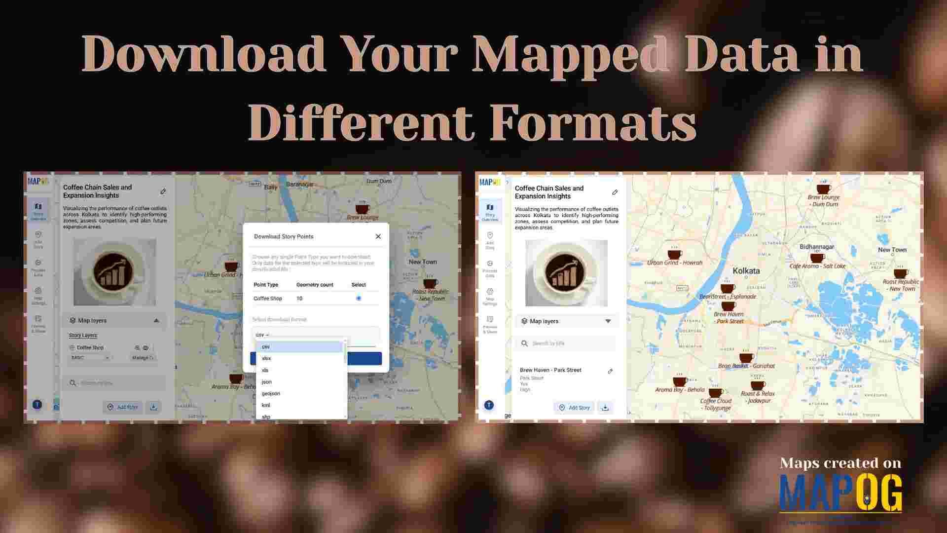
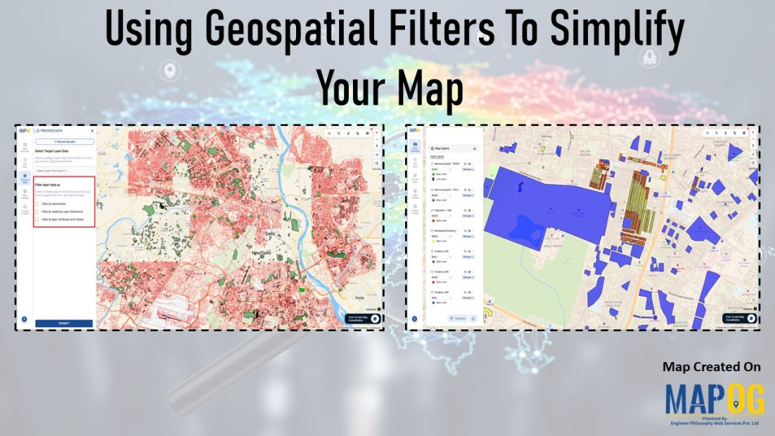
GISdata

Fire Station Mapping: How GIS Fire Safety Maps Improve Emergency Response & Community Safety

Fire station mapping is an important step as fires spread fast, and when communities lack nearby fire stations, hydrants, or safety infrastructure, the risk of damage rises dramatically. That’s why mapping fire safety infrastructure has become an essential tool for city planners, emergency responders, and local authorities. furthermore using GIS-based interactive tools like MAPOG to … Read more

Mapping Public Amenities to Spot Underserved Areas and Plan New Developments

Public Amenities Mapping with GIS: How Cities Can Improve Schools, Hospitals, Parks & Community Services

Mapping Public Amenities to transform your city into a granted transparent, inclusive, and well-planned urban space with GIS-powered public amenity mapping. This modern approach enables governments, planners, and communities to visualize essential services such as schools, hospitals, parks, libraries, and more on a single interactive map. By identifying underserved areas as much as cities can … Read more

Smart Hospital Maps: How Interactive Mapping Improves Patient Navigation & Care

Optimizing patient care in a hospital requires a clear view of how different clinical centers, labs, and departments are distributed across the campus. Therefore, a smart hospital campus map improves visibility, efficiency, and decision-making by making navigation simple for patients, staff, and visitors. Using MAPOG, you can create an interactive hospital map that visualizes healthcare … Read more

Visualize Your Entire College on an Interactive Campus Map

Interactive Campus Map: Visualize Your Entire College with Smart Digital Navigation

Visualize Your Entire College into a smart, navigable, and interactive digital hub with GIS-powered campus mapping. This modern solution allows colleges and universities to showcase their entire infrastructure—academic buildings, hostels, sports arenas, cultural centers, and even upcoming event venues—on a single interactive map. In this case students, faculty, visitors, and alumni gain instant access to … Read more

How GIS Identifies Medical Investment Hubs for Strategic Healthcare Real Estate Growth

Investing in healthcare-focused real estate requires precise Medical Investment Hubs with GIS mapping to identify prime locations near hospitals, clinics, and medical research centers. Likewise, by plotting healthcare hubs, nearby amenities, and transport access, planners and investors can ensure informed decisions, strategic growth, and community well-being using interactive maps with healthcare and property data. Key … Read more

Hotel Campus Map for Guests Visualize Amenities, Dining, Pools, and Activities

Hotel Campus Map: How to Create an Interactive Guide to Amenities, Dining & Activities for Better Guest Experience & Operations

In modern hospitality, a Hotel Campus Map ensures great experiences aren’t just delivered—they’re mapped. Static floor plans and printed brochures no longer give guests the clarity or convenience they expect. As a result, hotels are now using Hotel Campus Map to showcase facilities—from pools and restaurants to rooms and event spaces—visually and in real time.—from … Read more

Mapping Coastline Marathon with GIS

How to Use GIS for Coastline Marathon Route Mapping and Logistics

Mapping Coastline Marathon organizing a marathon along coastline requires accurate GIS mapping . By plotting hydration points, medical tents, and key milestones, planner, smooth logistics, and a great runner experience without complex crowd-flow simulations, using interactive maps with coastline and checkpoint data. Key Concept: Mapping Coastline Marathon Identifies: Uses of Mapping Coastline Marathon Methodology: Mapping … Read more

How GIS Mapping Helps Farmers Manage Irrigation and Reduce Water Waste

GIS in irrigation has become a cornerstone of sustainable agriculture, particularly in the face of increasing water scarcity and climate variability. In this context, one of the most powerful tools that enables farmers and planners to optimize water resources. By combining spatial data with advanced mapping techniques, GIS not only helps farmers manage irrigation more … Read more

Identifying Flood Prone region and Safe Zones using GIS

How to Use GIS to Identify Flood-Prone Areas and Map Safe Zones using buffer analysi

Identifying Flood Prone region near rivers is vital for disaster preparedness. Using GIS buffer analysis, a 1 km zone around rivers highlights vulnerable settlements, enabling rapid flood-risk estimation, mapping of exposed regions, and informed mitigation planning without complex hydrological modeling. So users can build interactive flood risk maps by integrating river data, and key land-use … Read more

Monitor Deforestation-Free Farming Using GIS Mapping and Spatial Analysis Tools

In sustainable land management, it’s critical to monitor deforestation-free farming using spatial GIS tools that help understand how agriculture interacts with ecosystems. As deforestation becomes a pressing concern, agri-businesses and regulators require spatial evidence to ensure farming doesn’t encroach on forested areas. With MAPOG, spatial data becomes a powerful tool for environmental accountability and transparent … Read more