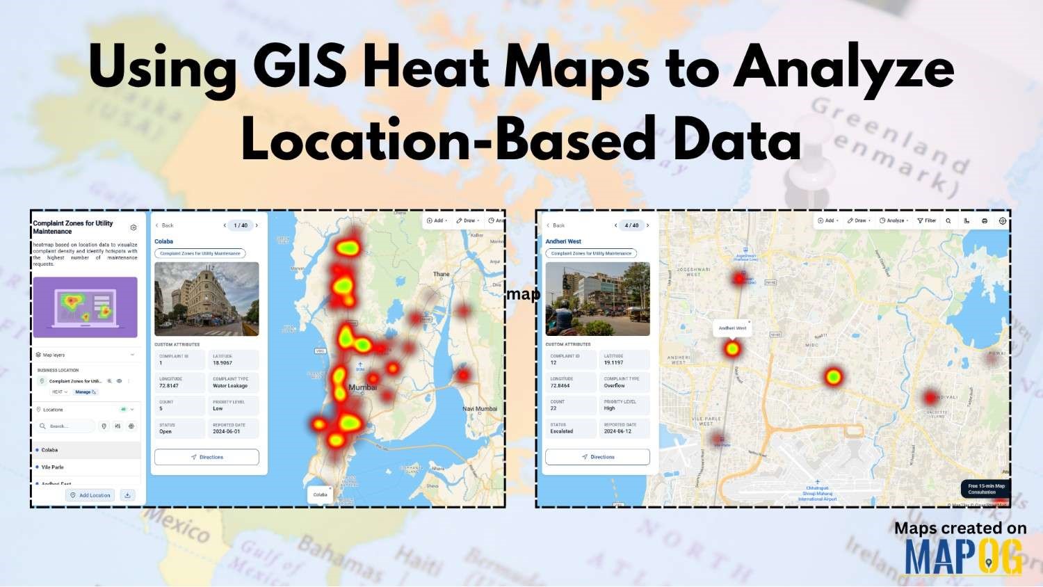
Online Mapping

MAPOG platform interface showing solar installation sites on a map with filters and detailed task information for a rooftop solar project.

Manage Solar Panel Installations, Procurement, and Maintenance Tasks on a Map

Managing solar projects across multiple sites is complex, as each location has its own installations, deliveries, and maintenance, while updates are scattered across systems. As a result, delays and overlaps lead to repeated work. MAPOG helps manage solar panel installations by linking sites, tasks, and updates on a map for clearer planning and execution. Key Concept: … Read more

Shows dashboard, task setup panels, and map interface for installation management.

How to Assign Installation Jobs to Locations on a Map

Managing Ed-tech hardware installations across multiple sites is challenging. Field teams face communication gaps, travel delays, and unclear tracking, leaving managers unsure about progress or payments. MAPOG solves scheduling by letting managers assign installation jobs to locations, track status, and verify tasks with completion forms, all seamlessly. Key Concept: Why Assign Installation Jobs to Locations When … Read more

Manage Scattered Property Listings with category-based maps in MAPOG

Manage Scattered Property Listings Using Category-Based Maps

Real estate brokers often struggle to Manage Scattered Property Listings spread across multiple neighborhoods. As portfolios grow, spreadsheets become fragmented, updates are frequently missed, and tracking individual property status becomes confusing. To solve this, brokers can utilize MAPOG to convert static data into a centralized, visual map. Key concept: Manage Scattered Property Listings Through a … Read more

creating solar survey installation easier way

Conduct Solar Site Surveys and Assess Installation Feasibility Using Mobile Data Collection

In solar infrastructure projects, inaccurate site observations and delayed updates often slow down execution, leading to redesign and cost overruns. Traditionally, teams rely on manual notes, scattered spreadsheets, or calls, which reduces accuracy and visibility. To address this, companies are now conduct solar site surveys using mobile data collection and digital mapping workflows. This approach … Read more

tracking camera installation

Track Installation Locations and Coverage Using an Interactive Map

Camera installation service checks are often managed through spreadsheets, calls, and scattered messages, which leads to confusion about exact track installation locations, delayed updates, and poor visibility into task progress. As a result, technicians may miss follow-ups or revisit sites due to unclear information. However, by using map-based task management in the MAPOG platform, every … Read more

How to Conduct Field Surveys and Store Data on a Map for Analysis

How to Conduct Field Surveys and Store Data on a Map for Analysis

Healthcare systems often face fragmented data and limited visibility, therefore planning and service delivery become challenging. However, MAPOG mobile data collection capability helps teams conduct Healthcare Facility Surveys and analyze accessibility by capturing accurate field surveys and store data in real time, ensuring consistency and enabling faster, data-driven decisions. Key Concepts: Field Surveys and Store … Read more

Store Map vs Default Map: Why Store Mapping is Better for Retail and Franchise Businesses

Store Map vs Default Map: Why Store Mapping is Better for Retail and Franchise Businesses

Managing multiple store locations using standard maps often limits visibility, branding, and customer engagement. Default maps provide only basic location details, while MAPOG enables businesses to build fully customized store maps with branded icons, rich information, and interactive features. Store Map vs Default map improves store discovery, enhances customer experience, and supports better decision-making for … Read more

Manage Site Visits and Client Property Tours on a Single Location Using Task Management

Manage Site Visits and Client Property Tours on a Single Location Using Task Management

Scattered records make it difficult to manage site visits and client property tours in the real estate industry, but MAPOG transforms visit data into a single interactive map. It improves location visibility, coordination, and scheduling while supporting faster decision-making. Track tasks, monitor visits, and ensure accountability using real-world spatial context instead of spreadsheets. Key Concept: … Read more

Capture inspection photos and notes from on site location

Capture Inspection Photos and Notes from On-Site Location

Across sectors that rely on regular site checks—such as property management, facility maintenance, construction, and infrastructure monitoring—teams often capture inspection photos and notes using phones, paper records, or scattered messages, which leads to missing records, unclear locations, and reporting delays. With MAPOG’s mobile data collection, inspections are linked to precise locations. Field teams capture geotagged … Read more

Map based Task Management

Manage Builder Tasks Like Electrical, Plumbing, and Pipeline Work on a Map Using Task Management

Construction projects involve multiple parallel activities happening across different parts of a site. To manage builder tasks like electrical wiring, plumbing installation, and pipeline work that often run simultaneously, handled by different teams. Without a structured system, tracking progress becomes difficult, and delays become common. A map-based task management approach using MAPOG, helps manage builder … Read more