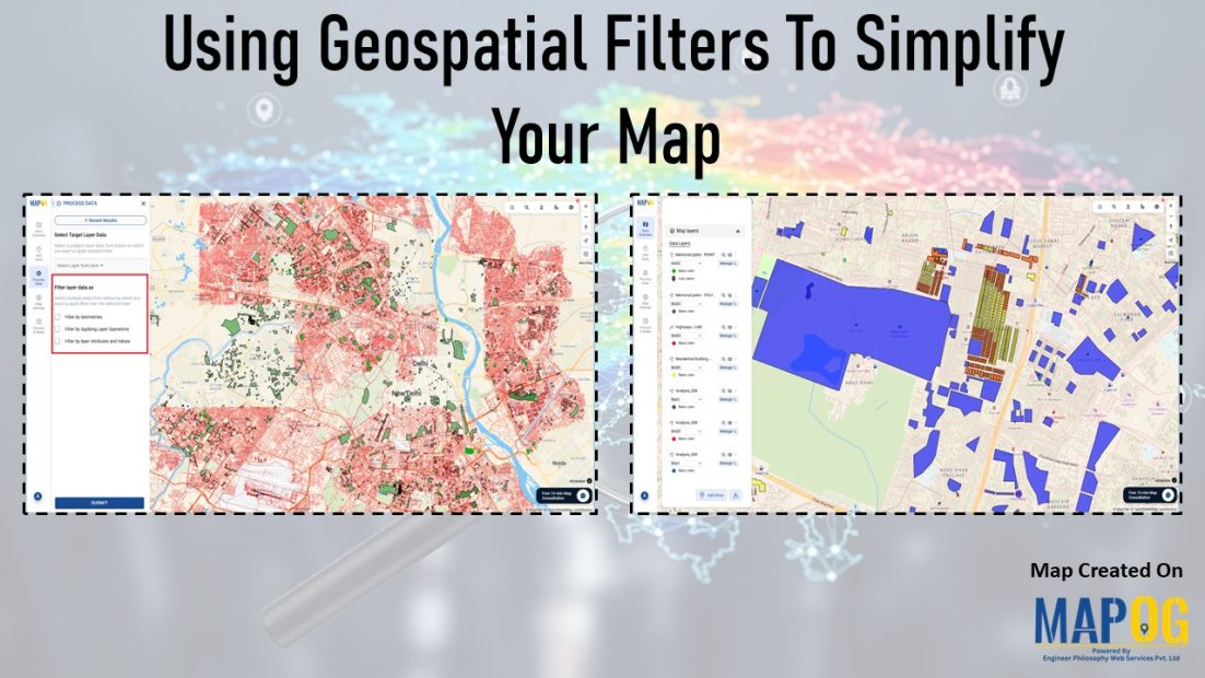
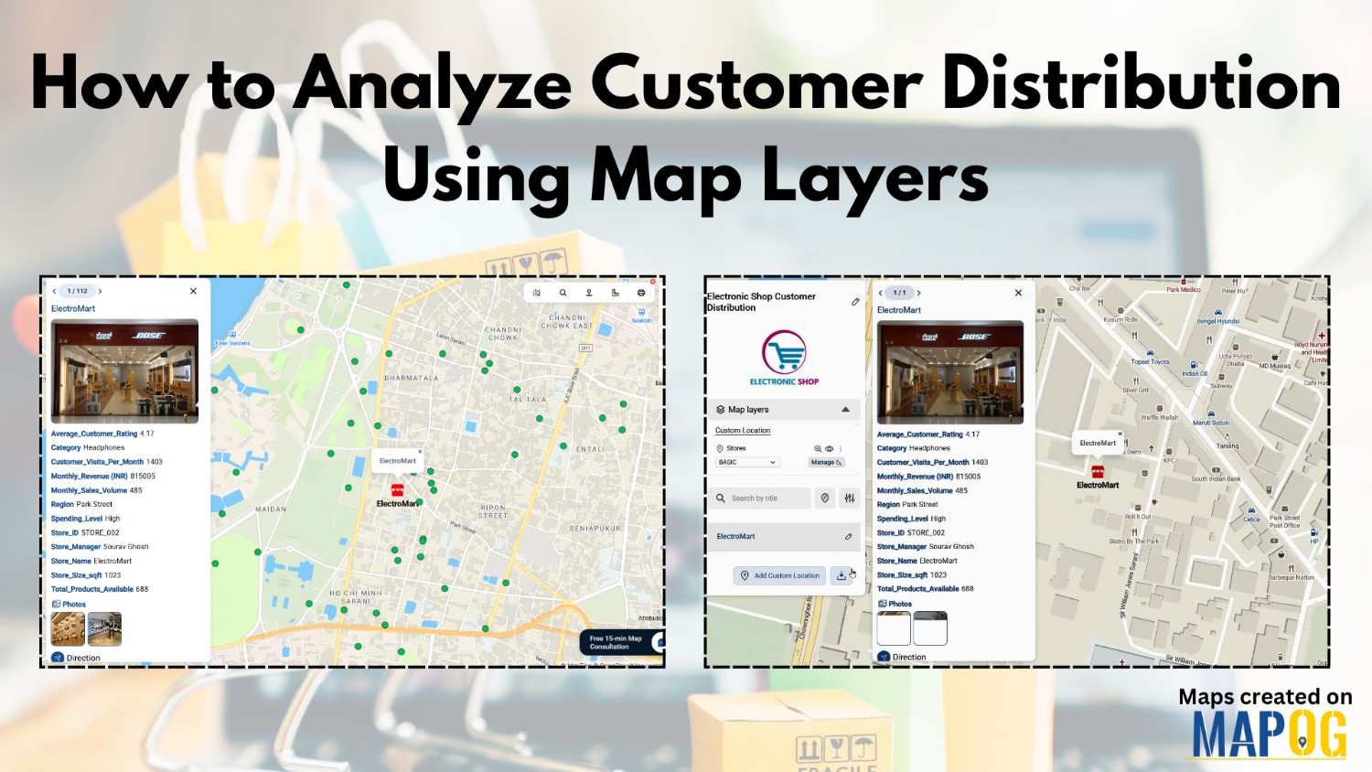
MAPOG Analysis

How to Map Crops Online: Step-by-Step Guide for Farmers, Planners, and Researchers

Mapping crops on a map platforms provides an effective way to categorize, analyze, and visualize agricultural data. By organizing crop information into clear layers, farmers, planners, and researchers can better understand agricultural trends and regional strengths. This method not only helps in identifying where each crop thrives but also supports long-term planning, monitoring, and sharing … Read more

electric aerial vehicle routes

How to Plan Efficient Electric Aerial Vehicle Routes Using Bearing Angle and Distance

Planning efficient electric aerial vehicle routes is, therefore, becoming essential in industries like logistics, disaster response, and surveillance. Not only does a precise route save time, but it also ensures flight safety and energy optimization. Consequently, MAPOG simplifies this process by combining bearing angle & distance calculations with real-world coordinates. In this article, we’ll explore … Read more

Monitor Deforestation-Free Farming Using GIS Mapping and Spatial Analysis Tools

In sustainable land management, it’s critical to monitor deforestation-free farming using spatial GIS tools that help understand how agriculture interacts with ecosystems. As deforestation becomes a pressing concern, agri-businesses and regulators require spatial evidence to ensure farming doesn’t encroach on forested areas. With MAPOG, spatial data becomes a powerful tool for environmental accountability and transparent … Read more

Mapping History with GIS: Turn Historical Events into Interactive Stories

Historical events have, over centuries, shaped civilisations and cultures. Consequently, mapping history with GIS tools provides new insights into how past events unfolded geographically. As a result, this promotes deeper engagement, improves retention, and simultaneously encourages an immersive way of exploring timelines and stories. Moreover, by integrating GIS tools with historical data, storytelling becomes more … Read more

How to Map Waste Disposal Sites Near Residential Areas Using GIS Buffer Analysis

In today’s expanding urban landscapes, Mapping Waste Disposal Sites and the safe management of waste is a growing concern for both communities and city planners. Improperly placed waste disposal sites can pose serious health and environmental risks, especially when located too close to residential areas. Issues such as air and water pollution, unpleasant odors, and … Read more

GIS for Deforestation Tracking

How to Use GIS for Deforestation Tracking and Forest Loss Analysis

Using GIS for deforestation tracking has become a powerful approach in environmental research. Every year, massive tree cover disappears. Therefore, tracking these changes accurately becomes essential for timely forest conservation efforts. GIS helps researchers and conservationists visualize forest loss clearly and over time. Consequently, it enables faster and smarter decision-making. One of the simplest tools … Read more

Mapping Military Flight Paths

Mapping Military Flight Paths: How GIS Helps Calculate Distance and Bearing Angles

Mapping Military Flight Paths is a crucial component in modern aerial defense planning. With the continuous rise of geographic intelligence, GIS technology now plays a central role in not only plotting accurate coordinates but also in calculating distances and determining precise bearing angles. This process, therefore, goes far beyond simply drawing lines on a map—it … Read more

Add Excel Data to Geographic Boundaries

Visualize Excel Data on a Map: Join Spreadsheet Data with Location Layers

If you’re looking to add Excel data to geographic boundaries using Excel attributes, you’re stepping into one of the most efficient ways to visualize and analyze location-based data. Whether it’s population statistics, sales figures, or demographic details, aligning spreadsheet data with geospatial boundaries helps uncover trends you might otherwise miss. Fortunately, MAPOG simplifies this process … Read more

Create a Buffer Analysis to Locate Hospital Within 5km radius of Village

Finding healthcare gaps isn’t just about counting hospitals. Rather, it’s about understanding access, travel range, and unserved rural zones. Therefore, with the help of MAPOG, planners and health departments can visualize these relationships using buffer analysis. Additionally when used in combination with choropleth-style overlays, village point layers, or service area mapping tools, MAPOG makes it … Read more

Mapping Emergency Services Near Education Institutions Using GIS

How to Map Emergency Services Near Educational Institutions Using GIS Tools

Ensuring the emergency services Near Education become more critical than ever safety of students in educational institutions is a high priority in urban and regional planning. As cities expand rapidly and population density increases.  This article explains how Geographic Information Systems (GIS) can be effectively used to map emergency services near educational institutions. For this … Read more