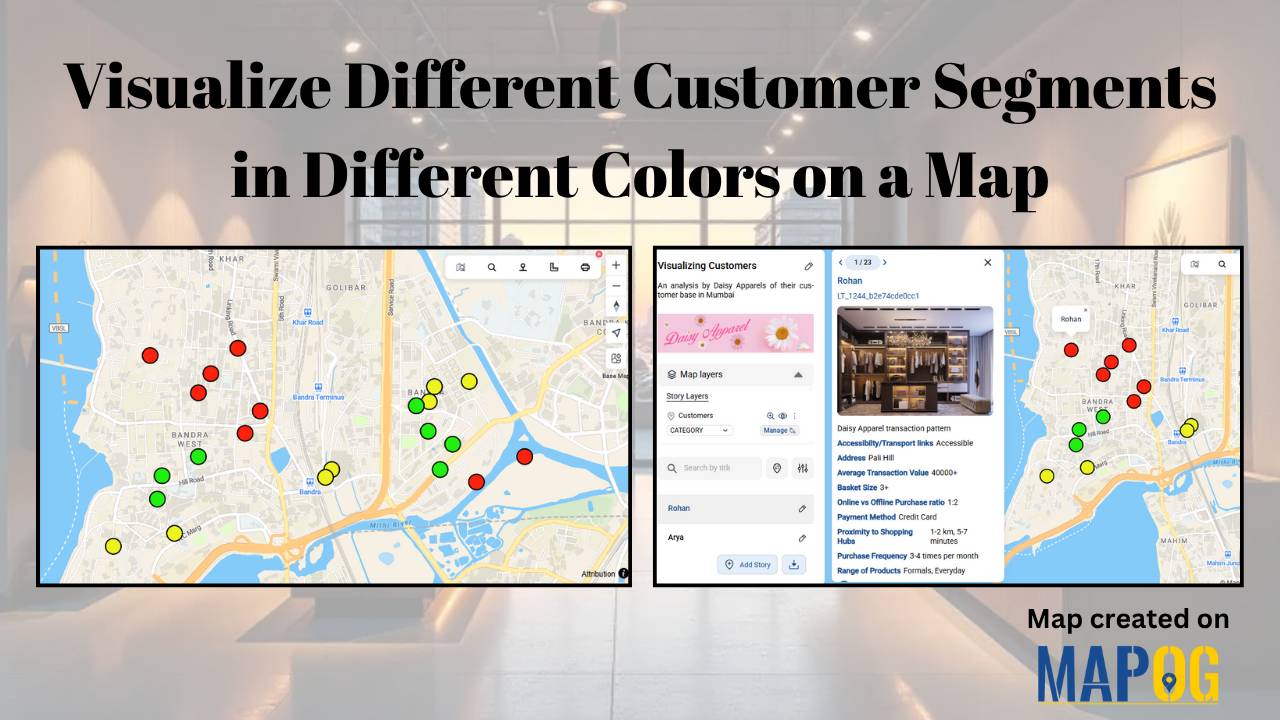
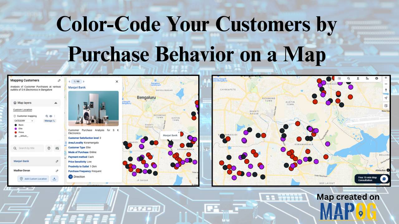
#Smartmapping

Hotel Campus Map for Guests Visualize Amenities, Dining, Pools, and Activities

Hotel Campus Map: How to Create an Interactive Guide to Amenities, Dining & Activities for Better Guest Experience & Operations

In modern hospitality, a Hotel Campus Map ensures great experiences aren’t just delivered—they’re mapped. Static floor plans and printed brochures no longer give guests the clarity or convenience they expect. As a result, hotels are now using Hotel Campus Map to showcase facilities—from pools and restaurants to rooms and event spaces—visually and in real time.—from … Read more

How to Create a Car Delivery Map with Customer Photos & Reviews [Step-by-Step Guide]

When people buy a car, the delivery moment naturally becomes a memory worth keeping. Therefore, a Happy Customer Car Delivery Map seamlessly brings those stories together in one interactive platform. By combining delivery photos, customer names, and car details across different locations, dealerships can not only showcase their happiest moments but also strengthen trust. Moreover, … Read more

On-Map Travel Planning How to Build and Share Interactive Itineraries

On-Map Travel Planning: How to Build and Share Interactive Itineraries Transform Client Experiences

On-Map Travel Planning: How Interactive Itineraries Transform Client Experiences In modern travel , clients no longer want static itineraries—they want to see their journey unfold. Traditional PDFs and spreadsheets may list activities, but they fail to convey geography, movement, or the emotional arc of a trip. This is where on-map travel planning changes the game. … Read more

How to Map Crops Online: Step-by-Step Guide for Farmers, Planners, and Researchers

Mapping crops on a map platforms provides an effective way to categorize, analyze, and visualize agricultural data. By organizing crop information into clear layers, farmers, planners, and researchers can better understand agricultural trends and regional strengths. This method not only helps in identifying where each crop thrives but also supports long-term planning, monitoring, and sharing … Read more

How to Create Interactive Real Estate Portfolio Maps: Organize, Visualize, and Showcase Projects

In real estate development, success isn’t just built—it’s mapped. Today’s developers are moving beyond static brochures to embrace tools like interactive real estate portfolio map. Hence, these dynamic tools allow developers to present their projects with clarity, connectivity, and context. For example, just as agents use maps to help homebuyers understand surroundings, developers are now … Read more

electric aerial vehicle routes

How to Plan Efficient Electric Aerial Vehicle Routes Using Bearing Angle and Distance

Planning efficient electric aerial vehicle routes is, therefore, becoming essential in industries like logistics, disaster response, and surveillance. Not only does a precise route save time, but it also ensures flight safety and energy optimization. Consequently, MAPOG simplifies this process by combining bearing angle & distance calculations with real-world coordinates. In this article, we’ll explore … Read more

Monitor Deforestation-Free Farming Using GIS Mapping and Spatial Analysis Tools

In sustainable land management, it’s critical to monitor deforestation-free farming using spatial GIS tools that help understand how agriculture interacts with ecosystems. As deforestation becomes a pressing concern, agri-businesses and regulators require spatial evidence to ensure farming doesn’t encroach on forested areas. With MAPOG, spatial data becomes a powerful tool for environmental accountability and transparent … Read more

Mapping History with GIS: Turn Historical Events into Interactive Stories

Historical events have, over centuries, shaped civilisations and cultures. Consequently, mapping history with GIS tools provides new insights into how past events unfolded geographically. As a result, this promotes deeper engagement, improves retention, and simultaneously encourages an immersive way of exploring timelines and stories. Moreover, by integrating GIS tools with historical data, storytelling becomes more … Read more

GIS for Deforestation Tracking

How to Use GIS for Deforestation Tracking and Forest Loss Analysis

Using GIS for deforestation tracking has become a powerful approach in environmental research. Every year, massive tree cover disappears. Therefore, tracking these changes accurately becomes essential for timely forest conservation efforts. GIS helps researchers and conservationists visualize forest loss clearly and over time. Consequently, it enables faster and smarter decision-making. One of the simplest tools … Read more

Mapping Military Flight Paths

Mapping Military Flight Paths: How GIS Helps Calculate Distance and Bearing Angles

Mapping Military Flight Paths is a crucial component in modern aerial defense planning. With the continuous rise of geographic intelligence, GIS technology now plays a central role in not only plotting accurate coordinates but also in calculating distances and determining precise bearing angles. This process, therefore, goes far beyond simply drawing lines on a map—it … Read more