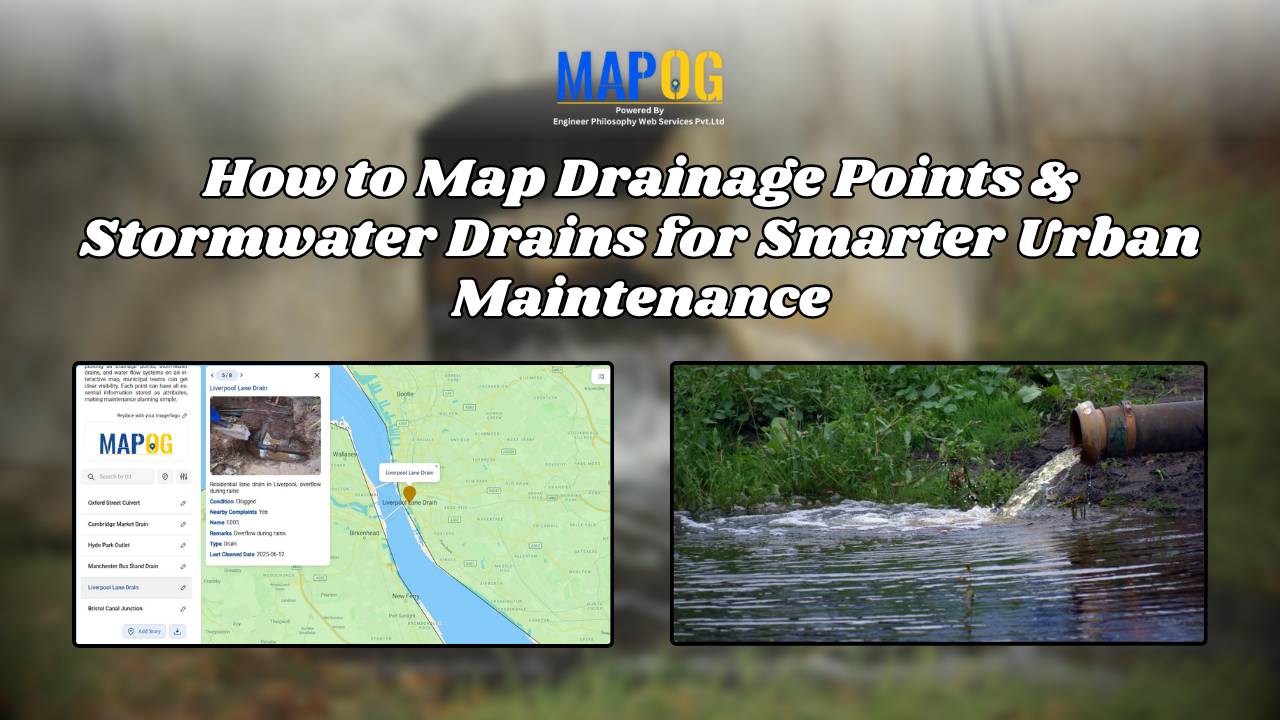
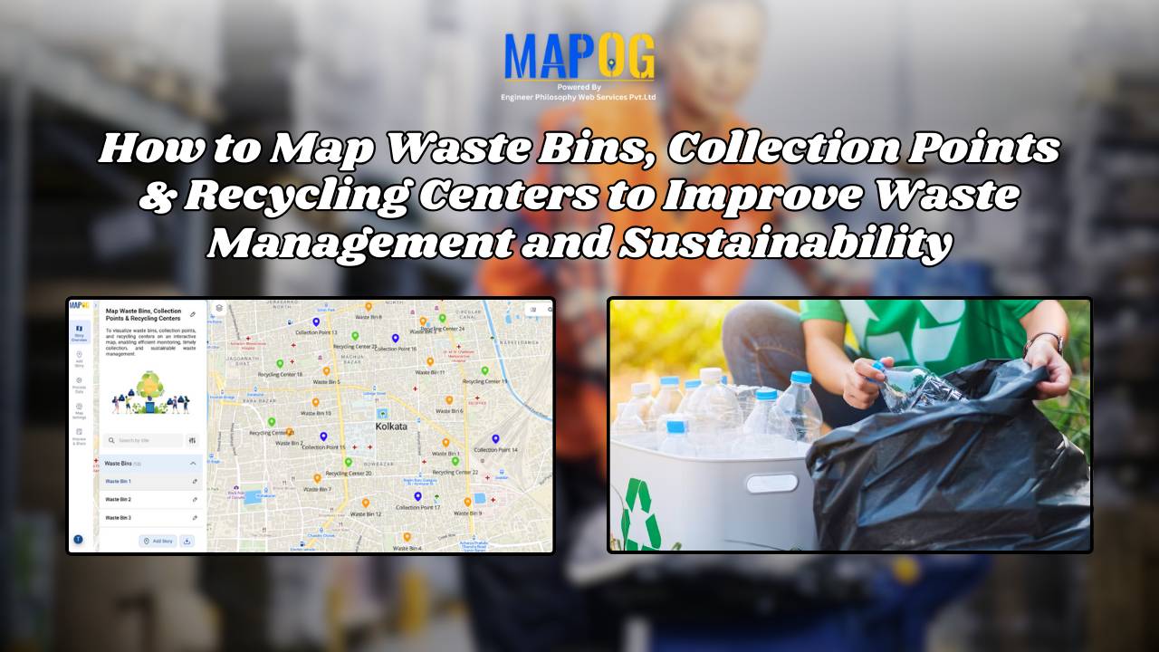
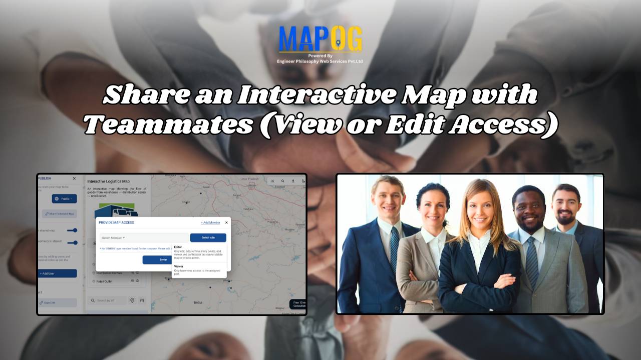
Interactive Mapping

How to Map and Manage a Franchise Business with Location and Service Filters

If you’re planning to expand your food chain or track multiple branches across cities, then learning how to map a franchise business with smart filters is a true breakthrough. By doing so, you can visualize store data on an interactive platform, which in turn helps you easily organize locations, services, and customer insights. Whether you’re … Read more

How to Map Rental Properties with Nearby Amenities Using Interactive GIS Maps

Whether you’re a real estate agent, property manager, or investor, mapping rental properties with key nearby amenities gives your listings the edge. In fact, visual maps offer clarity, transparency, and better decision-making for both renters and owners. By combining precise coordinates with contextual data—such as distance from schools, hospitals, or parks—you ultimately make the rental … Read more

How to Use GIS Mapping for Solar Development A Step-by-Step Guide to Smart Site Selection

How to Use GIS Mapping for Solar Development: A Step-by-Step Guide to Smart Site Selection

Planning utility-scale Solar Site Suitability Mapping projects with MAPOG involves overlaying layers like GHI, land parcels, flood zones, and transmission lines. Spatial filters quickly eliminate unsuitable areas, helping prioritize sites that are both high in solar potential and accessible to the grid streamlining smart, data-driven solar development. Key Concept: Solar Site Suitability Mapping While many … Read more

Mapping Cyclone Shelter Locations for Coastal Safety Using GIS

Mapping Cyclone Shelter Locations for Coastal Villages Using GIS

Mapping Cyclone Shelter Locations in coastal villages need quick access to shelters during emergencies. Visualizing shelter locations and their accessibility helps uncover gaps in disaster readiness. With MAPOG, users can build interactive GIS maps showing shelter distribution, village settlements, roads, and key geographic features. Instead of complex tools, this method uses simple layers and spatial … Read more

How GIS on Map Helps Optimize Public Transport Routes and Reduce Traffic

In today’s urban landscape, GIS for public transport optimisation is basically transforming how cities tackle congestion and improve mobility. By integrating spatial data with transit planning altogether, Geographic Information Systems help planners design smarter, more efficient transport routes that reduce traffic, improve accessibility, and enhance commuter satisfaction. Understanding GIS for Public Transport Optimization and Why … Read more

How Real Estate Agents Use Maps to Sell Properties Smarter

How Real Estate Agents Use Maps to Sell Properties Smarter

In real estate, using real estate map tools helps agents present not just the property, but its location benefits too. More agents now use interactive maps to help buyers understand not just the home, but its surroundings—like nearby parks, schools, transit, and conveniences. Embedding maps into property listings makes websites more engaging. When buyers can … Read more

Create a Travel Journal on a Map – Add Photos, Notes & Pins

Create a Travel Journal on a Map – Add Photos, Notes & Pins

Planning your next adventure? Don’t just jot down your stops—Create a Travel Journal on a Map to capture every moment. A Travel Journal Map helps you organize memories by location, add photos and notes, and visually share your journey. With MAPOG, it’s easy to plan your route, add key locations, and share it online with … Read more

GIS Mapping of Landslide

GIS Mapping of Landslide-Prone Villages and Road Accessibility

In recent years, the importance of GIS Mapping of Landslide-prone areas has grown significantly. As climate conditions continue to worsen and extreme weather becomes more frequent, it is becoming increasingly critical to assess not only the vulnerable zones but also how surrounding communities and nearby roads can be affected. Consequently, this blog will walk you … Read more

GIS Mapping Public Service

How GIS Mapping Optimizes Public Service Delivery in Municipalities

In today’s data-driven world, GIS Mapping Optimizes Public Service Delivery by transforming how cities manage essential services. MAPOG help planners visualize, analyze, and optimize infrastructure such as waste management, healthcare, and safety. With targeted layers like Public Health Maps and tools to Map EV Charging Stations, cities address both core needs and sustainability goals. As … Read more

Create Story Maps for Education: A Visual Way to Teach History, Geography, and More

Visual storytelling through maps offers a dynamic way to teach history, making abstract timelines and political shifts more tangible. When learners can Create Story Maps for Education, they visualize how historical events unfolded across space, leading to deeper understanding. For example, using a British India interactive map, educators can illustrate how the British Empire expanded—from … Read more