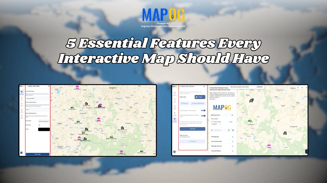
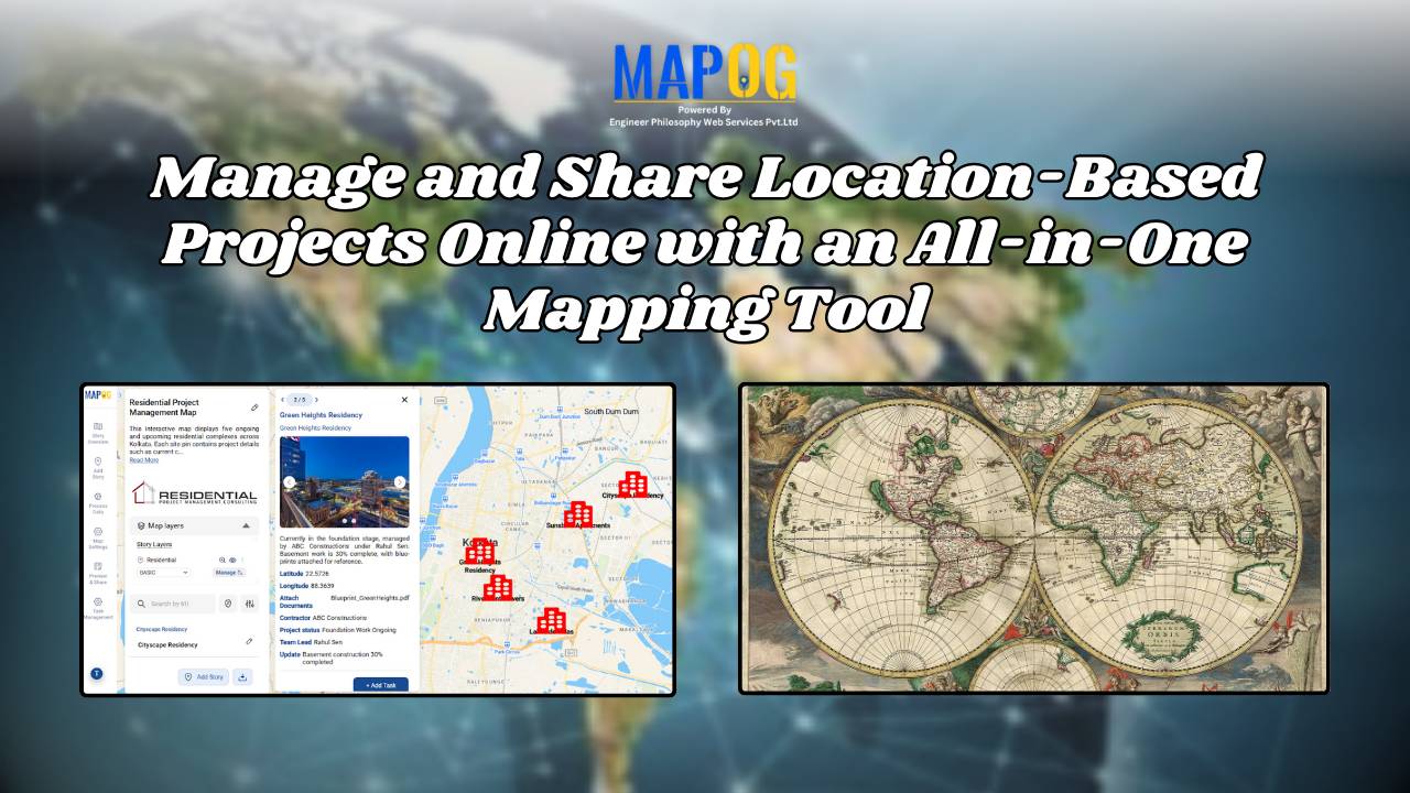
Tourism

How to Create a Safari Itinerary Map for Your Trip

Create & Share a Safari Itinerary Map for Your Trip

If you’re planning a safari, visualizing your journey on a map can turn your travel plans into an interactive and shareable experience. From visiting to all safari locations and back, mapping your safari helps you track routes, highlight wildlife hotspots, and organize activities. Using MAPOG, you can create a rich safari itinerary map that’s engaging, … Read more

Interactive Map of Hotel Chain Properties & Nearby Attractions

How to Find Hotels with Nearby Attractions: Interactive Maps for Smarter Travel Planning

As travelers seek more convenient and memorable experiences, choosing the right hotel often goes beyond the room itself—it’s about the location and what surrounds it. Guests frequently struggle to find nearby attractions, restaurants, or entertainment options, especially when traveling to new destinations. This lack of visibility can lead to missed opportunities and less satisfying stays. … Read more

How to Showcase Your Hotel with an Interactive Property Map for Better Guest Engagement

When travelers look for a luxury stay, undoubtedly, visuals play a powerful role in influencing their decision. This is where you can showcase your hotel with Interactive Property Map to highlight not only your rooms but also the real advantage of your location. Moreover, by designing an engaging map with MAPOG, hotels can transform their … Read more

How to Map Destination Wedding Venues with Photos & Details

How to Map Destination Wedding Venues with GIS: Interactive Planning, Travel Insights & Venue Storytelling

How to map Destination weddings venues. It combine travel, culture, and celebration into one unforgettable experience, finding facilities like hospitals, and even explore different styles. In addition, this approach promotes better decision-making, while simultaneously inspiring new ideas and allowing for interactive exploration of venues. Moreover, by integrating GIS tools like MAPOG with venue data, wedding … Read more

On-Map Travel Planning How to Build and Share Interactive Itineraries

On-Map Travel Planning: How to Build and Share Interactive Itineraries Transform Client Experiences

On-Map Travel Planning: How Interactive Itineraries Transform Client Experiences In modern travel , clients no longer want static itineraries—they want to see their journey unfold. Traditional PDFs and spreadsheets may list activities, but they fail to convey geography, movement, or the emotional arc of a trip. This is where on-map travel planning changes the game. … Read more

Best Alternatives to Google My Maps for Sharing Travel Stories

Best Alternatives to Google My Maps for Sharing Travel Stories

If you’re on the lookout for the best alternatives to Google My Maps, you’re not alone. Travelers, bloggers, and content creators are increasingly seeking more flexible, interactive, and storytelling-driven platforms to share their travel memories. While Google My Maps offers basic map-making features, it often falls short in terms of personalization, multi-user collaboration, and storytelling … Read more

Creating a Story Map of Monuments and Share or Embed It Anywhere

A Story Map of Monuments using MAPOG transforms how we explore cultural heritage. Instead of static lists, it offers a visual journey through India’s architectural legacy—organized by district or state. Whether you’re promoting tourism, documenting history, or supporting heritage conservation, a story Map of Monuments using MAPOG brings depth and context that traditional formats can’t … Read more

Top places to Visit Across India – Visual Travel Guide on Map

India is more than a destination it’s a vibrant journey through culture, nature, and heritage. With the MAPOG code-free mapping platform, you can effortlessly transform your travel plans or blog into an interactive visual experience, highlighting top places to visit across India. From sacred sites to scenic wonders, bring India’s diversity to life all in … Read more

Country Wise UNESCO Guide: Top Heritage Spots on a Map

Create Countrywise UNESCO Map: Top Heritage Spots Guide

Create a country-wise UNESCO Guide Map that highlights both cultural brilliance and natural wonders. On the other hand, by integrating GIS tools, this project enhances public awareness, encourages responsible tourism, and supports heritage preservation. It offers users an educational and immersive storytelling experience that makes exploring global heritage sites more accessible, insightful, and engaging. Key … Read more

Create an Online Map to Visualize and Collaborate on the 7 Wonders of the World

Learn geography & history by creating an interactive map that highlights the 7 Wonders of the World.

Discover geography and history by creating an interactive map of the 7 Wonders of the World—ideal for students, educators, and explorers. These iconic sites highlight human creativity, engineering, and cultural identity, each reflecting the unique legacy of its civilization. Using Geographic Information Systems (GIS), you can combine geography, history, and travel planning into an engaging … Read more