Story on Map

Track Task Progress on a Map

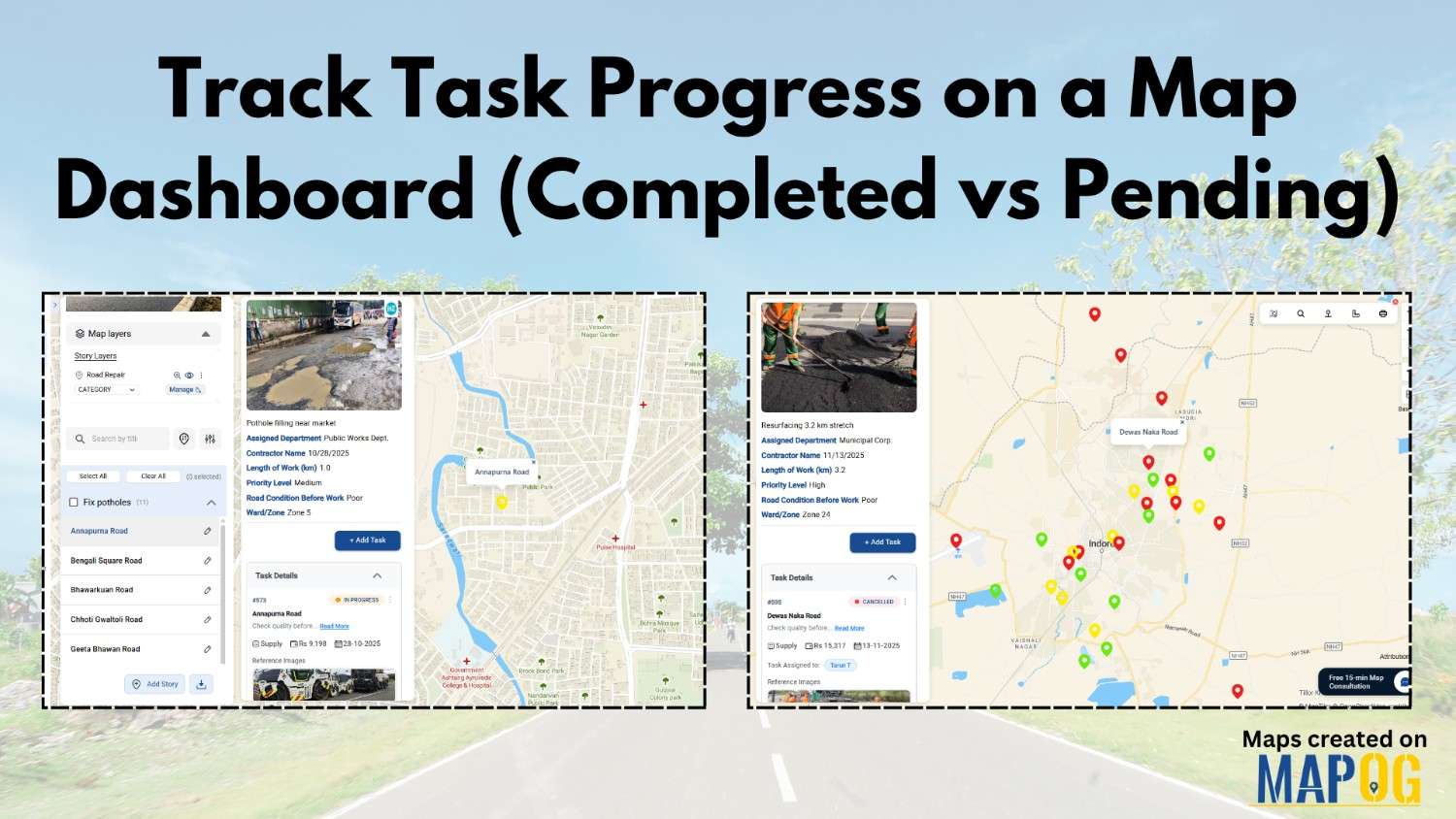
Track Task Progress on a Map Dashboard (Completed vs Pending)

Tracking everyday projects on spreadsheets often turns messy, especially when tasks spread across different teams and locations. Instead of flipping through endless reports, a smarter way is to track task progress visually on a map dashboard. This approach gives you an instant view of what’s done and what’s pending while also keeping everything more organized. … Read more

Measure Distance & Area on a Map (Free Online Tool)

Measure Distance & Area on a Map (Free Online Tool)

Measuring distance and area is a fundamental tool with a wide range of applications like calculating land parcels, determining the lengths of roads and rivers. Leveraging MAPOG one can measure distance and area enabling to analyze and manage geospatial data for more informed and efficient decision making. Key concept and importance The key concept of … Read more

Share an Interactive Map with Teammates (View or Edit Access)

Best Way to Share Interactive Maps Online with View and Edit Access

Today, readers and team members expect more than just static information when exploring content or managing data online. Whether it’s tracking locations, updating details, or monitoring progress, interactive maps make collaboration simple and engaging. With MAPOG, you can easily share an Interactive Map with teammates, assigning view or edit access to ensure the right people … Read more

Embed a Live Interactive Map on Your Website or WordPress

Embed a Live Interactive Map on Your Website or WordPress

Today, readers expect more than plain text when exploring content online. To begin with, a simple list of destinations, business locations, or data points often fails to hold attention. This is why the ability to embed a live interactive map makes a difference. Instead of static descriptions, maps let audiences explore places visually, click on … Read more

How to Map Water ATMs and Community Taps for Equitable Access to Clean Drinking Water.

Mapping Water ATMs and Community Taps for Equitable Access to Clean Drinking Water

Indeed Access to safe drinking water is firstly a basic human right, however many underserved neighborhoods for instance still face challenges in finding electric stations and  clean water sources. Thus how to map Water ATMs and community taps using MAPOG provides a comparable data-driven solution in like manner to visualize access gaps and plan interventions. … Read more

How to Create a Safari Itinerary Map for Your Trip

Create & Share a Safari Itinerary Map for Your Trip

If you’re planning a safari, visualizing your journey on a map can turn your travel plans into an interactive and shareable experience. From visiting to all safari locations and back, mapping your safari helps you track routes, highlight wildlife hotspots, and organize activities. Using MAPOG, you can create a rich safari itinerary map that’s engaging, … Read more

Famous Alumni Map Discover Notable Personalities and Their Universities

Famous Alumni Map: Showcase Notable University Graduates, Achievements & Success Stories

Universities are the birthplaces of leaders, innovators, and change makers. Mapping notable alumni with MAPOG showcases their achievements, highlights global impact, and inspires future generations by tracing where their journeys began through a famous alumni map. Key Concepts: Why Create a Famous Alumni Map? Alumni achievements are often scattered, but a digital map highlights them … Read more

How Interior Designers Can Manage Projects On-Map, Not on Spreadsheets

Managing interior design projects often feels overwhelming, especially when updates are scattered across WhatsApp chats, shared drives, and endless spreadsheets. For years, spreadsheets seemed like the go-to option; however, they usually fail to provide clarity when teams need real-time visualisation across multiple sites. That’s exactly where interactive maps step in. With MAPOG, Interior design project … Read more

Mapping Public Amenities to Spot Underserved Areas and Plan New Developments

Public Amenities Mapping with GIS: How Cities Can Improve Schools, Hospitals, Parks & Community Services

Mapping Public Amenities to transform your city into a granted transparent, inclusive, and well-planned urban space with GIS-powered public amenity mapping. This modern approach enables governments, planners, and communities to visualize essential services such as schools, hospitals, parks, libraries, and more on a single interactive map. By identifying underserved areas as much as cities can … Read more

Listing Flats Villas Commercial: How Interactive Maps Transform Real Estate Listings

How to List Flats, Villas & Commercial Properties on One Interactive Map

Listing flats, villas, and commercial spaces in today’s competitive real estate market comes with its own set of challenges. Developers and agents often struggle to present their complete portfolio in an engaging and organised way. Buyers, on the other hand, want to explore properties with context, neighbourhood insights, and trust in the builder—all in one … Read more