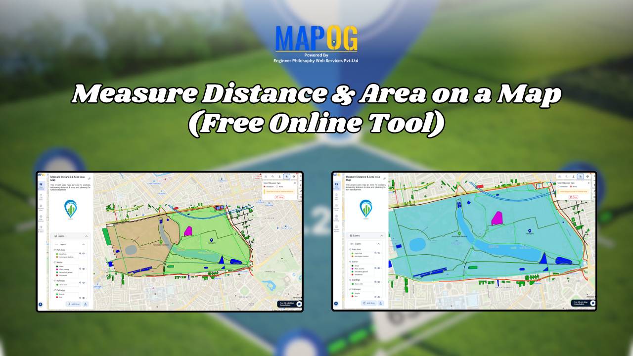
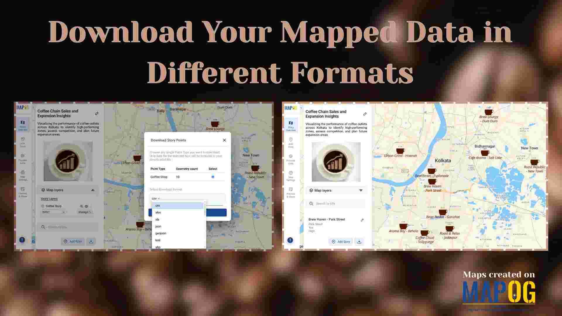
Land Use

Free GIS Mapping Tools for Students and Researchers

Free GIS Mapping Tools for Students and Researchers

In today’s logistics-driven world, Geographic Information Systems (GIS) play a pivotal role in analyzing spatial data for informed decision-making. Fortunately, MAPOG offers Free GIS Mapping Tools that empower students, researchers, and planners to explore and visualize real-world location-based patterns. With tools such as Buffer Zones, Clip and Isochrones, users can easily identify optimal sites for … Read more

GIS Tool for Organic Farming

Using GIS Tools to Identify Best Sites for Organic Farming and Increase Yield

With the rise of sustainable agriculture, organic farming meanwhile emerges as a key method for eco-friendly food production. However, its long-term success depends, above all, on precise site selection. Fortunately, with the help of a GIS Tool for Organic Farming, such as MAPOG, users can seamlessly adopt Smart Farming with GIS. Moreover, by seamlessly layering … Read more

Create Map to Identify Groundwater Decline and Recharge Gaps Using GIS Tools

Groundwater mapping using GIS tools is becoming essential as groundwater decline and recharge gaps raise serious concerns—especially in regions that rely heavily on underground water resources. Fortunately, by using GIS technology, stakeholders can now visualize, Role of GIS In Irrigation Planning and Water Resource Management to these changes more efficiently than ever before. Moreover, with … Read more

GIS for real estate

GIS in Identifying High-Growth Areas for Real Estate Investment

In today’s fast-evolving urban landscape, identifying the right location for real estate investment is both a science and a strategy. GIS helps in Identifying High-Growth Areas is a go-to approach for investors and planners aiming to make informed, data-backed decisions. From analyzing transportation access to mapping nearby amenities, GIS adds a new level of depth … Read more

GIS helps in solar energy site suitability and analysis

How GIS helps in Solar Energy Site Suitability and Analysis

In today’s renewable energy movement, GIS helps in solar energy site suitability and analysis by providing precision, clarity, and data-driven decisions. This blog unpacks how Geographic Information Systems are transforming how we identify optimal solar farm locations, ensuring both efficiency and environmental harmony. Through a practical example using real GIS tools, you’ll discover how layered … Read more

wildlife monitoring and prevention using gis tool

How to use GIS for Wildlife monitoring and prevention

As biodiversity faces unprecedented loss, conservationists are using advanced mapping technology to fight back. Geographic Information Systems (GIS) have evolved into powerful tools for wildlife monitoring and protection, enabling teams to plan migration corridors, predict poaching hotspots. This technology is empowering rangers and researchers to make faster, smarter decisions, helping reverse biodiversity loss. Key Concept … Read more

GIS in land use and zoning analysis for better city planning

GIS in Land use and Zoning analysis for better city planning

In today’s fast-changing urban landscape, GIS in land use and zoning analysis for better city planning plays a vital role in shaping smarter, more livable cities. Whether it’s managing population growth, conserving green spaces, or optimizing infrastructure, city planners increasingly depend on GIS to make informed decisions. This article explores how GIS tools enhance zoning … Read more

Flood Risk Mapping with Interactive Web Maps: A SaaS Platform Approach

Flood Risk Mapping with Interactive Web Maps: SaaS Approach

A SaaS-based flood risk mapping platform leverages interactive web maps to provide risk assessments. Using GIS, AI, and hydrological data, it enables governments, insurers, and communities to visualize flood-prone areas, enhance preparedness, and optimize response strategies. Cloud-based accessibility ensures scalability, data integration, and seamless user collaboration for proactive risk management. Key Concept How Flood Risk … Read more

How to use GIS for Soil Mapping and Crop Monitoring

GIS is crucial in agriculture for soil mapping and crop monitoring, enabling informed decisions to improve yield, optimize land use, and ensure sustainable farming. It helps identify soil types, track crop density, and enhance precision farming by processing and visualizing soil and crop data. Key Concepts in GIS for Soil Mapping and Crop Monitoring GIS … Read more