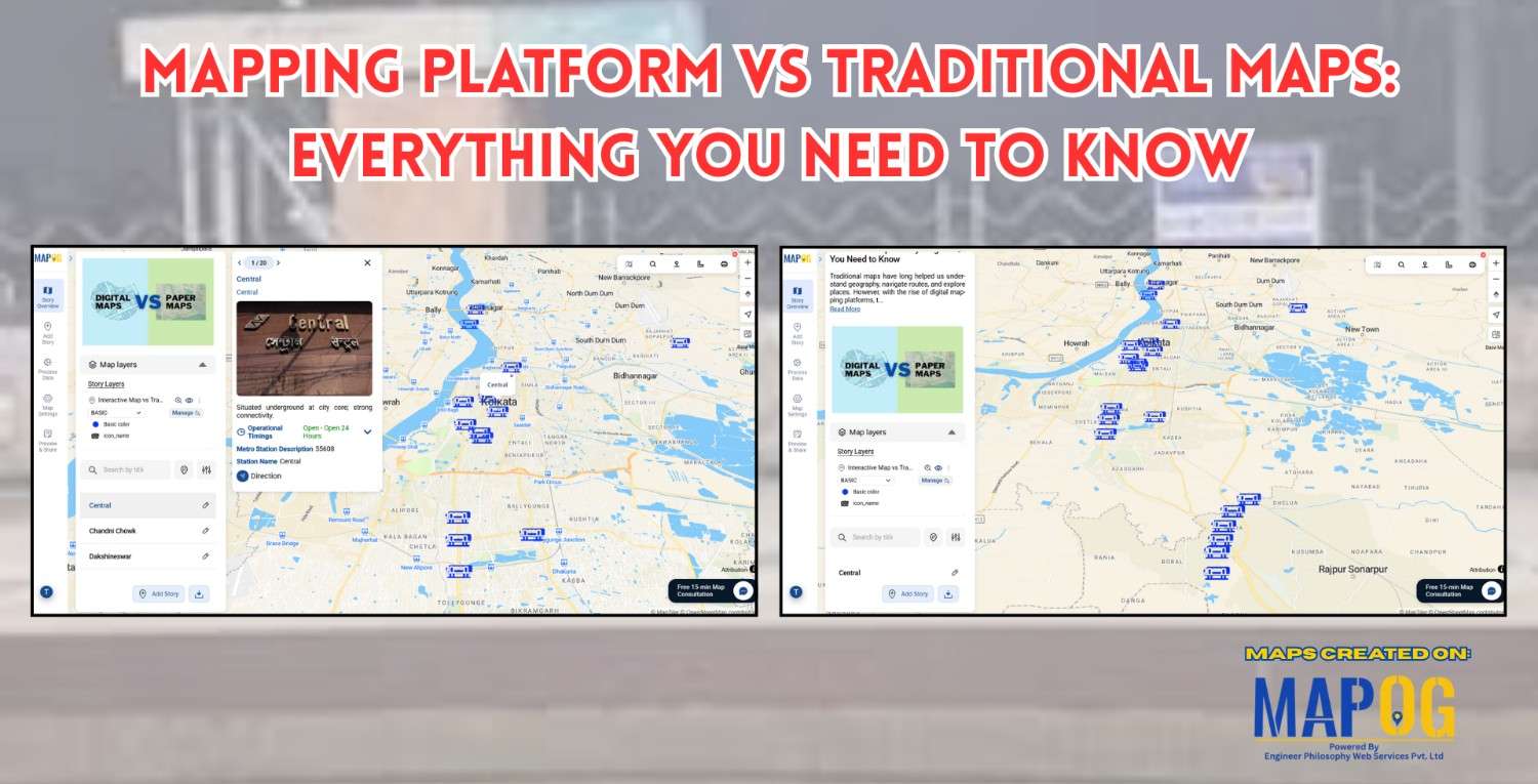
Site selection

Create Map of Sewage Lines and Water Cross-points for Urban Infra Projects

In urban planning, mapping sewage lines and water isn’t just about locating pipelines—it’s about understanding how systems connect and where they fall short  Therefore, as cities expand, planners need clear ways to visualize the relationship between sewage networks and treatment facilities. As a result, with MAPOG, spatial data becomes actionable insight. Mapping sewage and drainage … Read more

Performing Retail Site Selection with Convex Hull Analysis

Performing Retail Site Selection with Convex Hull Analysis

Choosing the right retail location goes beyond guessing where people shop. Instead it’s about recognizing spatial clusters, identifying market gaps, and optimizing coverage. With this in mind, MAPOG, retailers can make data-driven decisions by interpreting customer and store distributions visually. Coupled with heat bubble styling, grid-based analysis, or retail site selection , MAPOG enables smarter … Read more

Top places to Visit Across India – Visual Travel Guide on Map

India is more than a destination it’s a vibrant journey through culture, nature, and heritage. With the MAPOG code-free mapping platform, you can effortlessly transform your travel plans or blog into an interactive visual experience, highlighting top places to visit across India. From sacred sites to scenic wonders, bring India’s diversity to life all in … Read more

Mapping Borewell Locations Near Rivers and Lakes with GIS-Based Tools

Mapping borewell locations near rivers and lakes is not only vital for understanding groundwater dependencies but also essential for ensuring sustainable usage. In fact, in regions where surface water and groundwater interact closely, analyzing borewell proximity to these natural water bodies becomes even more crucial. Moreover, with the help of GIS-based tools like MAPOG, users … Read more

Create Map to Identify Groundwater Decline and Recharge Gaps Using GIS Tools

Groundwater mapping using GIS tools is becoming essential as groundwater decline and recharge gaps raise serious concerns—especially in regions that rely heavily on underground water resources. Fortunately, by using GIS technology, stakeholders can now visualize, Role of GIS In Irrigation Planning and Water Resource Management to these changes more efficiently than ever before. Moreover, with … Read more

How to Map and Share Retail Store Locations for Your Franchise?

In today’s data-driven world, the ability to map retail store locations for your franchise is one of the smartest moves you can make. Just as visualizing a Safari Itinerary on a map helps travelers craft immersive and efficient journeys, or mapping Spatial Retail Store Analysis with GIS tools enables cities to improve safety and planning, … Read more

“A digital map highlighting water-scarce villages and nearby water sources in India using GIS tools, illustrating buffer zones, village boundaries, and water infrastructure.”

GIS-Based Mapping of Water-Scarce Villages and Nearest Water Sources

Water scarcity continues to challenge many rural areas across India. With shifting climate patterns, population pressures, and the overuse of natural resources, numerous villages face both seasonal and long-term water stress. However, Mapping Groundwater Concentration through GIS presents a powerful approach to this issue. By visualizing the availability and distribution of subsurface water, it becomes … Read more

GIS in Identifying High-Growth Areas for Real Estate Investment

GIS in Identifying High-Growth Areas for Real Estate Investment

In today’s fast-evolving urban landscape, identifying the right location for real estate investment is both a science and a strategy. GIS helps in Identifying High-Growth Areas is a go-to approach for investors and planners aiming to make informed, data-backed decisions. From analyzing transportation access to mapping nearby amenities, GIS adds a new level of depth … Read more

How to create Major Historical Battles and War Sites Map

History isn’t just about events it’s about where they happened. From ancient conquests to world wars, every major battle unfolded on a map. In this guide, we’ll walk through how to build a stunning “Historical Battles and War Sites” story map using MAPOG. you can transform history into an interactive journey by creating a “Major … Read more

How to Upload and Visualize CSV Data on a Map

How to Upload and Visualize CSV Data on a Map

In today’s digital world, knowing how to upload and visualize CSV data on a map is essential for urban planning, environmental monitoring, and compelling visual storytelling. Moreover, with the growing importance of data-driven storytelling and location-based insights, MAPOG provides an intuitive platform to transform your spreadsheet data into interactive maps. As a result, users can … Read more