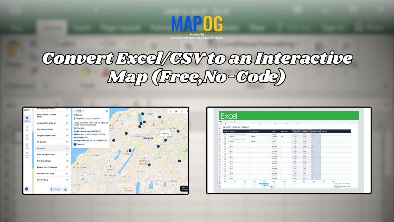
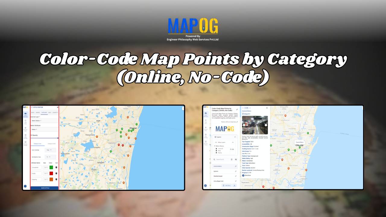
GIS in Education

Incredible India Itinerary: A Cultural Circuit on the Map

Incredible India Itinerary: A Cultural Circuit on the Map

India is a land of diverse cultures, rich heritage, and vibrant traditions. When you think of exploring the true essence of India, it’s not just about ticking off touristy landmarks; it’s about diving deep into the heart of its culture. In this guide, we’ll show you how to create an cultural circuit on map, connecting … Read more

Power Grid and Infrastructure mapping and planning using GIS

Power Grid and Infrastructure mapping and planning using GIS

Geographic Information Systems (GIS) are revolutionizing power grid mapping and infrastructure planning. By linking geospatial intelligence with electrical grid data, GIS enables utility companies and energy planners to visualize, assess, and optimize power distribution networks. Furthermore, it supports everything from the planning of substations and transmission lines to the ongoing monitoring of grid performance. As … Read more

How GIS Helps in Hospital Site Selection and Healthcare Accessibility Analysis

How GIS Helps in Hospital Site Selection and Healthcare Accessibility Analysis

 In our fast-evolving cities and growing rural communities, access to healthcare is a basic need which still remains unevenly distributed. The healthcare revolution arises from Geographic information Systems (GIS) which enables complex data to be converted into life-saving decisions such as hospital site selection and healthcare  Through integration of several layers, GIS produces an accurate … Read more

Mapping Top National Parks: Preserving Nature

Mapping Top National Parks: Preserving Nature

Mapping Top National Parks play a vital role in conserving biodiversity and protecting natural landscapes while offering recreational opportunities that connect people with the environment. Additionally, these protected areas serve as sanctuaries for endangered species, geological wonders, and cultural heritage. From towering mountain ranges to vast desert expanses, national parks also support sustainable tourism, scientific … Read more

GIS in Infrastructure Development and Road Network Analysis

GIS in Infrastructure Development and Road Network Analysis

GIS (Geographic Information Systems) plays a transformative role in the Road Network Analysis development and analysis of infrastructure, particularly in designing and optimizing road networks. By integrating spatial data with planning tools, GIS enables engineers, urban planners, and policymakers to make data-driven decisions. It supports the entire infrastructure lifecycle—from feasibility studies and planning to construction … Read more

Flood Risk Mapping with Interactive Web Maps: A SaaS Platform Approach

Flood Risk Mapping with Interactive Web Maps: SaaS Approach

A SaaS-based flood risk mapping platform leverages interactive web maps to provide risk assessments. Using GIS, AI, and hydrological data, it enables governments, insurers, and communities to visualize flood-prone areas, enhance preparedness, and optimize response strategies. Cloud-based accessibility ensures scalability, data integration, and seamless user collaboration for proactive risk management. Key Concept How Flood Risk … Read more

HOW GIS CAN HELP IN REDUCING URBAN HEAT ISLANDS WITH SMART MAPPING

How GIS and Smart Mapping Reduce Urban Heat Islands

GIS for Heat Island Reduction enables smart mapping to analyze temperature variations identify heat-prone areas, and optimize green spaces. It supports strategic tree planting, reflective surfaces, and heat-resistant materials. GIS-driven data aids urban planners in designing cooler, sustainable cities with improved land use, reducing heat retention and energy consumption. Key Concept: GIS for heat island … Read more

Retracing Gandhi’s Dandi March: A Digital Journey with Story on Map

Start a historical trail with MAPSTORY and follow the route and importance of “Gandhi’s Dandi Aviyan: A Path to Freedom with MAPSTORY” a critical event in the fight for India’s independence. Use MAPOG’s immersive mapping technology to explore the route and the significance of this historical march. Key Concepts This is a way to digitally … Read more