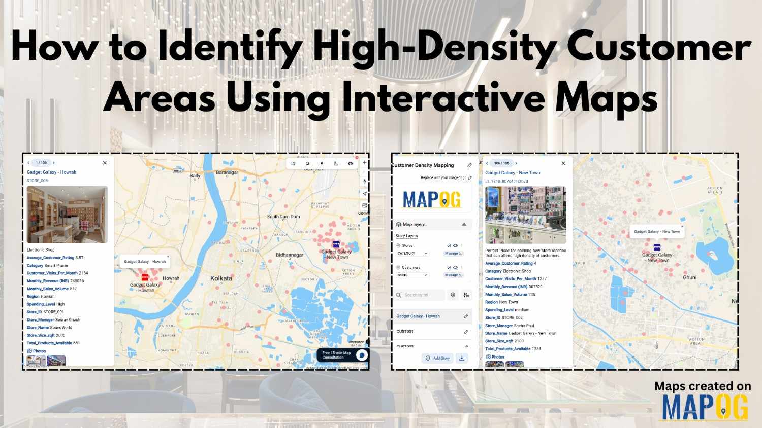
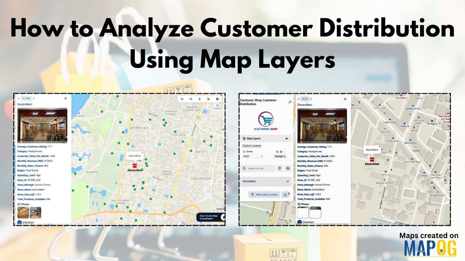
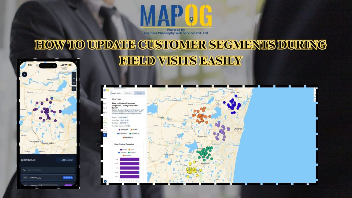
Advice

Mapping Public Amenities to Spot Underserved Areas and Plan New Developments

Public Amenities Mapping with GIS: How Cities Can Improve Schools, Hospitals, Parks & Community Services

Mapping Public Amenities to transform your city into a granted transparent, inclusive, and well-planned urban space with GIS-powered public amenity mapping. This modern approach enables governments, planners, and communities to visualize essential services such as schools, hospitals, parks, libraries, and more on a single interactive map. By identifying underserved areas as much as cities can … Read more

Interactive Map of Top Colleges and Universities for Students

Interactive Map of Top Colleges and Universities for Students: A Complete Guide to Choosing the Right Institution

Education shapes futures, and therefore knowing where the best institutions are located is essential for students, parents, and policymakers. Moreover, Interactive Map of Top Colleges and Universities for Students is not only exciting but also visually engaging. In addition, they help at the same time, to find nearby facilities such as electric vehicle stations. Furthermore, … Read more

Visualize Your Entire College on an Interactive Campus Map

Interactive Campus Map: Visualize Your Entire College with Smart Digital Navigation

Visualize Your Entire College into a smart, navigable, and interactive digital hub with GIS-powered campus mapping. This modern solution allows colleges and universities to showcase their entire infrastructure—academic buildings, hostels, sports arenas, cultural centers, and even upcoming event venues—on a single interactive map. In this case students, faculty, visitors, and alumni gain instant access to … Read more

How GIS Identifies Medical Investment Hubs for Strategic Healthcare Real Estate Growth

Investing in healthcare-focused real estate requires precise Medical Investment Hubs with GIS mapping to identify prime locations near hospitals, clinics, and medical research centers. Likewise, by plotting healthcare hubs, nearby amenities, and transport access, planners and investors can ensure informed decisions, strategic growth, and community well-being using interactive maps with healthcare and property data. Key … Read more

Using GIS to Map Nearest Blood Banks to Hospitals

How GIS Maps the Nearest Blood Banks to Hospitals for Faster Emergency Response

GIS to Map Nearest Blood Banks to Hospitals is revolutionizing emergency healthcare infrastructure. This powerful application enables medical professionals, urban planners, and public health officials to improve accessibility, cut response times, and ensure blood availability during crises. MAPOG provides real-time insights, helping decision-makers coordinate resources and strengthen healthcare networks. Why Use GIS for Mapping the … Read more

Mapping Coastline Marathon with GIS

How to Use GIS for Coastline Marathon Route Mapping and Logistics

Mapping Coastline Marathon organizing a marathon along coastline requires accurate GIS mapping . By plotting hydration points, medical tents, and key milestones, planner, smooth logistics, and a great runner experience without complex crowd-flow simulations, using interactive maps with coastline and checkpoint data. Key Concept: Mapping Coastline Marathon Identifies: Uses of Mapping Coastline Marathon Methodology: Mapping … Read more

Identifying Flood Prone region and Safe Zones using GIS

How to Use GIS to Identify Flood-Prone Areas and Map Safe Zones using buffer analysi

Identifying Flood Prone region near rivers is vital for disaster preparedness. Using GIS buffer analysis, a 1 km zone around rivers highlights vulnerable settlements, enabling rapid flood-risk estimation, mapping of exposed regions, and informed mitigation planning without complex hydrological modeling. So users can build interactive flood risk maps by integrating river data, and key land-use … Read more

Mapping Hospital Coverage and Categories Using Convex Hull

Mapping Rural Hospital Coverage Using GIS and Convex Hull

Mapping Hospital Coverage and Categories, locations in rural areas ensures that communities have access to essential healthcare during emergencies. Visualising hospital distribution and overall coverage helps identify underserved regions and gaps in healthcare infrastructure. With MAPOG, users can build interactive GIS maps showing hospital points, health facility types, and Convex Hull polygons that represent the … Read more

How to Use GIS Mapping for Solar Development A Step-by-Step Guide to Smart Site Selection

How to Use GIS Mapping for Solar Development: A Step-by-Step Guide to Smart Site Selection

Planning utility-scale Solar Site Suitability Mapping projects with MAPOG involves overlaying layers like GHI, land parcels, flood zones, and transmission lines. Spatial filters quickly eliminate unsuitable areas, helping prioritize sites that are both high in solar potential and accessible to the grid streamlining smart, data-driven solar development. Key Concept: Solar Site Suitability Mapping While many … Read more

Mapping Cyclone Shelter Locations for Coastal Safety Using GIS

Mapping Cyclone Shelter Locations for Coastal Villages Using GIS

Mapping Cyclone Shelter Locations in coastal villages need quick access to shelters during emergencies. Visualizing shelter locations and their accessibility helps uncover gaps in disaster readiness. With MAPOG, users can build interactive GIS maps showing shelter distribution, village settlements, roads, and key geographic features. Instead of complex tools, this method uses simple layers and spatial … Read more