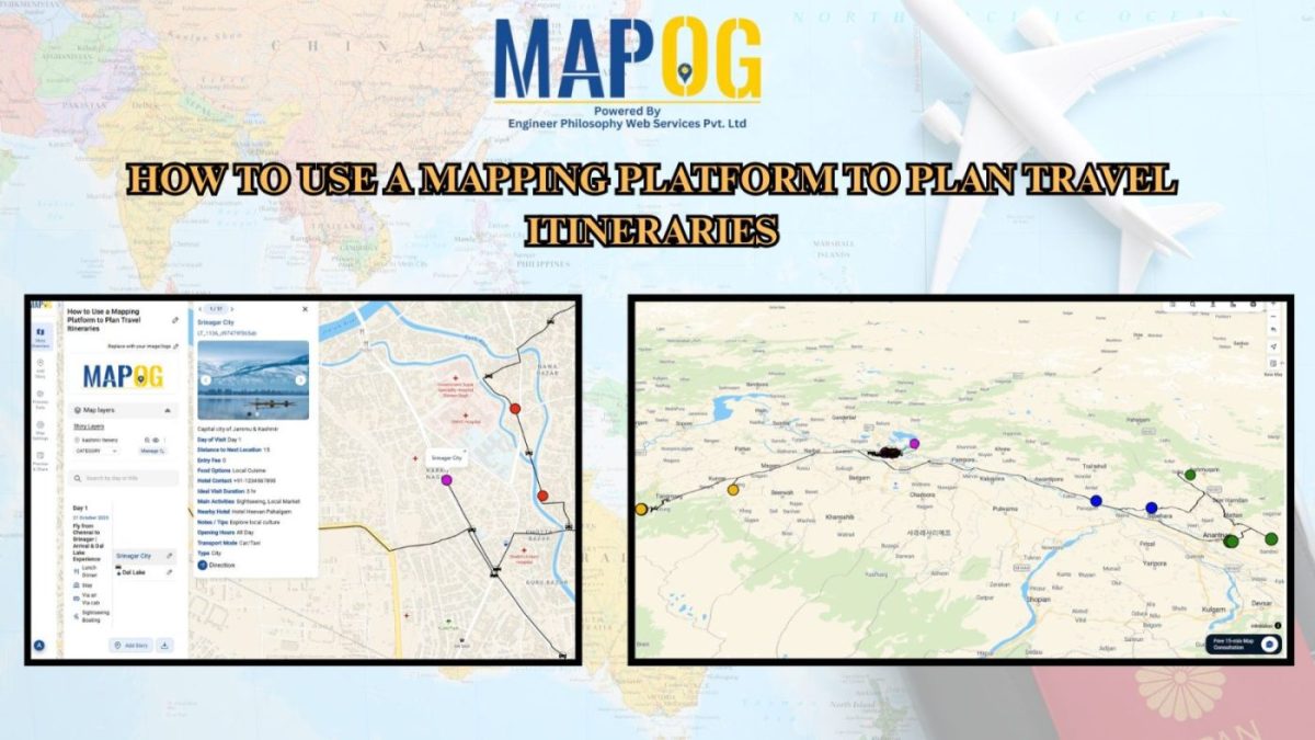
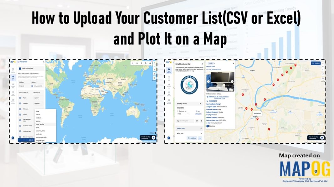
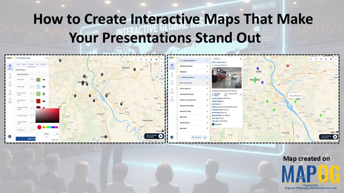
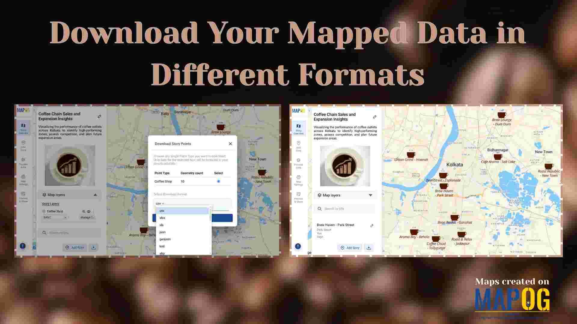
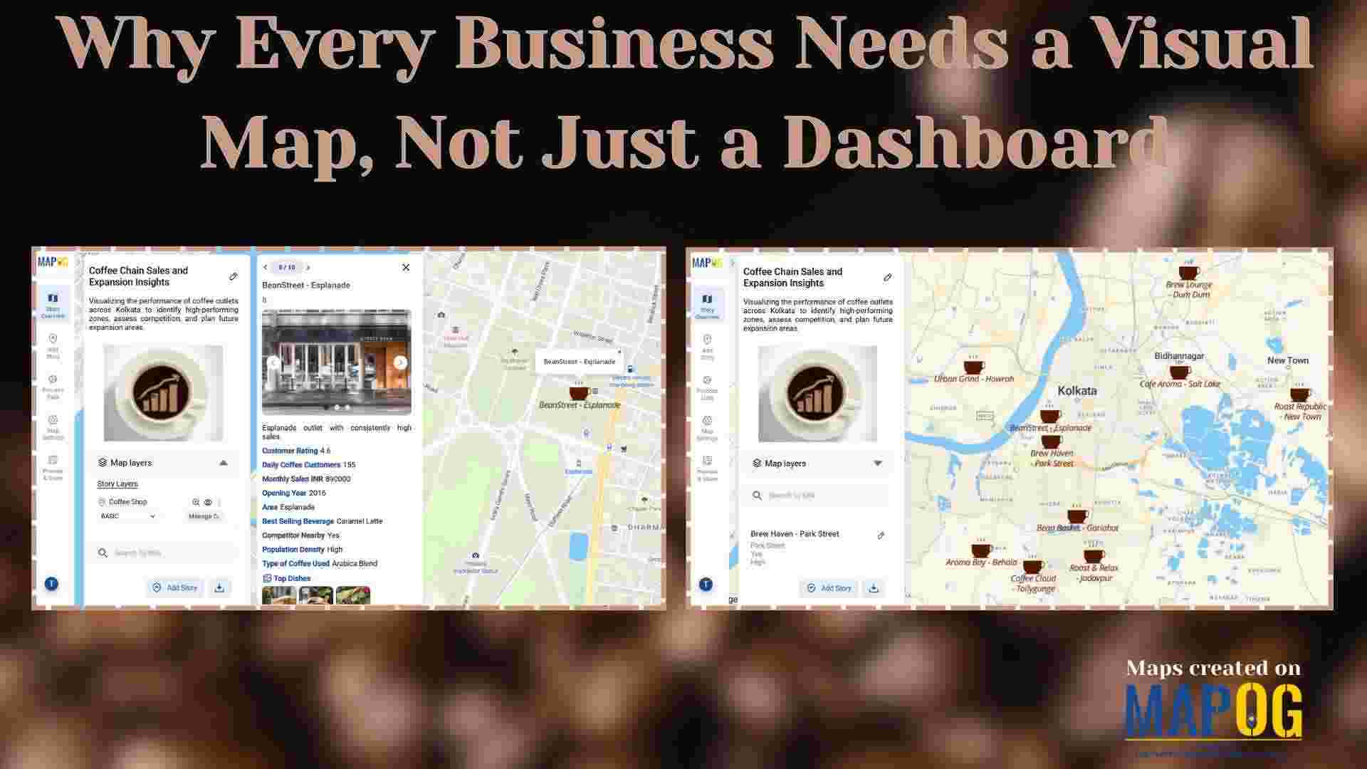
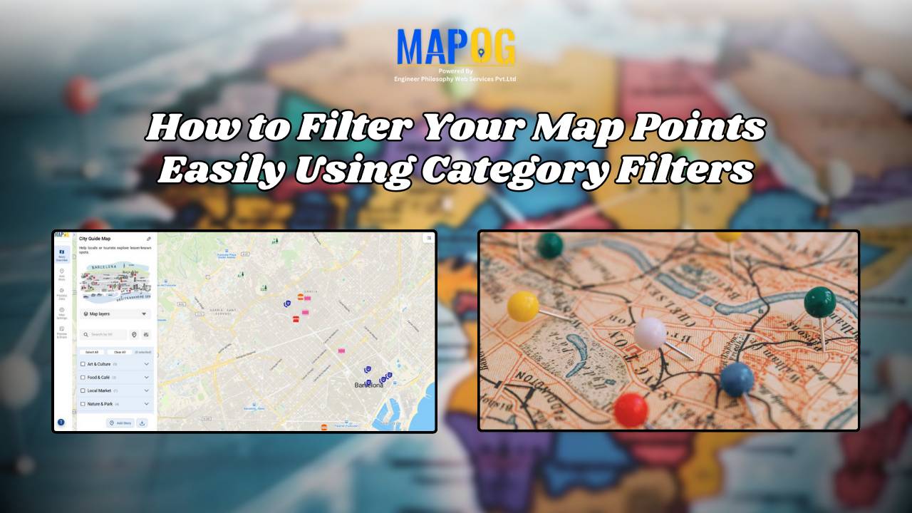
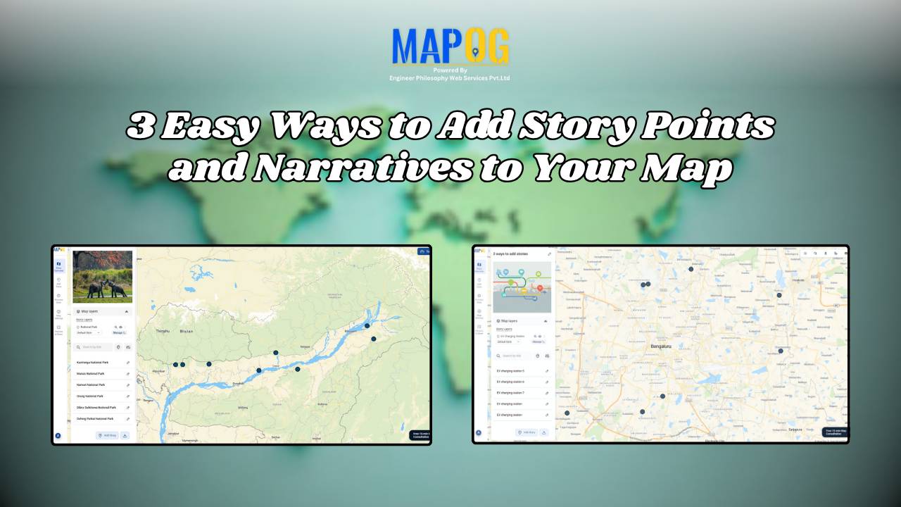
Point data

How to Map EV Charging Stations Using GIS: A Step-by-Step Guide

Mapping EV charging stations is a crucial step for planners aiming to develop smart, data-driven electric vehicle infrastructure. As electric mobility accelerates, GIS platforms like MAPOG enable users to visualize charging station locations clearly, identify gaps in coverage, and prioritize investments. Consequently, using modern web-based mapping tools, planners and analysts transform spreadsheets into actionable maps—showing … Read more

Journey Through India’s Ancient Gurukulas Mapping the Oldest Learning Centers

Journey Through India’s Ancient Gurukulas : Mapping the Oldest Learning Centers

India has long been recognized as a cradle of knowledge and wisdom. Indeed, the foundations of education were laid centuries ago through a unique and immersive learning system known as the ashram. Rooted in the ancient Vedic tradition, ashrams were not merely centers of education; rather, they served as spiritual havens where students lived alongside … Read more

Mapping Top National Parks: Preserving Nature

Mapping Top National Parks: Preserving Nature

Mapping Top National Parks play a vital role in conserving biodiversity and protecting natural landscapes while offering recreational opportunities that connect people with the environment. Additionally, these protected areas serve as sanctuaries for endangered species, geological wonders, and cultural heritage. From towering mountain ranges to vast desert expanses, national parks also support sustainable tourism, scientific … Read more

Greatest Invention Across the World - A story Map

Greatest Inventions Across the World – A Story on the Map

Human history is full of brilliant inventions that changed how we live, communicate, travel, and think. In this Greatest Inventions on Map story, we explore where these breakthroughs happened and how they shaped the world. What if you could explore these game-changing innovations visually?With Story by MAPOG, we created an interactive map showcasing 10 groundbreaking … Read more

GIS helps in solar energy site suitability and analysis

How GIS helps in Solar Energy Site Suitability and Analysis

In today’s renewable energy movement, GIS helps in solar energy site suitability and analysis by providing precision, clarity, and data-driven decisions. This blog unpacks how Geographic Information Systems are transforming how we identify optimal solar farm locations, ensuring both efficiency and environmental harmony. Through a practical example using real GIS tools, you’ll discover how layered … Read more

How to use GIS for Soil Mapping and Crop Monitoring

GIS is crucial in agriculture for soil mapping and crop monitoring, enabling informed decisions to improve yield, optimize land use, and ensure sustainable farming. It helps identify soil types, track crop density, and enhance precision farming by processing and visualizing soil and crop data. Key Concepts in GIS for Soil Mapping and Crop Monitoring GIS … Read more

HOW GIS CAN HELP IN REDUCING URBAN HEAT ISLANDS WITH SMART MAPPING

How GIS and Smart Mapping Reduce Urban Heat Islands

GIS for Heat Island Reduction enables smart mapping to analyze temperature variations identify heat-prone areas, and optimize green spaces. It supports strategic tree planting, reflective surfaces, and heat-resistant materials. GIS-driven data aids urban planners in designing cooler, sustainable cities with improved land use, reducing heat retention and energy consumption. Key Concept: GIS for heat island … Read more

Facilitating warehouse location selection

Optimizing Warehouse Location Selection with GIS for Supply Chain Efficiency

GIS optimizes supply chains and logistics by enabling precise route planning, fleet tracking, warehouse Site Selection, Demand Forecasting, and Risk Assessment. It enhances inventory management, facilitating warehouse location selection, reduces transportation costs, improves delivery efficiency, and supports data-driven decision-making, ensuring streamlined operations, better resource utilisation, and improved customer satisfaction across supply networks. Key Concept in … Read more

Role of GIS In Irrigation Planning and Water Resource Management

Role of GIS In Irrigation Planning and Water Resource Management

GIS plays a vital role in irrigation planning and water resource management by optimising site selection, assessing water demand, designing irrigation networks, and analysing crop suitability. Additionally, it enhances decision-making through spatial analysis, monitors water distribution, prevents water logging, and integrates data for sustainable and efficient water resource utilisation. Key Concept in Monitoring GIS in … Read more

How to Geocode Excel Data and Create an Interactive Map (Step-by-Step Guide)

Have a spreadsheet full of addresses or coordinates and wondering how to plot them on a map? Geocoding Excel data into an interactive map can transform raw location information into valuable insights. Whether for business analysis, logistics, or research, mapping your Excel data helps visualize trends and make data-driven decisions. This guide will walk you … Read more