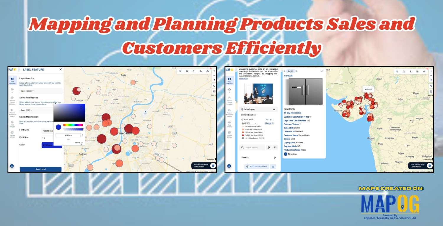
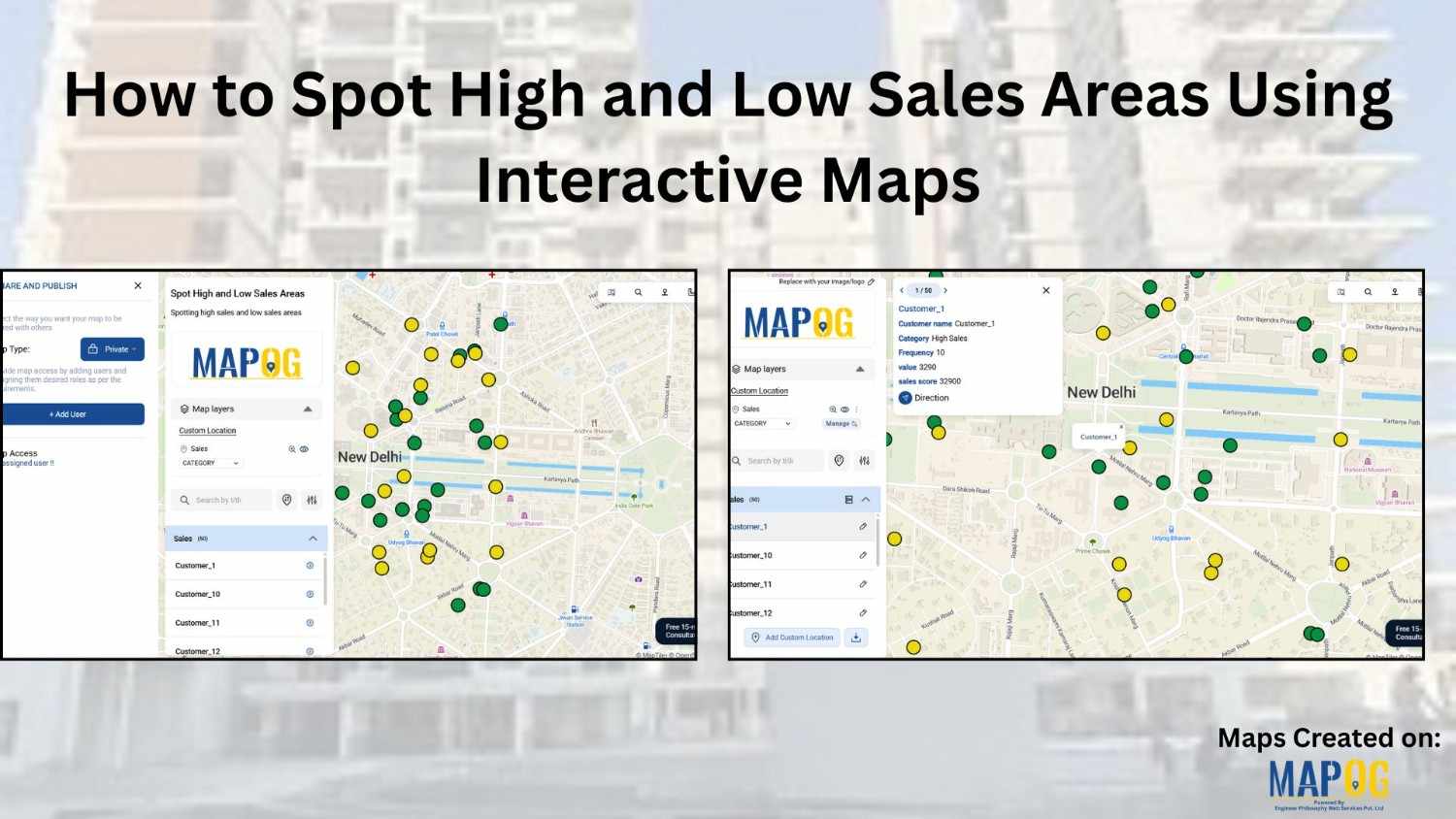
#InteractiveMaps

How to Showcase Your Hotel with an Interactive Property Map for Better Guest Engagement

When travelers look for a luxury stay, undoubtedly, visuals play a powerful role in influencing their decision. This is where you can showcase your hotel with Interactive Property Map to highlight not only your rooms but also the real advantage of your location. Moreover, by designing an engaging map with MAPOG, hotels can transform their … Read more

Hotel Campus Map for Guests Visualize Amenities, Dining, Pools, and Activities

Hotel Campus Map: How to Create an Interactive Guide to Amenities, Dining & Activities for Better Guest Experience & Operations

In modern hospitality, a Hotel Campus Map ensures great experiences aren’t just delivered—they’re mapped. Static floor plans and printed brochures no longer give guests the clarity or convenience they expect. As a result, hotels are now using Hotel Campus Map to showcase facilities—from pools and restaurants to rooms and event spaces—visually and in real time.—from … Read more

How to Map Destination Wedding Venues with Photos & Details

How to Map Destination Wedding Venues with GIS: Interactive Planning, Travel Insights & Venue Storytelling

How to map Destination weddings venues. It combine travel, culture, and celebration into one unforgettable experience, finding facilities like hospitals, and even explore different styles. In addition, this approach promotes better decision-making, while simultaneously inspiring new ideas and allowing for interactive exploration of venues. Moreover, by integrating GIS tools like MAPOG with venue data, wedding … Read more

How to Map Crops Online: Step-by-Step Guide for Farmers, Planners, and Researchers

Mapping crops on a map platforms provides an effective way to categorize, analyze, and visualize agricultural data. By organizing crop information into clear layers, farmers, planners, and researchers can better understand agricultural trends and regional strengths. This method not only helps in identifying where each crop thrives but also supports long-term planning, monitoring, and sharing … Read more

How to Use GIS Mapping for Solar Development A Step-by-Step Guide to Smart Site Selection

How to Use GIS Mapping for Solar Development: A Step-by-Step Guide to Smart Site Selection

Planning utility-scale Solar Site Suitability Mapping projects with MAPOG involves overlaying layers like GHI, land parcels, flood zones, and transmission lines. Spatial filters quickly eliminate unsuitable areas, helping prioritize sites that are both high in solar potential and accessible to the grid streamlining smart, data-driven solar development. Key Concept: Solar Site Suitability Mapping While many … Read more

Country Wise UNESCO Guide: Top Heritage Spots on a Map

Create Countrywise UNESCO Map: Top Heritage Spots Guide

Create a country-wise UNESCO Guide Map that highlights both cultural brilliance and natural wonders. On the other hand, by integrating GIS tools, this project enhances public awareness, encourages responsible tourism, and supports heritage preservation. It offers users an educational and immersive storytelling experience that makes exploring global heritage sites more accessible, insightful, and engaging. Key … Read more

Embedding Maps Boosts Website Engagement: Real Estate Agents

Embedding Maps Boosts Website Engagement: Real Estate Agents

In today’s competitive digital marketplace, real estate agents are increasingly turning to interactive tools to stand out and better serve their clients. One of the most impactful tools in this space is an embedded map. By leveraging Geographic Information Systems (GIS), agents can provide rich, interactive experiences that go far beyond static listings. Through this … Read more

Mapping Noise Pollution Levels in Cities Using Heat Maps and Buffer Tools

Mapping Noise Pollution Levels: Using Heat Maps and Buffer Tools

Noise pollution is an increasingly critical yet often overlooked environmental challenge. In urban areas, it stems primarily from traffic, construction, railways, and industrial activities. Fortunately, with the rise of Geographic Information Systems (GIS) especially tools like heat maps and buffer zones for Mapping Noise Pollution Levels. We can now visualize these invisible pollutants. As a … Read more

Mapping Top National Parks: Preserving Nature

Mapping Top National Parks: Preserving Nature

Mapping Top National Parks play a vital role in conserving biodiversity and protecting natural landscapes while offering recreational opportunities that connect people with the environment. Additionally, these protected areas serve as sanctuaries for endangered species, geological wonders, and cultural heritage. From towering mountain ranges to vast desert expanses, national parks also support sustainable tourism, scientific … Read more

How GIS Helps in Monitoring Climate Change and Its Impact

How GIS is Transforming Climate Change Monitoring and Impact Analysis

GIS (Geographic Information Systems) plays a critical role in tracking, analyzing, and visualizing the climate change and its impact. By integrating satellite imagery, environmental sensors, and spatial data, GIS enables scientists, policymakers, and environmental organizations to understand complex climate patterns and their effects on ecosystems and human communities. It supports long-term monitoring, predictive modeling, and … Read more