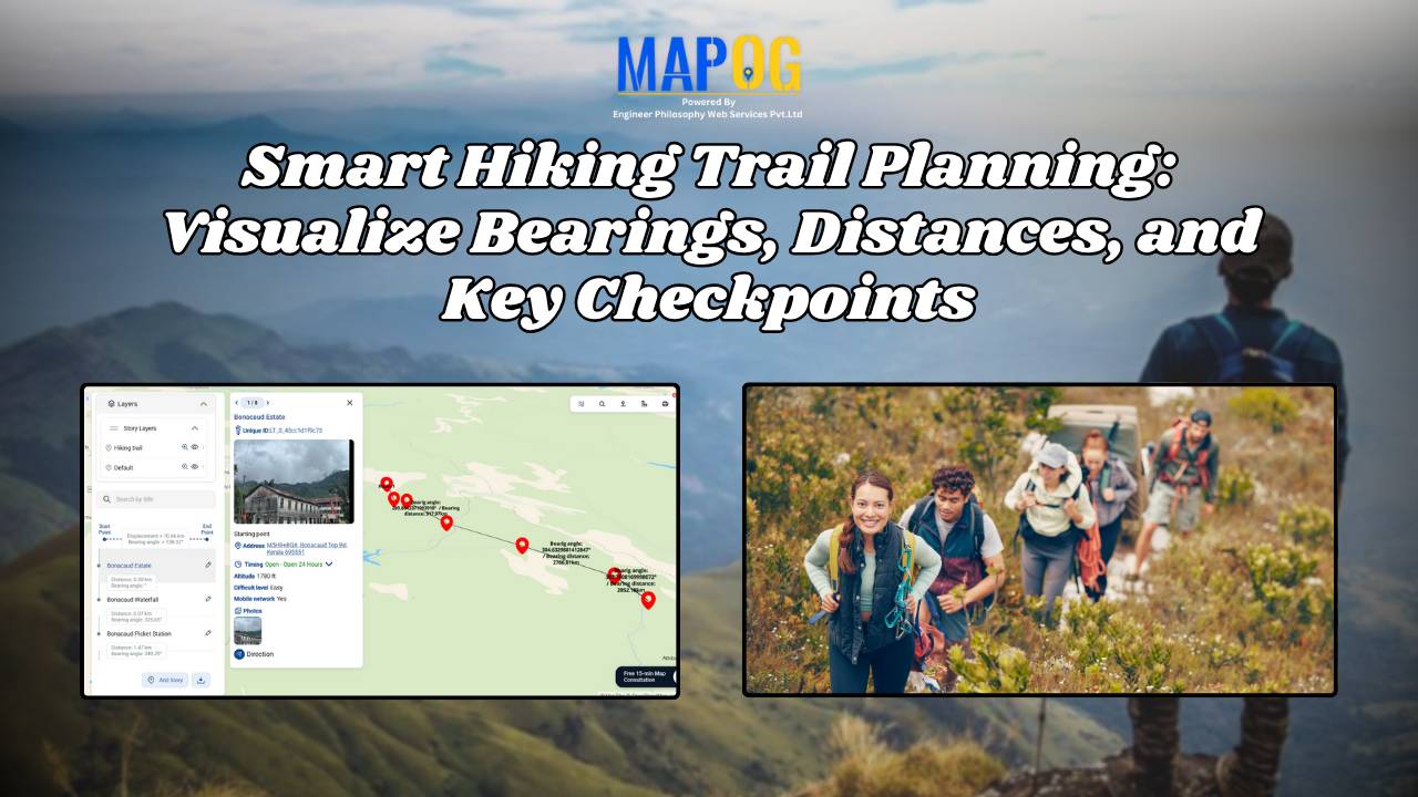
GISdata

Mapping Cyclone Shelter Locations for Coastal Safety Using GIS

Mapping Cyclone Shelter Locations for Coastal Villages Using GIS

Mapping Cyclone Shelter Locations in coastal villages need quick access to shelters during emergencies. Visualizing shelter locations and their accessibility helps uncover gaps in disaster readiness. With MAPOG, users can build interactive GIS maps showing shelter distribution, village settlements, roads, and key geographic features. Instead of complex tools, this method uses simple layers and spatial … Read more

Create a map Fire Stations to Industrial Areas: Mapping Using GIS Tools

In rapidly growing cities, fire safety is critical—particularly in industrial zones, where risk is high and emergency response must be quick. Moreover, fire stations in industrial areas play a key role in reducing disaster response time. This project uses MAPOG, a cloud-based spatial mapping platform, to visualize and analyze coverage gaps in fire response infrastructure. … Read more

Create Map of Sewage Lines and Water Cross-points for Urban Infra Projects

In urban planning, mapping sewage lines and water isn’t just about locating pipelines—it’s about understanding how systems connect and where they fall short  Therefore, as cities expand, planners need clear ways to visualize the relationship between sewage networks and treatment facilities. As a result, with MAPOG, spatial data becomes actionable insight. Mapping sewage and drainage … Read more

How Real Estate Agents Use Maps to Sell Properties Smarter

How Real Estate Agents Use Maps to Sell Properties Smarter

In real estate, using real estate map tools helps agents present not just the property, but its location benefits too. More agents now use interactive maps to help buyers understand not just the home, but its surroundings—like nearby parks, schools, transit, and conveniences. Embedding maps into property listings makes websites more engaging. When buyers can … Read more

Create a Travel Journal on a Map – Add Photos, Notes & Pins

Create a Travel Journal on a Map – Add Photos, Notes & Pins

Planning your next adventure? Don’t just jot down your stops—Create a Travel Journal on a Map to capture every moment. A Travel Journal Map helps you organize memories by location, add photos and notes, and visually share your journey. With MAPOG, it’s easy to plan your route, add key locations, and share it online with … Read more

GIS Mapping of Landslide

GIS Mapping of Landslide-Prone Villages and Road Accessibility

In recent years, the importance of GIS Mapping of Landslide-prone areas has grown significantly. As climate conditions continue to worsen and extreme weather becomes more frequent, it is becoming increasingly critical to assess not only the vulnerable zones but also how surrounding communities and nearby roads can be affected. Consequently, this blog will walk you … Read more

GIS Mapping Public Service

How GIS Mapping Optimizes Public Service Delivery in Municipalities

In today’s data-driven world, GIS Mapping Optimizes Public Service Delivery by transforming how cities manage essential services. MAPOG help planners visualize, analyze, and optimize infrastructure such as waste management, healthcare, and safety. With targeted layers like Public Health Maps and tools to Map EV Charging Stations, cities address both core needs and sustainability goals. As … Read more

Performing Retail Site Selection with Convex Hull Analysis

Performing Retail Site Selection with Convex Hull Analysis

Choosing the right retail location goes beyond guessing where people shop. Instead it’s about recognizing spatial clusters, identifying market gaps, and optimizing coverage. With this in mind, MAPOG, retailers can make data-driven decisions by interpreting customer and store distributions visually. Coupled with heat bubble styling, grid-based analysis, or retail site selection , MAPOG enables smarter … Read more

Mapping Waste Disposal Sites with GIS for Clean Cities

In fast-growing cities, mapping waste disposal sites with GIS is becoming essential to public health and sustainability. As waste volumes rise, understanding where and how it’s managed is key to building cleaner, more efficient cities. This project uses MAPOG, a cloud-based spatial mapping platform, to visualize key waste disposal sites—ranging from major landfills to Refuse … Read more

Free GIS Mapping Tools for Students and Researchers

Free GIS Mapping Tools for Students and Researchers

In today’s logistics-driven world, Geographic Information Systems (GIS) play a pivotal role in analyzing spatial data for informed decision-making. Fortunately, MAPOG offers Free GIS Mapping Tools that empower students, researchers, and planners to explore and visualize real-world location-based patterns. With tools such as Buffer Zones, Clip and Isochrones, users can easily identify optimal sites for … Read more