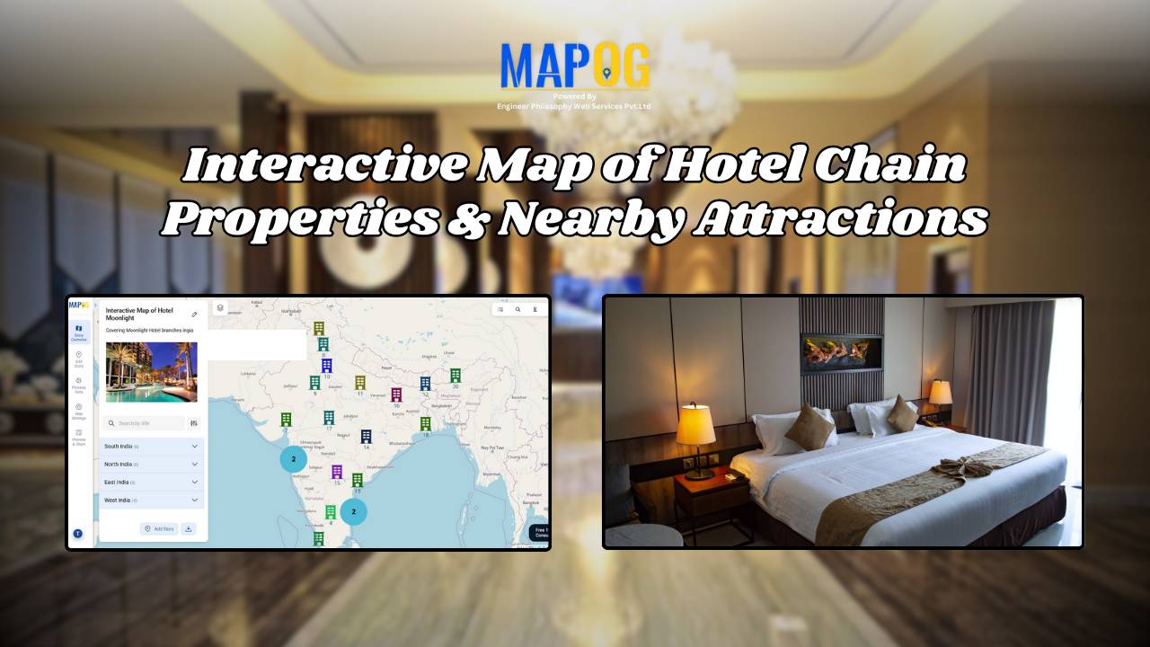
MAP STORY

How to Map Crops Online: Step-by-Step Guide for Farmers, Planners, and Researchers

Mapping crops on a map platforms provides an effective way to categorize, analyze, and visualize agricultural data. By organizing crop information into clear layers, farmers, planners, and researchers can better understand agricultural trends and regional strengths. This method not only helps in identifying where each crop thrives but also supports long-term planning, monitoring, and sharing … Read more

electric aerial vehicle routes

How to Plan Efficient Electric Aerial Vehicle Routes Using Bearing Angle and Distance

Planning efficient electric aerial vehicle routes is, therefore, becoming essential in industries like logistics, disaster response, and surveillance. Not only does a precise route save time, but it also ensures flight safety and energy optimization. Consequently, MAPOG simplifies this process by combining bearing angle & distance calculations with real-world coordinates. In this article, we’ll explore … Read more

Mapping History with GIS: Turn Historical Events into Interactive Stories

Historical events have, over centuries, shaped civilisations and cultures. Consequently, mapping history with GIS tools provides new insights into how past events unfolded geographically. As a result, this promotes deeper engagement, improves retention, and simultaneously encourages an immersive way of exploring timelines and stories. Moreover, by integrating GIS tools with historical data, storytelling becomes more … Read more

How to Map Waste Disposal Sites Near Residential Areas Using GIS Buffer Analysis

In today’s expanding urban landscapes, Mapping Waste Disposal Sites and the safe management of waste is a growing concern for both communities and city planners. Improperly placed waste disposal sites can pose serious health and environmental risks, especially when located too close to residential areas. Issues such as air and water pollution, unpleasant odors, and … Read more

Mapping Military Flight Paths

Mapping Military Flight Paths: How GIS Helps Calculate Distance and Bearing Angles

Mapping Military Flight Paths is a crucial component in modern aerial defense planning. With the continuous rise of geographic intelligence, GIS technology now plays a central role in not only plotting accurate coordinates but also in calculating distances and determining precise bearing angles. This process, therefore, goes far beyond simply drawing lines on a map—it … Read more

How to Map and Manage a Franchise Business with Location and Service Filters

If you’re planning to expand your food chain or track multiple branches across cities, then learning how to map a franchise business with smart filters is a true breakthrough. By doing so, you can visualize store data on an interactive platform, which in turn helps you easily organize locations, services, and customer insights. Whether you’re … Read more

How to Use GIS Mapping for Solar Development A Step-by-Step Guide to Smart Site Selection

How to Use GIS Mapping for Solar Development: A Step-by-Step Guide to Smart Site Selection

Planning utility-scale Solar Site Suitability Mapping projects with MAPOG involves overlaying layers like GHI, land parcels, flood zones, and transmission lines. Spatial filters quickly eliminate unsuitable areas, helping prioritize sites that are both high in solar potential and accessible to the grid streamlining smart, data-driven solar development. Key Concept: Solar Site Suitability Mapping While many … Read more

Mapping Cyclone Shelter Locations for Coastal Safety Using GIS

Mapping Cyclone Shelter Locations for Coastal Villages Using GIS

Mapping Cyclone Shelter Locations in coastal villages need quick access to shelters during emergencies. Visualizing shelter locations and their accessibility helps uncover gaps in disaster readiness. With MAPOG, users can build interactive GIS maps showing shelter distribution, village settlements, roads, and key geographic features. Instead of complex tools, this method uses simple layers and spatial … Read more

Urban Flood Hotspots Mapping

Create Map for Urban Flood Complaint Hotspots and Shelter Accessibility 

In today’s rapidly growing cities, climate change and infrastructure weaknesses have made urban flooding a significant challenge for communities and city planners alike. During heavy rain or storms, certain areas become prone to waterlogging, flood risks, and complaints, putting nearby properties and people at risk. At the same time, identifying high-risk zones and nearby shelters—and … Read more

How GIS on Map Helps Optimize Public Transport Routes and Reduce Traffic

In today’s urban landscape, GIS for public transport optimisation is basically transforming how cities tackle congestion and improve mobility. By integrating spatial data with transit planning altogether, Geographic Information Systems help planners design smarter, more efficient transport routes that reduce traffic, improve accessibility, and enhance commuter satisfaction. Understanding GIS for Public Transport Optimization and Why … Read more