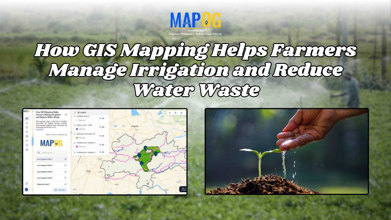
GISdata

GIS Tool for Organic Farming

Using GIS Tools to Identify Best Sites for Organic Farming and Increase Yield

With the rise of sustainable agriculture, organic farming meanwhile emerges as a key method for eco-friendly food production. However, its long-term success depends, above all, on precise site selection. Fortunately, with the help of a GIS Tool for Organic Farming, such as MAPOG, users can seamlessly adopt Smart Farming with GIS. Moreover, by seamlessly layering … Read more

Map River and Road Intersections for Environmental Analysis

Create a Map of River and Road Intersections for Environmental Analysis

To begin with, understanding the intersection between rivers and road networks is essential for effective environmental planning and risk management. In particular, these road and river intersections can indicate areas vulnerable to flooding, erosion, or pollution. By doing so, urban planners, environmental analysts, and disaster response teams to make data-driven decisions that improve sustainability and … Read more

The Ultimate Guide to Uploading GIS Data Formats (CSV, KML, Shapefile)

Uploading GIS data is the crucial first step in any spatial analysis workflow. Whether for urban planning, environment, infrastructure, or disaster response, clean and structured data ensures accuracy in representing real-world features and relationships. Using correct formats allows mapping software to interpret boundaries and attributes effectively. MAPOG, a leading cloud-based GIS platform, supports various formats … Read more

Create Map to Identify Groundwater Decline and Recharge Gaps Using GIS Tools

Groundwater mapping using GIS tools is becoming essential as groundwater decline and recharge gaps raise serious concerns—especially in regions that rely heavily on underground water resources. Fortunately, by using GIS technology, stakeholders can now visualize, Role of GIS In Irrigation Planning and Water Resource Management to these changes more efficiently than ever before. Moreover, with … Read more

How to Map and Share Retail Store Locations for Your Franchise?

In today’s data-driven world, the ability to map retail store locations for your franchise is one of the smartest moves you can make. Just as visualizing a Safari Itinerary on a map helps travelers craft immersive and efficient journeys, or mapping Spatial Retail Store Analysis with GIS tools enables cities to improve safety and planning, … Read more

Interactive Population Maps

Interactive Population Map with Heat Bubble and Category Styling

Analysing and interpreting population data across various geographic regions can be done visually with Interactive Population Maps with Heat Bubble and Category Styling. It is simple to quickly identify high and low concentration areas on these maps because they use heat bubbles, which vary in size and colour, to represent population density or totals. Furthermore, … Read more

Interactive Property Hunt Map

How to Organise Your Property Hunt: Pin Live Locations, Add Photos, and Manage All Details on One Interactive Map

Searching for a new home can be both exciting and overwhelming. With endless property listings, scattered notes, and various amenities to consider, it’s easy to feel lost in the process. That’s where an Interactive Property Hunt Map becomes a game-changer. By using smart tools like MAPOG, you can visually organize your entire home search—pinning property … Read more

“A digital map highlighting water-scarce villages and nearby water sources in India using GIS tools, illustrating buffer zones, village boundaries, and water infrastructure.”

GIS-Based Mapping of Water-Scarce Villages and Nearest Water Sources

Water scarcity continues to challenge many rural areas across India. With shifting climate patterns, population pressures, and the overuse of natural resources, numerous villages face both seasonal and long-term water stress. However, Mapping Groundwater Concentration through GIS presents a powerful approach to this issue. By visualizing the availability and distribution of subsurface water, it becomes … Read more

How to Create Map, Share, and Embed Your Retail Business Locations

How to Create Map, Share, and Embed Your Retail Business Locations

In today’s hyper-connected marketplace, visibility is everything—and digital maps are becoming essential tools for retail success. Mapping, sharing, and embedding your retail store locations using  MAPOG enables business owners and marketers to showcase their store presence with clarity and precision. Whether you operate a single boutique or a nationwide chain, geospatial tools help you Visualise, … Read more

GIS in Identifying High-Growth Areas for Real Estate Investment

GIS in Identifying High-Growth Areas for Real Estate Investment

In today’s fast-evolving urban landscape, identifying the right location for real estate investment is both a science and a strategy. GIS helps in Identifying High-Growth Areas is a go-to approach for investors and planners aiming to make informed, data-backed decisions. From analyzing transportation access to mapping nearby amenities, GIS adds a new level of depth … Read more