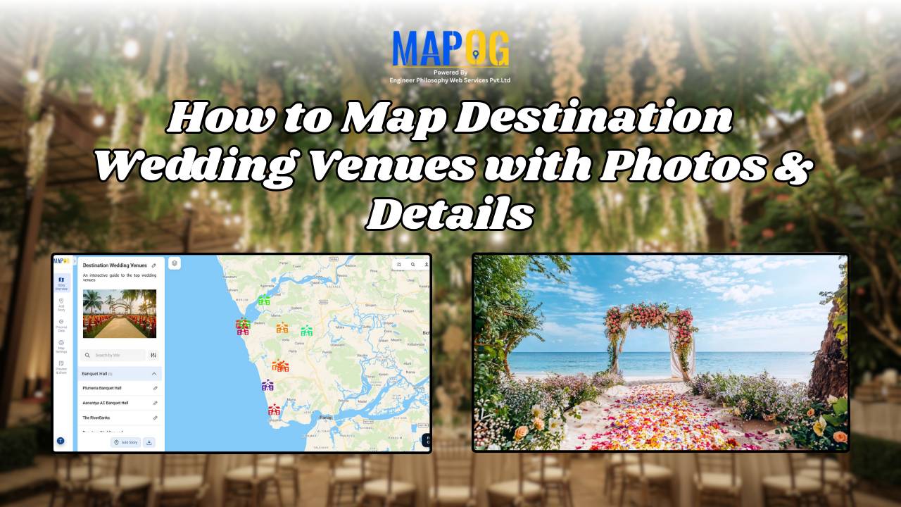
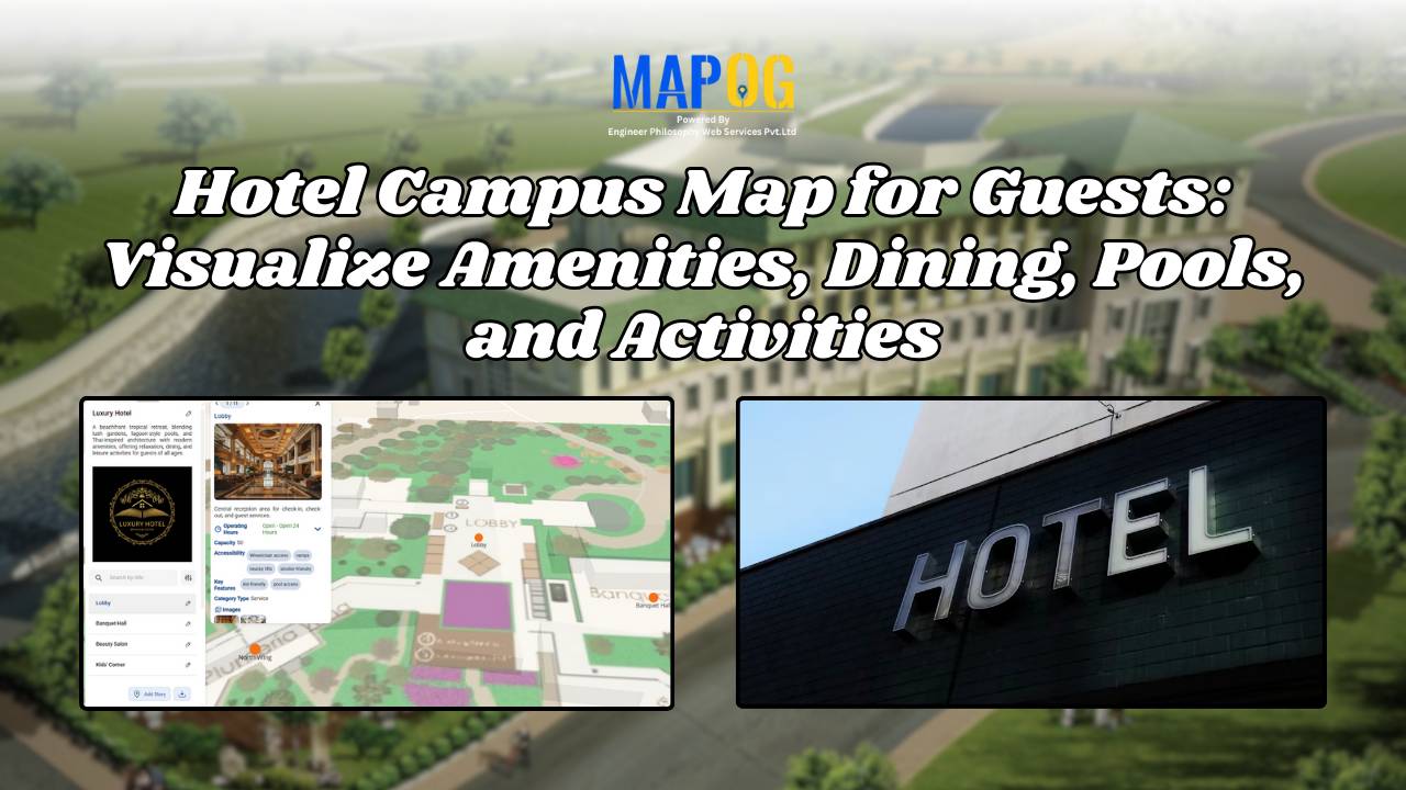
Embedded maps

How to Create a Car Delivery Map with Customer Photos & Reviews [Step-by-Step Guide]

When people buy a car, the delivery moment naturally becomes a memory worth keeping. Therefore, a Happy Customer Car Delivery Map seamlessly brings those stories together in one interactive platform. By combining delivery photos, customer names, and car details across different locations, dealerships can not only showcase their happiest moments but also strengthen trust. Moreover, … Read more

On-Map Travel Planning How to Build and Share Interactive Itineraries

On-Map Travel Planning: How to Build and Share Interactive Itineraries Transform Client Experiences

On-Map Travel Planning: How Interactive Itineraries Transform Client Experiences In modern travel , clients no longer want static itineraries—they want to see their journey unfold. Traditional PDFs and spreadsheets may list activities, but they fail to convey geography, movement, or the emotional arc of a trip. This is where on-map travel planning changes the game. … Read more

Identifying Flood Prone region and Safe Zones using GIS

How to Use GIS to Identify Flood-Prone Areas and Map Safe Zones using buffer analysi

Identifying Flood Prone region near rivers is vital for disaster preparedness. Using GIS buffer analysis, a 1 km zone around rivers highlights vulnerable settlements, enabling rapid flood-risk estimation, mapping of exposed regions, and informed mitigation planning without complex hydrological modeling. So users can build interactive flood risk maps by integrating river data, and key land-use … Read more

How to Create Interactive Real Estate Portfolio Maps: Organize, Visualize, and Showcase Projects

In real estate development, success isn’t just built—it’s mapped. Today’s developers are moving beyond static brochures to embrace tools like interactive real estate portfolio map. Hence, these dynamic tools allow developers to present their projects with clarity, connectivity, and context. For example, just as agents use maps to help homebuyers understand surroundings, developers are now … Read more

electric aerial vehicle routes

How to Plan Efficient Electric Aerial Vehicle Routes Using Bearing Angle and Distance

Planning efficient electric aerial vehicle routes is, therefore, becoming essential in industries like logistics, disaster response, and surveillance. Not only does a precise route save time, but it also ensures flight safety and energy optimization. Consequently, MAPOG simplifies this process by combining bearing angle & distance calculations with real-world coordinates. In this article, we’ll explore … Read more

Mapping Military Flight Paths

Mapping Military Flight Paths: How GIS Helps Calculate Distance and Bearing Angles

Mapping Military Flight Paths is a crucial component in modern aerial defense planning. With the continuous rise of geographic intelligence, GIS technology now plays a central role in not only plotting accurate coordinates but also in calculating distances and determining precise bearing angles. This process, therefore, goes far beyond simply drawing lines on a map—it … Read more

How to Map and Manage a Franchise Business with Location and Service Filters

If you’re planning to expand your food chain or track multiple branches across cities, then learning how to map a franchise business with smart filters is a true breakthrough. By doing so, you can visualize store data on an interactive platform, which in turn helps you easily organize locations, services, and customer insights. Whether you’re … Read more

How to Map Rental Properties with Nearby Amenities Using Interactive GIS Maps

Whether you’re a real estate agent, property manager, or investor, mapping rental properties with key nearby amenities gives your listings the edge. In fact, visual maps offer clarity, transparency, and better decision-making for both renters and owners. By combining precise coordinates with contextual data—such as distance from schools, hospitals, or parks—you ultimately make the rental … Read more

Mapping Hospital Coverage and Categories Using Convex Hull

Mapping Rural Hospital Coverage Using GIS and Convex Hull

Mapping Hospital Coverage and Categories, locations in rural areas ensures that communities have access to essential healthcare during emergencies. Visualising hospital distribution and overall coverage helps identify underserved regions and gaps in healthcare infrastructure. With MAPOG, users can build interactive GIS maps showing hospital points, health facility types, and Convex Hull polygons that represent the … Read more

How to Use GIS Mapping for Solar Development A Step-by-Step Guide to Smart Site Selection

How to Use GIS Mapping for Solar Development: A Step-by-Step Guide to Smart Site Selection

Planning utility-scale Solar Site Suitability Mapping projects with MAPOG involves overlaying layers like GHI, land parcels, flood zones, and transmission lines. Spatial filters quickly eliminate unsuitable areas, helping prioritize sites that are both high in solar potential and accessible to the grid streamlining smart, data-driven solar development. Key Concept: Solar Site Suitability Mapping While many … Read more