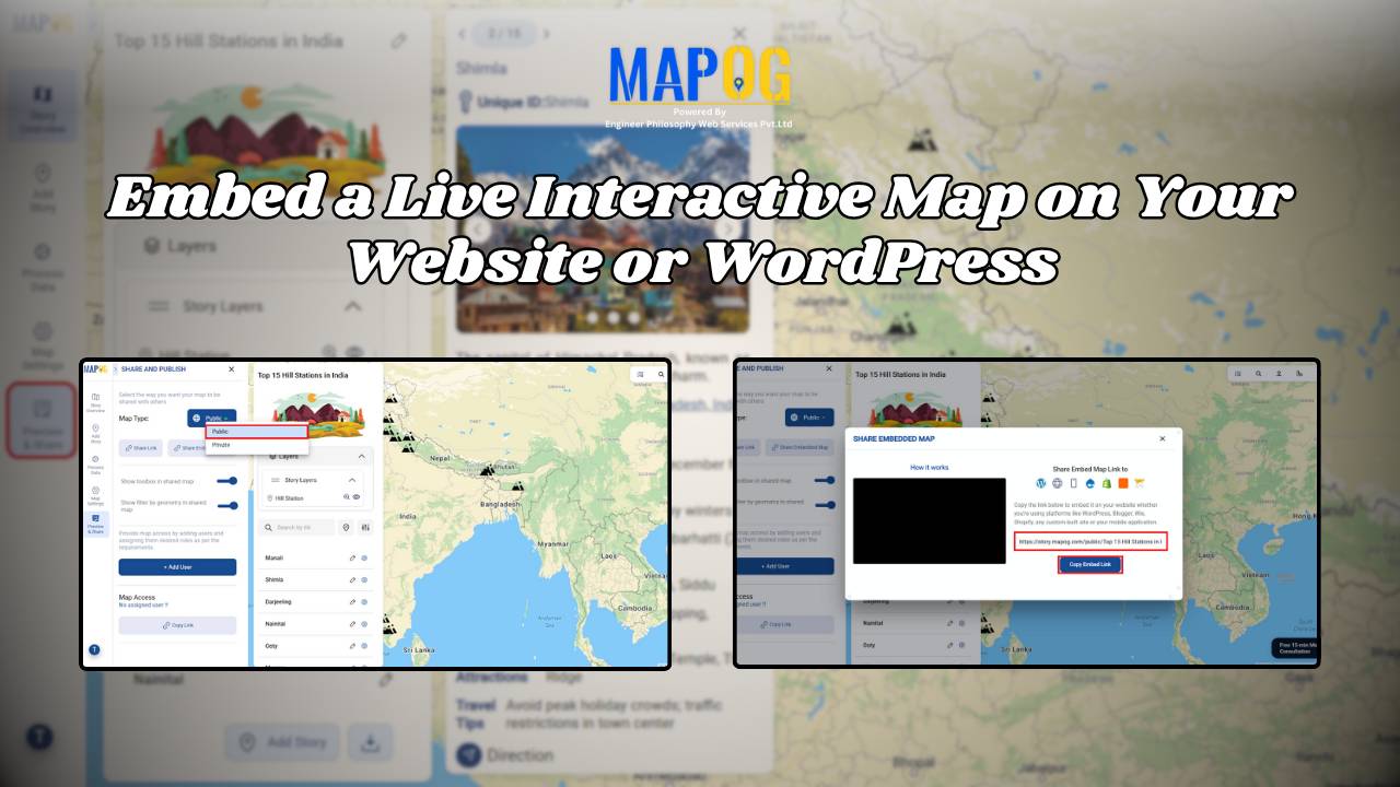
Embedded maps

How Interior Designers Can Manage Projects On-Map, Not on Spreadsheets

Managing interior design projects often feels overwhelming, especially when updates are scattered across WhatsApp chats, shared drives, and endless spreadsheets. For years, spreadsheets seemed like the go-to option; however, they usually fail to provide clarity when teams need real-time visualisation across multiple sites. That’s exactly where interactive maps step in. With MAPOG, Interior design project … Read more

How Mapping Community Water, Energy and Environmental Projects Can Drive Sustainable Development

How Interactive Maps Drive Community Water, Energy, and Environmental Projects

Sustainable development cannot be achieved without community-driven initiatives that focus on water, energy, and environmental needs. Moreover, Mapping Community Water, energy, and environmental projects offers a practical way to visualise data, highlight impact, and ensure transparency. In fact, by creating interactive maps, decision-makers, NGOs, and local communities can track project status, monitor beneficiaries, and share … Read more

How to Map Waste Bins, Collection Points & Recycling Centers to Improve Waste Management and Sustainability

How to Map Waste Bins, Collection Points & Recycling Centers to Improve Waste Management and Sustainability

Waste management is one of the most pressing urban challenges today. However, technology offers us smarter solutions. For example, when you map waste bins, collection points, and recycling centers on an interactive platform, cities can better optimize collection, reduce overflow, and encourage sustainable disposal. Moreover, MAPOG makes it simple to visualize, customize, and share such … Read more

Interactive Healthcare Map Locate Hospitals, Clinics, Diagnostic Labs & Health Centers

How to Create an Interactive Healthcare Map: Visualize Hospitals, Clinics, and Diagnostic Labs

Healthcare is vital for every community, and using an interactive healthcare map makes it easier to locate the nearest hospital, clinic, or diagnostic lab. With tools like MAPOG, it’s now possible to visualize the entire healthcare network of a city on a single platform. An interactive healthcare map makes it easy to categorize facilities, and … Read more

Smart Hospital Maps: How Interactive Mapping Improves Patient Navigation & Care

Optimizing patient care in a hospital requires a clear view of how different clinical centers, labs, and departments are distributed across the campus. Therefore, a smart hospital campus map improves visibility, efficiency, and decision-making by making navigation simple for patients, staff, and visitors. Using MAPOG, you can create an interactive hospital map that visualizes healthcare … Read more

Interactive Property Brochure- Showcase Properties with Maps

How to Turn Property Brochures into Interactive Maps for Real Estate Marketing

Interactive Map Experience is redefining real estate marketing by transforming static brochures into dynamic, engaging tools. Instead of only relying on PDFs or plain text, buyers and tenants can instantly see how a property connects to its surroundings—schools, healthcare, transit, and green spaces. These interactive maps don’t just show the building; they showcase the lifestyle … Read more

Visualize Your Entire College on an Interactive Campus Map

Interactive Campus Map: Visualize Your Entire College with Smart Digital Navigation

Visualize Your Entire College into a smart, navigable, and interactive digital hub with GIS-powered campus mapping. This modern solution allows colleges and universities to showcase their entire infrastructure—academic buildings, hostels, sports arenas, cultural centers, and even upcoming event venues—on a single interactive map. In this case students, faculty, visitors, and alumni gain instant access to … Read more

How GIS Identifies Medical Investment Hubs for Strategic Healthcare Real Estate Growth

Investing in healthcare-focused real estate requires precise Medical Investment Hubs with GIS mapping to identify prime locations near hospitals, clinics, and medical research centers. Likewise, by plotting healthcare hubs, nearby amenities, and transport access, planners and investors can ensure informed decisions, strategic growth, and community well-being using interactive maps with healthcare and property data. Key … Read more

Hotel Campus Map for Guests Visualize Amenities, Dining, Pools, and Activities

Hotel Campus Map: How to Create an Interactive Guide to Amenities, Dining & Activities for Better Guest Experience & Operations

In modern hospitality, a Hotel Campus Map ensures great experiences aren’t just delivered—they’re mapped. Static floor plans and printed brochures no longer give guests the clarity or convenience they expect. As a result, hotels are now using Hotel Campus Map to showcase facilities—from pools and restaurants to rooms and event spaces—visually and in real time.—from … Read more

How to Map Destination Wedding Venues with Photos & Details

How to Map Destination Wedding Venues with GIS: Interactive Planning, Travel Insights & Venue Storytelling

How to map Destination weddings venues. It combine travel, culture, and celebration into one unforgettable experience, finding facilities like hospitals, and even explore different styles. In addition, this approach promotes better decision-making, while simultaneously inspiring new ideas and allowing for interactive exploration of venues. Moreover, by integrating GIS tools like MAPOG with venue data, wedding … Read more