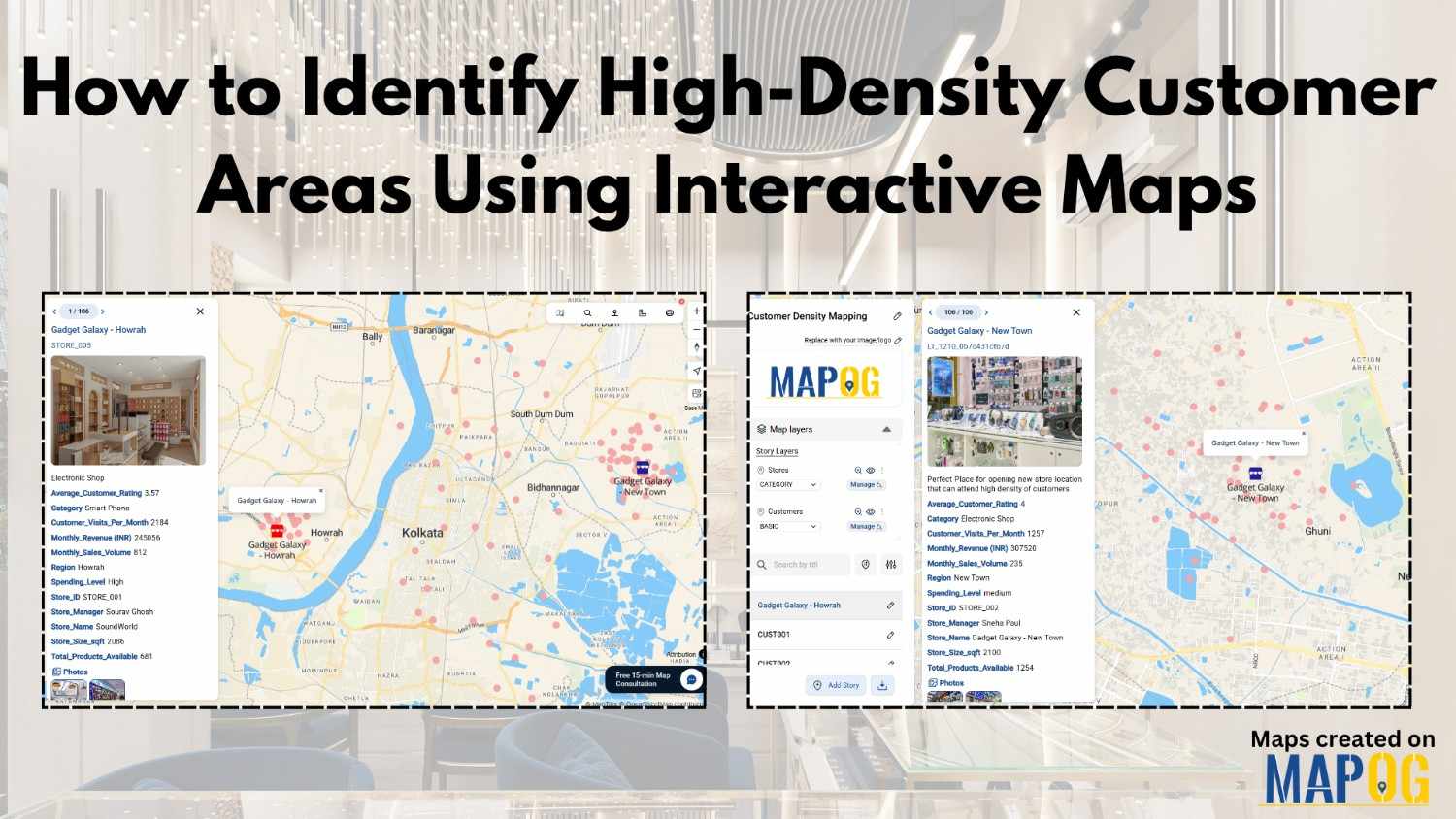
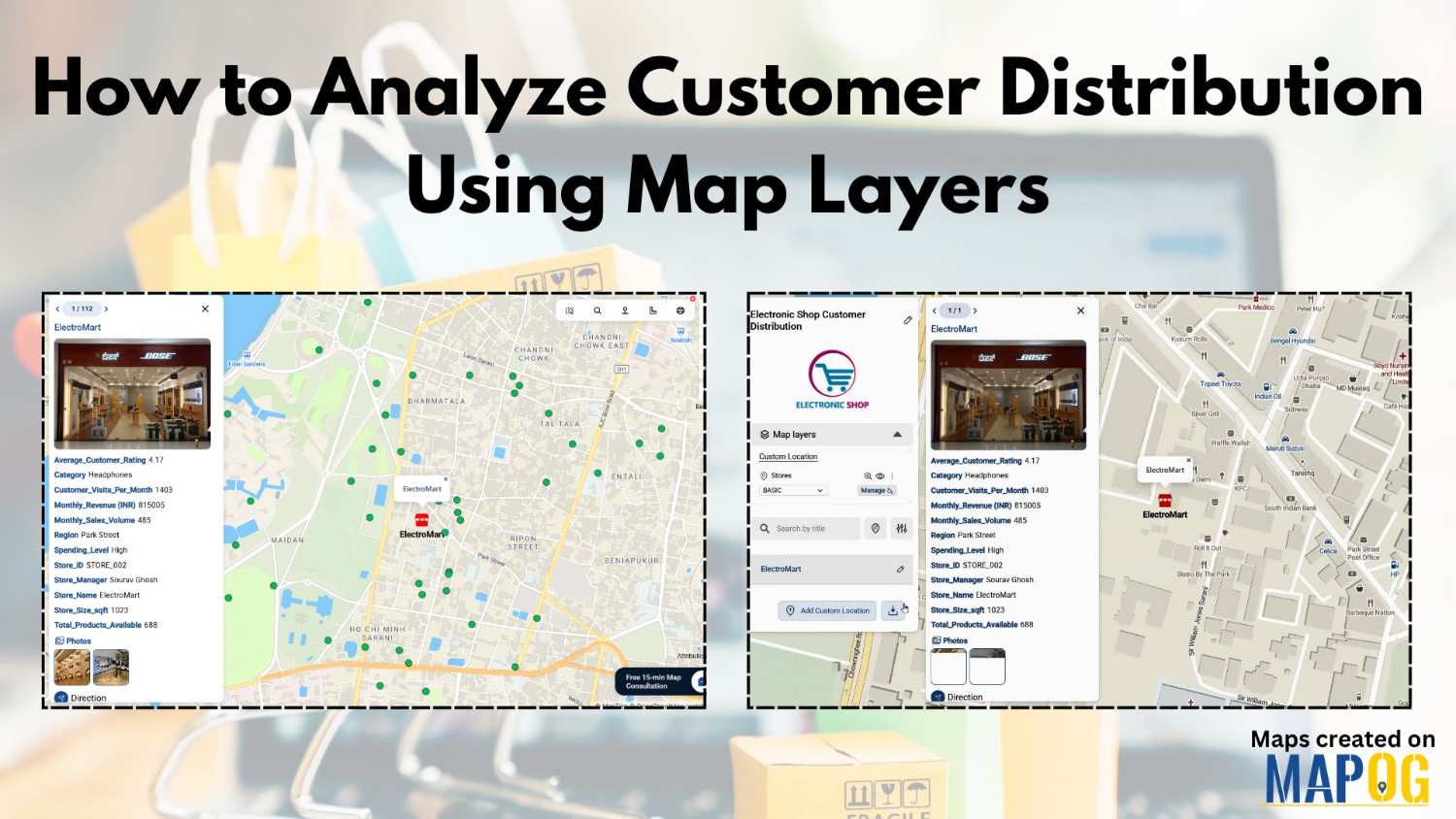
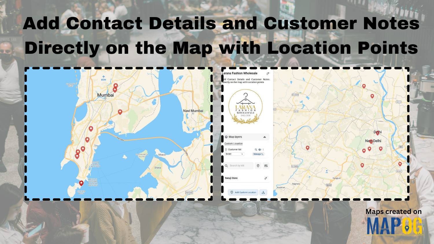
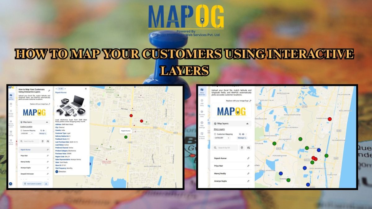
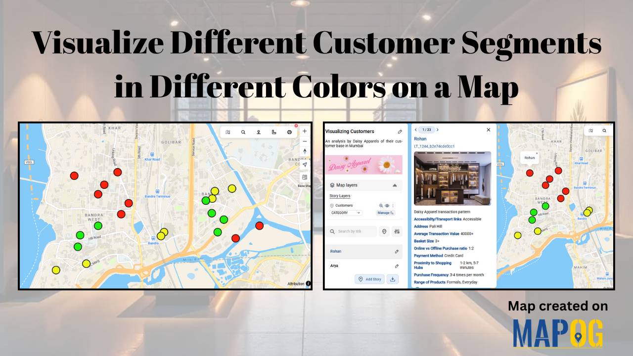
Easy Map Creation

Interactive Population Maps

Interactive Population Map with Heat Bubble and Category Styling

Analysing and interpreting population data across various geographic regions can be done visually with Interactive Population Maps with Heat Bubble and Category Styling. It is simple to quickly identify high and low concentration areas on these maps because they use heat bubbles, which vary in size and colour, to represent population density or totals. Furthermore, … Read more

“Visual map showcasing top universities categorized by popular courses such as MBA, Law, Engineering, and more”

Top Universities on Map by Popular Courses: MBA, Law, Engineering & More

In a globally connected world, students, researchers, and academic planners are increasingly turning to smart solutions for understanding how leading institutions are distributed across regions. Whether you’re exploring top engineering schools, renowned MBA programs, or historic fine arts colleges, mapping education institute places offers a dynamic and visual way to grasp academic reach and reputation. … Read more

How to Create Map, Share, and Embed Your Retail Business Locations

How to Create Map, Share, and Embed Your Retail Business Locations

In today’s hyper-connected marketplace, visibility is everything—and digital maps are becoming essential tools for retail success. Mapping, sharing, and embedding your retail store locations using  MAPOG enables business owners and marketers to showcase their store presence with clarity and precision. Whether you operate a single boutique or a nationwide chain, geospatial tools help you Visualise, … Read more

Country Wise UNESCO Guide: Top Heritage Spots on a Map

Create Countrywise UNESCO Map: Top Heritage Spots Guide

Create a country-wise UNESCO Guide Map that highlights both cultural brilliance and natural wonders. On the other hand, by integrating GIS tools, this project enhances public awareness, encourages responsible tourism, and supports heritage preservation. It offers users an educational and immersive storytelling experience that makes exploring global heritage sites more accessible, insightful, and engaging. Key … Read more

Clean Cities in India: Mapping with a GIS Perspective

Clean Cities in India: Mapping with a GIS Perspective

Mapping Clean Cities in India is a GIS Perspective which explores how geospatial tools turn sanitation rankings into spatial insight. As India’s cities evolve, sustainability—and cleanliness in particular—has become central to public health and urban development. When evaluating the cleanest city in India, Swachh Survekshan survey offers annual rankings, the “where” behind success often goes … Read more

How to create Major Historical Battles and War Sites Map

History isn’t just about events it’s about where they happened. From ancient conquests to world wars, every major battle unfolded on a map. In this guide, we’ll walk through how to build a stunning “Historical Battles and War Sites” story map using MAPOG. you can transform history into an interactive journey by creating a “Major … Read more

Create an Online Map to Visualize and Collaborate on the 7 Wonders of the World

Learn geography & history by creating an interactive map that highlights the 7 Wonders of the World.

Discover geography and history by creating an interactive map of the 7 Wonders of the World—ideal for students, educators, and explorers. These iconic sites highlight human creativity, engineering, and cultural identity, each reflecting the unique legacy of its civilization. Using Geographic Information Systems (GIS), you can combine geography, history, and travel planning into an engaging … Read more

How to Map EV Charging Stations Using GIS: A Step-by-Step Guide

Mapping EV charging stations is a crucial step for planners aiming to develop smart, data-driven electric vehicle infrastructure. As electric mobility accelerates, GIS platforms like MAPOG enable users to visualize charging station locations clearly, identify gaps in coverage, and prioritize investments. Consequently, using modern web-based mapping tools, planners and analysts transform spreadsheets into actionable maps—showing … Read more

Travel Route Planning Made Simple with Story Maps

Travel Route Planning Made Simple with Story Maps, Story maps are a creative way to integrate storytelling and geographic data, enabling users to see events, experiences, and manage plans on an interactive map combine narrative text, multimedia, and maps to produce a dynamic, captivating format that improves comprehension and sharing. Users can view events, experiences, … Read more

Journey Through India’s Ancient Gurukulas Mapping the Oldest Learning Centers

Journey Through India’s Ancient Gurukulas : Mapping the Oldest Learning Centers

India has long been recognized as a cradle of knowledge and wisdom. Indeed, the foundations of education were laid centuries ago through a unique and immersive learning system known as the ashram. Rooted in the ancient Vedic tradition, ashrams were not merely centers of education; rather, they served as spiritual havens where students lived alongside … Read more