Advice

Edit and Update Point Information After Uploading Data

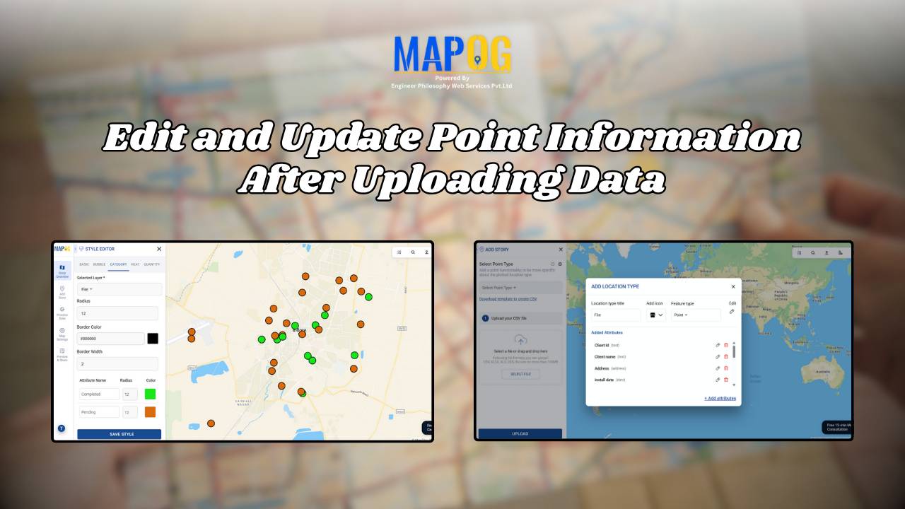
Edit and Update Map Data for Fire Safety and Infrastructure Projects

When managing urban infrastructure projects, uploading data to a map is only the beginning. The real value emerges when teams can edit and update point information after uploading data seamlessly. For example, a fire safety company that installs alarms every month needs to keep its records accurate and current. While uploading installation data offers an … Read more

Draw & Style Property Boundary Polygons on a Map

Draw & Style Property Boundary Polygons on a Map

With the help of GIS, professionals Draw and Style Property Boundary Maps to visualise, manage, and analyze land ownership clearly and efficiently. Whether you are a city planner, a surveyor, a real estate professional, or simply someone trying to understand land parcels in your community, drawing and styling property boundary mapping with GIS includes polygons … Read more

Fire Station Mapping: How GIS Fire Safety Maps Improve Emergency Response & Community Safety

Fire station mapping is an important step as fires spread fast, and when communities lack nearby fire stations, hydrants, or safety infrastructure, the risk of damage rises dramatically. That’s why mapping fire safety infrastructure has become an essential tool for city planners, emergency responders, and local authorities. furthermore using GIS-based interactive tools like MAPOG to … Read more

Interactive Retail & Lifestyle Events Map: Smarter Event Discovery with GIS

In today’s fast-paced world, events bring communities together, whether it’s a fashion exhibition, lifestyle fair, gadget expo, or festive pop-up market. But with countless events happening simultaneously, it can be difficult for organizers, retailers, and attendees to plan effectively. This is where an Interactive Retail & Lifestyle Events Map indeed becomes a game changer. Consequently … Read more

How Interior Designers Can Manage Projects On-Map, Not on Spreadsheets

Managing interior design projects often feels overwhelming, especially when updates are scattered across WhatsApp chats, shared drives, and endless spreadsheets. For years, spreadsheets seemed like the go-to option; however, they usually fail to provide clarity when teams need real-time visualisation across multiple sites. That’s exactly where interactive maps step in. With MAPOG, Interior design project … Read more

Mapping Public Amenities to Spot Underserved Areas and Plan New Developments

Public Amenities Mapping with GIS: How Cities Can Improve Schools, Hospitals, Parks & Community Services

Mapping Public Amenities to transform your city into a granted transparent, inclusive, and well-planned urban space with GIS-powered public amenity mapping. This modern approach enables governments, planners, and communities to visualize essential services such as schools, hospitals, parks, libraries, and more on a single interactive map. By identifying underserved areas as much as cities can … Read more

Interactive Map of Top Colleges and Universities for Students

Interactive Map of Top Colleges and Universities for Students: A Complete Guide to Choosing the Right Institution

Education shapes futures, and therefore knowing where the best institutions are located is essential for students, parents, and policymakers. Moreover, Interactive Map of Top Colleges and Universities for Students is not only exciting but also visually engaging. In addition, they help at the same time, to find nearby facilities such as electric vehicle stations. Furthermore, … Read more

Visualize Your Entire College on an Interactive Campus Map

Interactive Campus Map: Visualize Your Entire College with Smart Digital Navigation

Visualize Your Entire College into a smart, navigable, and interactive digital hub with GIS-powered campus mapping. This modern solution allows colleges and universities to showcase their entire infrastructure—academic buildings, hostels, sports arenas, cultural centers, and even upcoming event venues—on a single interactive map. In this case students, faculty, visitors, and alumni gain instant access to … Read more

How GIS Identifies Medical Investment Hubs for Strategic Healthcare Real Estate Growth

Investing in healthcare-focused real estate requires precise Medical Investment Hubs with GIS mapping to identify prime locations near hospitals, clinics, and medical research centers. Likewise, by plotting healthcare hubs, nearby amenities, and transport access, planners and investors can ensure informed decisions, strategic growth, and community well-being using interactive maps with healthcare and property data. Key … Read more

Using GIS to Map Nearest Blood Banks to Hospitals

How GIS Maps the Nearest Blood Banks to Hospitals for Faster Emergency Response

GIS to Map Nearest Blood Banks to Hospitals is revolutionizing emergency healthcare infrastructure. This powerful application enables medical professionals, urban planners, and public health officials to improve accessibility, cut response times, and ensure blood availability during crises. MAPOG provides real-time insights, helping decision-makers coordinate resources and strengthen healthcare networks. Why Use GIS for Mapping the … Read more