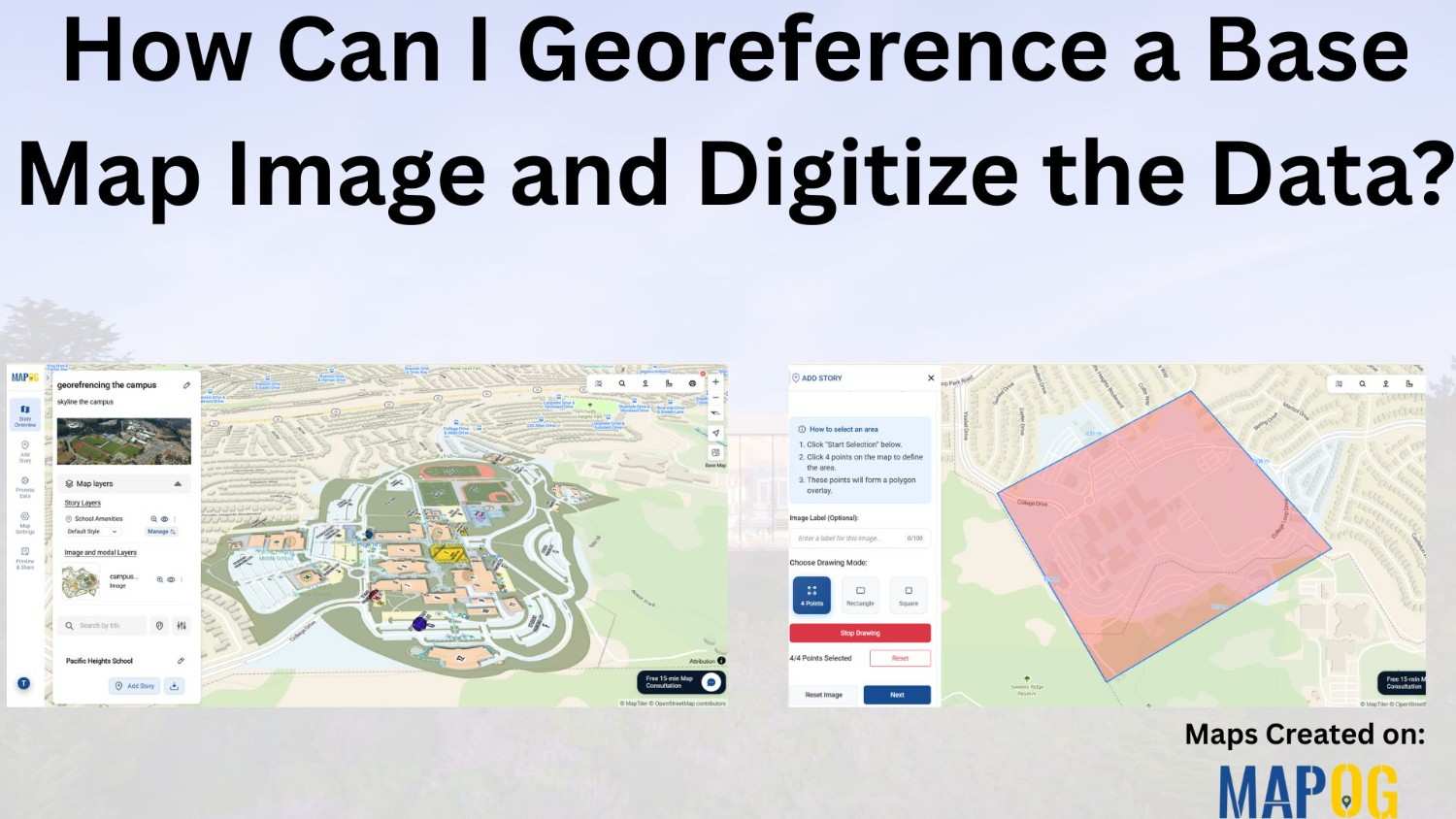
Blog

Extracting Drainage Networks for Hydrological Analysis: Step-by-Step Guide with GIS Tools

Understanding water flow patterns is crucial in hydrological analysis, and extracting drainage networks accurately is key to this endeavor. This article is all about Extracting and Creating Drainage Network Maps for Hydrological Analysis. With the additional support of MAP OG’s MAP ANALYSIS tool, users gain enhanced insights and efficient mapping solutions. Let’s explore this essential … Read more

Reef Mapping Techniques Transforming Marine Conservation and Ocean Research

Reef Mapping Techniques: Transforming Marine Conservation and Ocean Research

Reef mapping stands at the forefront of marine conservation efforts, offering critical insights into the health and distribution of underwater ecosystems. Leveraging advanced GIS technology like MAPOG, researchers are now able to visualize underwater worlds with unprecedented clarity, using variant colors to represent their extent and density. MAPOG also plays vital role in other sectors … Read more

Power Line Vulnerability Analysis: Using GIS Tools to Mitigate Vegetation Risks

In the modern world, electricity is the lifeline powering various infrastructures, industries, and households. But power lines are vulnerable to damage from various natural and anthropogenic factors, with vegetation interference being a significant concern. In this scenario, we can utilise MAPOG to conduct power line vulnerability analysis. This article explores the identification of high-risk vegetation … Read more

Mapping Pollution Around Construction Sites: A GIS-Based Approach to Environmental Management

In the pursuit of sustainable development, understanding and mitigating pollution around construction sites have become imperative. This article delves into the innovative approach of utilizing MAPOG to map pollution around construction zones levels effectively. By harnessing the power of GIS technology, this study aims to provide a comprehensive understanding of pollution dynamics in construction zones, … Read more

Road Network Categorization and Labeling for Enhanced Safety and Efficiency

Road Network Categorization and Labeling for Enhanced Safety and Efficiency

In the realm of road network categorization and labeling, accurate mapping is essential for both efficient travel planning and enhanced safety. By leveraging advanced techniques in cartography and GIS, we can create clear, usable road maps that optimize emergency responses, transportation planning, and urban development. This article delves into the methodologies of categorizing and labeling … Read more

Mapping Pedestrian Crosspoints Near Educational Institutions Enhancing Accessibility and Safety

Mapping Pedestrian Crosspoints Near Educational Institutions: Enhancing Accessibility and Safety

Accessibility to educational institutions is a fundamental aspect of ensuring equitable education opportunities for all. Pedestrian crosspoints near Educational Institutions play a crucial role in facilitating safe and convenient access to educational institutions. MAPOG is a powerful tool for evaluating and improving accessibility infrastructure. This article explores the application of MAPOG in identifying Pedestrian Crosspoints … Read more

How to Create a Map for Land Digitization and Division

In urban planning and land management, digitization of land parcels and equitable division stand as pivotal tasks. Digitization emerges as a transformative tool, promising accuracy, transparency, and accessibility in the division process. In this article, we delve into the process of digitizing land parcels and equitable division using MAPOG Map Analysis. Join us as we … Read more