Juhi

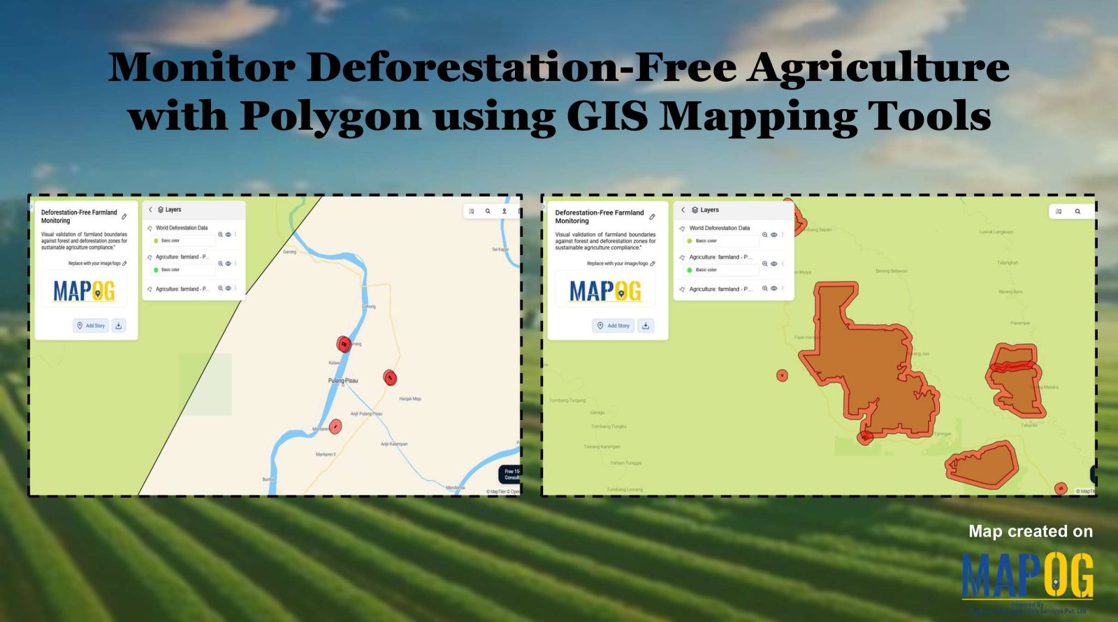
Monitor Deforestation-Free Farming Using GIS Mapping and Spatial Analysis Tools

In sustainable land management, it’s critical to monitor deforestation-free farming using spatial GIS tools that help understand how agriculture interacts with ecosystems. As deforestation becomes a pressing concern, agri-businesses and regulators require spatial evidence to ensure farming doesn’t encroach on forested areas. With MAPOG, spatial data becomes a powerful tool for environmental accountability and transparent … Read more

Create a Buffer Analysis to Locate Hospital Within 5km radius of Village

Finding healthcare gaps isn’t just about counting hospitals. Rather, it’s about understanding access, travel range, and unserved rural zones. Therefore, with the help of MAPOG, planners and health departments can visualize these relationships using buffer analysis. Additionally when used in combination with choropleth-style overlays, village point layers, or service area mapping tools, MAPOG makes it … Read more

Mapping Emergency Services Near Education Institutions Using GIS

How to Map Emergency Services Near Educational Institutions Using GIS Tools

Ensuring the emergency services Near Education become more critical than ever safety of students in educational institutions is a high priority in urban and regional planning. As cities expand rapidly and population density increases.  This article explains how Geographic Information Systems (GIS) can be effectively used to map emergency services near educational institutions. For this … Read more

Create a Real Estate Map with Filters for Price, Location, and Property Type

Mapping has become an essential tool in the real estate industry to display property data and attract potential buyers visually. One such powerful and easy-to-use tool is  MAPOG, which allows users to Create real estate Property Map with filters such as price, location, and property type. This article walks you through the methodology step-by-step, explains … Read more

Create a map Fire Stations to Industrial Areas: Mapping Using GIS Tools

In rapidly growing cities, fire safety is critical—particularly in industrial zones, where risk is high and emergency response must be quick. Moreover, fire stations in industrial areas play a key role in reducing disaster response time. This project uses MAPOG, a cloud-based spatial mapping platform, to visualize and analyze coverage gaps in fire response infrastructure. … Read more

Create Map of Sewage Lines and Water Cross-points for Urban Infra Projects

In urban planning, mapping sewage lines and water isn’t just about locating pipelines—it’s about understanding how systems connect and where they fall short  Therefore, as cities expand, planners need clear ways to visualize the relationship between sewage networks and treatment facilities. As a result, with MAPOG, spatial data becomes actionable insight. Mapping sewage and drainage … Read more

How Real Estate Agents Use Maps to Sell Properties Smarter

How Real Estate Agents Use Maps to Sell Properties Smarter

In real estate, using real estate map tools helps agents present not just the property, but its location benefits too. More agents now use interactive maps to help buyers understand not just the home, but its surroundings—like nearby parks, schools, transit, and conveniences. Embedding maps into property listings makes websites more engaging. When buyers can … Read more

Create a Travel Journal on a Map – Add Photos, Notes & Pins

Create a Travel Journal on a Map – Add Photos, Notes & Pins

Planning your next adventure? Don’t just jot down your stops—Create a Travel Journal on a Map to capture every moment. A Travel Journal Map helps you organize memories by location, add photos and notes, and visually share your journey. With MAPOG, it’s easy to plan your route, add key locations, and share it online with … Read more

Performing Retail Site Selection with Convex Hull Analysis

Performing Retail Site Selection with Convex Hull Analysis

Choosing the right retail location goes beyond guessing where people shop. Instead it’s about recognizing spatial clusters, identifying market gaps, and optimizing coverage. With this in mind, MAPOG, retailers can make data-driven decisions by interpreting customer and store distributions visually. Coupled with heat bubble styling, grid-based analysis, or retail site selection , MAPOG enables smarter … Read more

Mapping Waste Disposal Sites with GIS for Clean Cities

In fast-growing cities, mapping waste disposal sites with GIS is becoming essential to public health and sustainability. As waste volumes rise, understanding where and how it’s managed is key to building cleaner, more efficient cities. This project uses MAPOG, a cloud-based spatial mapping platform, to visualize key waste disposal sites—ranging from major landfills to Refuse … Read more