In today’s competitive digital marketplace, real estate agents are increasingly turning to interactive tools to stand out and better serve their clients. One of the most impactful tools in this space is an embedded map. By leveraging Geographic Information Systems (GIS), agents can provide rich, interactive experiences that go far beyond static listings. Through this technology, potential buyers can visualise property locations, explore nearby amenities, and understand neighbourhood dynamics all directly on your website. Whether you’re a solo agent, part of a firm, or managing a comprehensive real estate portal, embedding maps Boosts Website can significantly elevate user interaction with listings and, consequently, increase overall engagement.
Key Concept: Why Embedding Maps Boosts Website in Real Estate
In real estate, location is everything but trying to convey that importance through text alone can be limiting. This is where embedded maps truly shine, as they bridge the gap between raw data and intuitive decision-making by offering spatial context. When users view a property on a map, complete with surrounding schools, transport links, shopping centers, and parks, they gain an immediate, comprehensive understanding of its value. As a result, these visual cues create a more immersive browsing experience, encouraging users to stay longer, explore more deeply, and feel more connected. Ultimately, it’s not just about showing where a property is it’s about telling a story through location.
Educational Importance and Uses of Embedding Maps Boosts Website for Real Estate
In addition to enhancing the browsing experience, interactive GIS-based mapping supports a variety of marketing and educational objectives. These include:
- Property Location Awareness: Maps let users visualize exact locations and understand spatial relationships something text alone can’t offer. As a result, buyers make more informed, location-based decisions.
- Community Insights: Additionally, maps highlight neighborhood features, demographics, and amenities, helping users build a sense of place and belonging.
- Interactive Filtering: With ease, users can click map markers to filter properties by type, price, or features making exploration intuitive and efficient.
- Enhanced Client Experience: Through interactive tours, users enjoy a near in-person experience all from home, boosting comfort and confidence.
- Digital Competence: Finally, using GIS tools builds essential digital skills, positioning agents as tech-savvy and future-ready in today’s real estate market.
Methodology: Creating an Embedding Maps Boosts Website Using GIS
This comprehensive, step-by-step guide titled “Why Embedding Maps Can Boost User Engagement on Your Website: as a Real Estate Agent” outlines how to create an interactive, informative, and user-friendly property map using MAPOG.
1. Selecting Property Listing
- To begin, start by compiling a list of property listings you wish to showcase on your map. Ensure that each listing includes Property Name/Type, Key Features (e.g., number of bedrooms, bathrooms, total area), Realtor Contact Information.
- Additionally, consider adding a short blurb or summary for each listing to highlight what makes it unique. This not only enhances user experience but also increases emotional engagement with each property.
2. Gathering Geographic Coordinates
- Next, gather geographic coordinates (latitude and longitude) for each property. You can do this either by: Using municipal GIS data portals, Manually identifying coordinates via online maps.
- Accuracy here is crucial to ensure a seamless and trustworthy user experience. Once collected, store these coordinates in a spreadsheet along with corresponding property details. This organized format will greatly streamline the mapping process.
3. Adding Points Using MAPOG
Now it’s time to bring your interactive map to life:
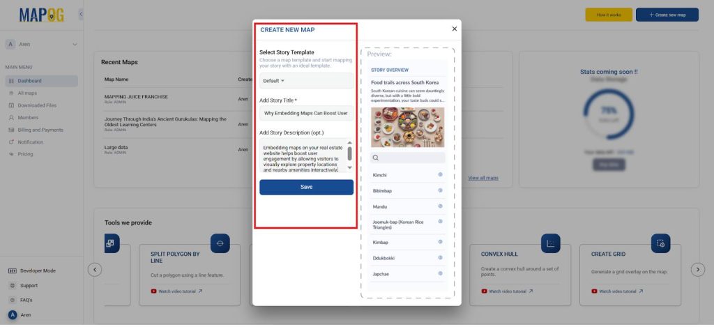
- Navigate to “Create new map” in MAPOG and choose the “Default” story type.
- Title your map appropriately (e.g., “Why Embedding Maps Can Boost User Engagement on Your Website: as a Real Estate Agent”).
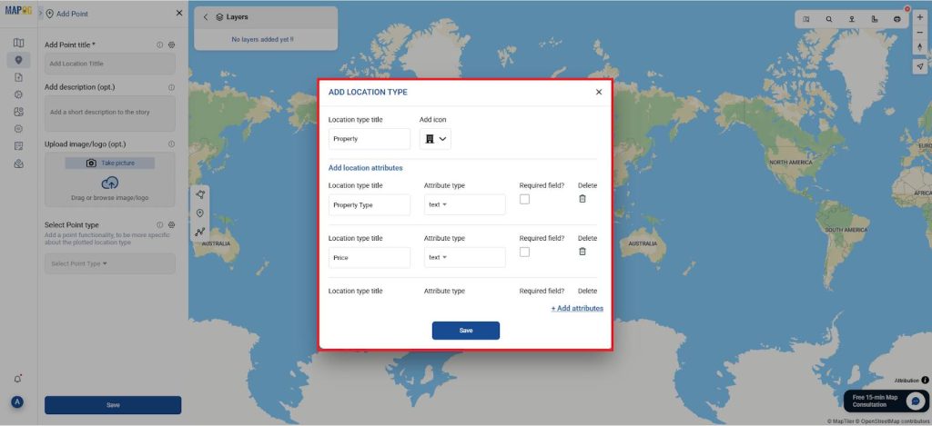
- For each property listing: Select “Add story”, then “Select Point Type” Create a new category such as “Property Listing” Add custom attributes like: Property Type, Land extent, Total Units, Blocks, Floors, Units per Floor, and Apartment Types & Sizes— all as “Text” fields.
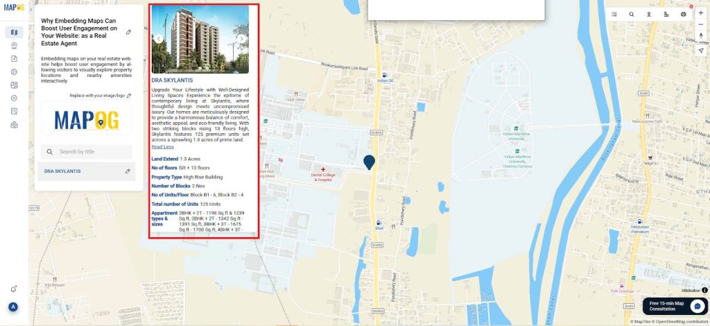
- · Then, upload a property image, provide a compelling description, and save it.
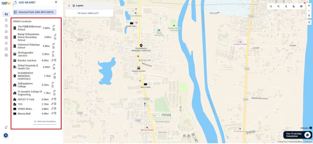
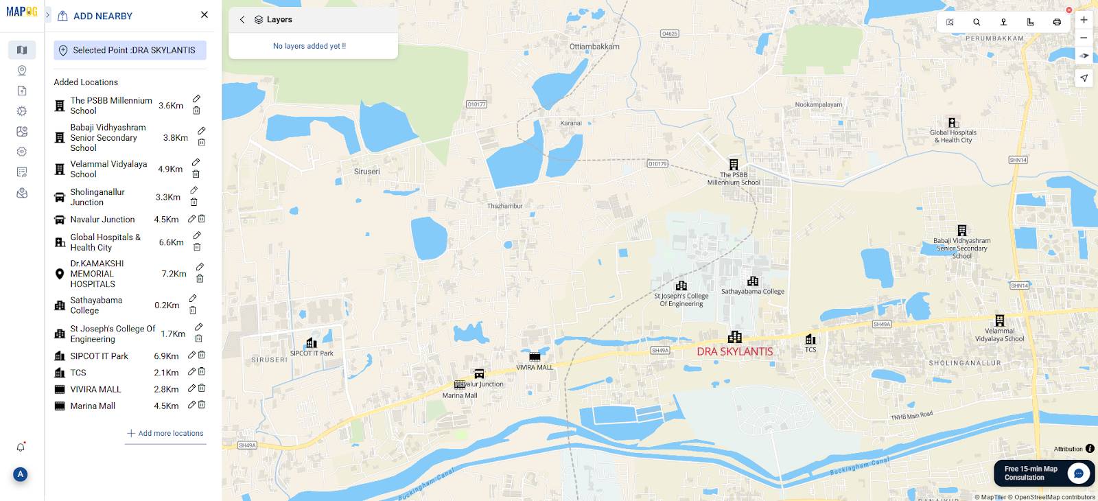
- Similarly, select “Nearby Locations” and add categories like: Schools, Transit Access, Hospitals, Colleges, IT Companies, Entertainment & Shopping.
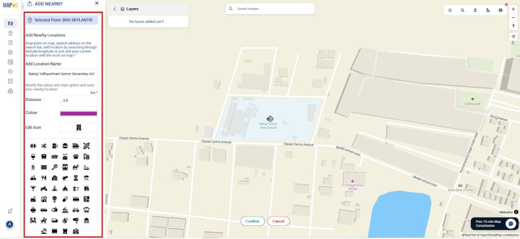
- For each nearby location, input the distance from the property, assign appropriate icons, and label them clearly. Either manually search for these locations or use the toolbox icon to enter latitude and longitude values directly.
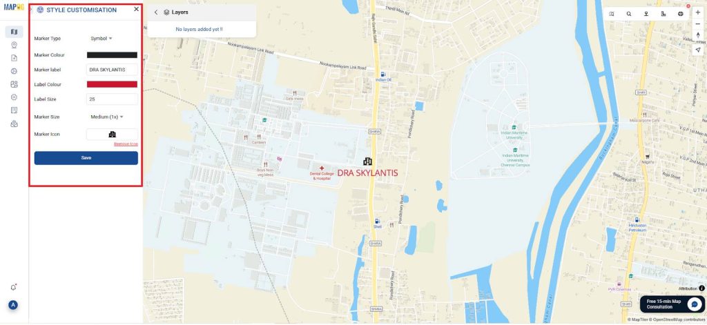
4. Styling and Visualization
To enhance the visual impact and usability of your map:
- Use distinct marker colors or icons to represent different property types (e.g., residential, commercial).
- Apply branding colors or neighborhood themes to align the map’s design with your website’s aesthetic.
- As a result, your map will not only look more professional but also provide a visually enjoyable experience that encourages users to stay longer.
5. Presentation and Sharing
Once your map is complete:
- Use MAPOG’s “Publish & Share” feature to generate an embed code.
- Insert this code into your website’s listing pages, blog posts, or even property-specific landing pages.
- Additionally, share the public link across social media platforms, email newsletters, or client campaigns.
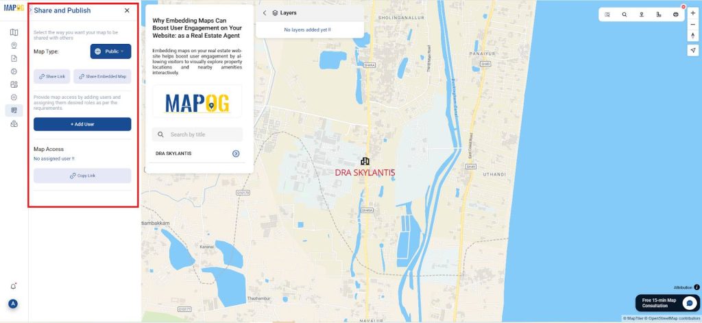
- The interactive format encourages deeper exploration, supports more confident decision-making, and improves SEO by increasing time-on-page and reducing bounce rates.
Principal Results of Embedding Maps Boosts Website
The final product is an interactive, visually rich, and data-driven map that fundamentally transforms how property listings are experienced online. Unlike static pages, these maps actively invite exploration, encourage comparison, and significantly simplify location-based decision-making. Through intuitive features, users can explore properties by location, discover nearby amenities, and gain a virtual “neighborhood tour”—all without ever leaving your site.
In turn, this added layer of context builds trust, enhances the buyer’s journey, and positions you as a forward-thinking, client-focused real estate professional. Ultimately, such innovation leads to higher conversion rates, improved client satisfaction, and increased referral potential.
Industry and Domain
Industry: This approach operates at the intersection of Real Estate Technology (PropTech), Web Design, and Location-Based Services. In doing so, it demonstrates how modern GIS tools can be used strategically to improve client interaction and decision-making. By bridging these disciplines, it highlights a more immersive and data-rich way to present properties online.
Domain: Applicable domains include Real Estate Marketing, Urban Planning, Digital Mapping, and Client Experience. Whether you’re a real estate agent, broker, or digital marketer, you stand to gain significantly by embracing this tech-forward methodology. Moreover, by adopting this approach, professionals can not only enhance engagement but also drive smarter, more confident client decisions.
Conclusion
Embedding GIS-based maps is not just a tech upgrade—rather, it represents a revolution in client engagement. By seamlessly transforming the way properties are showcased online, these maps ultimately provide richer experiences, deeper insights, and more confident, informed decisions. As a result, buyers are able to fall in love not only with a home but also with its surroundings.
Moreover, for real estate agents, it’s a game-changing way to truly stand out, consistently build trust, and more effectively close deals in today’s highly competitive landscape. So, are you ready to level up your listings? Now is the time to start building your interactive property map with MAPOG—and in doing so, turn browsers into buyers one clicks at a time.
MAPOG was utilized across multiple studies referenced in this context.
- Role of GIS In Irrigation Planning and Water Resource Management
- How GIS and Smart Mapping Reduce Urban Heat Islands
- GIS in Infrastructure Development and Road Network Analysis
- Flood Risk Mapping with Interactive Web Maps: SaaS Approach
- Optimizing Warehouse Location Selection with GIS for Supply Chain Efficiency