MapogAkshay

GIS Tool for Organic Farming

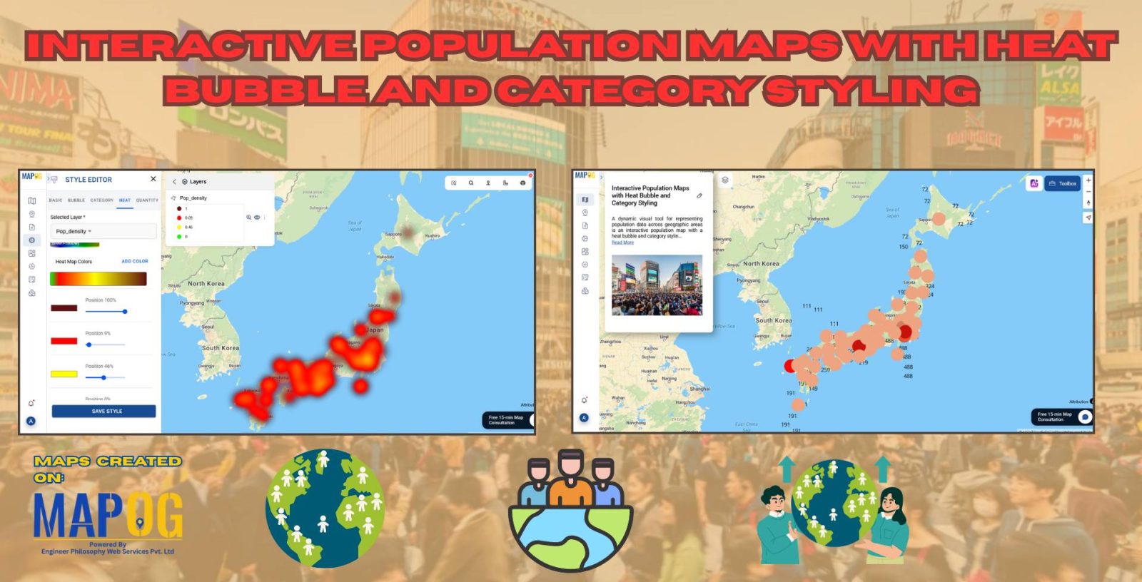
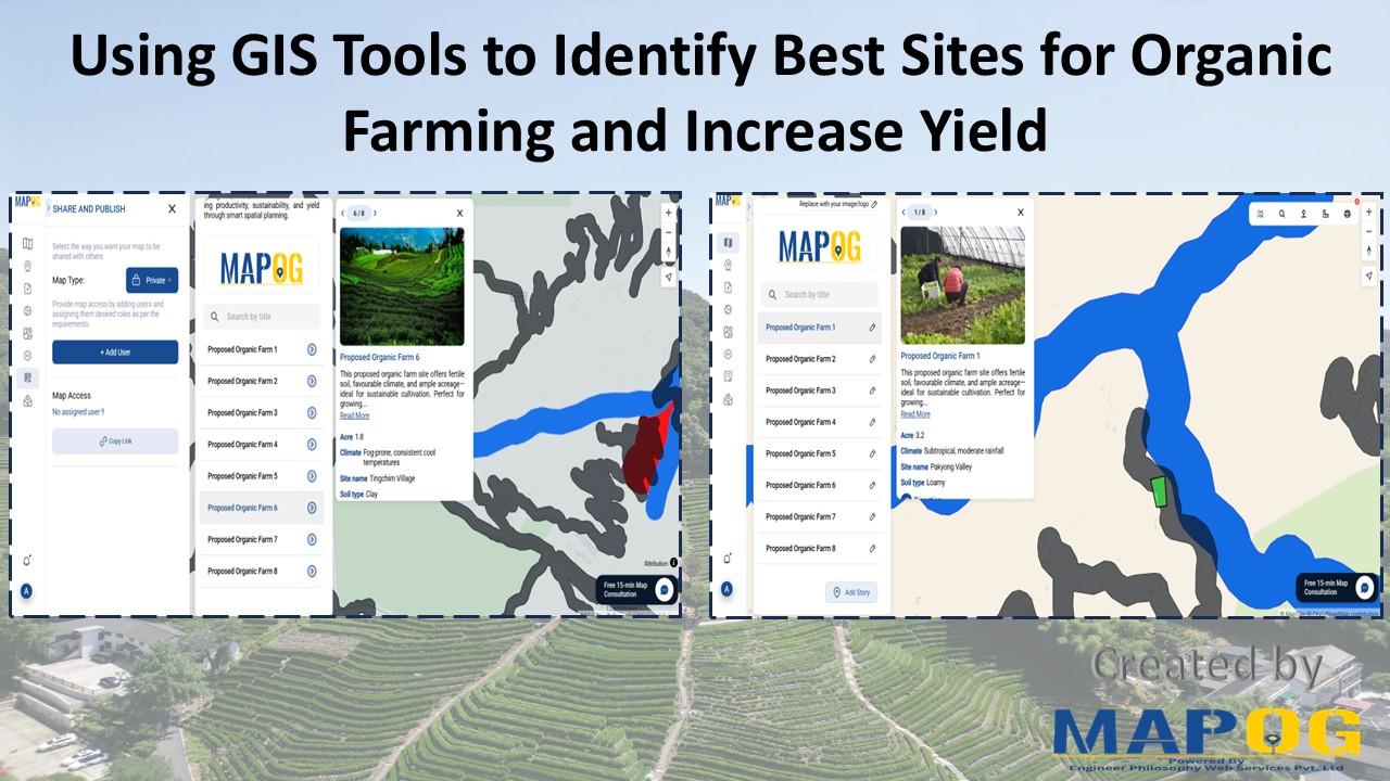
Using GIS Tools to Identify Best Sites for Organic Farming and Increase Yield

With the rise of sustainable agriculture, organic farming meanwhile emerges as a key method for eco-friendly food production. However, its long-term success depends, above all, on precise site selection. Fortunately, with the help of a GIS Tool for Organic Farming, such as MAPOG, users can seamlessly adopt Smart Farming with GIS. Moreover, by seamlessly layering … Read more

Interactive Population Maps

Interactive Population Map with Heat Bubble and Category Styling

Analysing and interpreting population data across various geographic regions can be done visually with Interactive Population Maps with Heat Bubble and Category Styling. It is simple to quickly identify high and low concentration areas on these maps because they use heat bubbles, which vary in size and colour, to represent population density or totals. Furthermore, … Read more

Interactive Property Hunt Map

How to Organise Your Property Hunt: Pin Live Locations, Add Photos, and Manage All Details on One Interactive Map

Searching for a new home can be both exciting and overwhelming. With endless property listings, scattered notes, and various amenities to consider, it’s easy to feel lost in the process. That’s where an Interactive Property Hunt Map becomes a game-changer. By using smart tools like MAPOG, you can visually organize your entire home search—pinning property … Read more

“A digital map highlighting water-scarce villages and nearby water sources in India using GIS tools, illustrating buffer zones, village boundaries, and water infrastructure.”

GIS-Based Mapping of Water-Scarce Villages and Nearest Water Sources

Water scarcity continues to challenge many rural areas across India. With shifting climate patterns, population pressures, and the overuse of natural resources, numerous villages face both seasonal and long-term water stress. However, Mapping Groundwater Concentration through GIS presents a powerful approach to this issue. By visualizing the availability and distribution of subsurface water, it becomes … Read more

“Visual map showcasing top universities categorized by popular courses such as MBA, Law, Engineering, and more”

Top Universities on Map by Popular Courses: MBA, Law, Engineering & More

In a globally connected world, students, researchers, and academic planners are increasingly turning to smart solutions for understanding how leading institutions are distributed across regions. Whether you’re exploring top engineering schools, renowned MBA programs, or historic fine arts colleges, mapping education institute places offers a dynamic and visual way to grasp academic reach and reputation. … Read more

How to Upload and Visualize CSV Data on a Map

How to Upload and Visualize CSV Data on a Map

In today’s digital world, knowing how to upload and visualize CSV data on a map is essential for urban planning, environmental monitoring, and compelling visual storytelling. Moreover, with the growing importance of data-driven storytelling and location-based insights, MAPOG provides an intuitive platform to transform your spreadsheet data into interactive maps. As a result, users can … Read more

"Safari Itinerary MAP"

Safari Itinerary on Map: Explore Wildlife Destinations Visually

Planning a wildlife safari involves more than just booking a jeep and packing a camera. In fact, to make the most of your adventure—especially in biodiversity-rich parks like Kaziranga—it’s essential to prepare a detailed safari itinerary on map. By doing so, you can visualize routes, mark important safari zones, and stay organized throughout the journey. … Read more

Travel Route Planning Made Simple with Story Maps

Travel Route Planning Made Simple with Story Maps, Story maps are a creative way to integrate storytelling and geographic data, enabling users to see events, experiences, and manage plans on an interactive map combine narrative text, multimedia, and maps to produce a dynamic, captivating format that improves comprehension and sharing. Users can view events, experiences, … Read more

How GIS Helps in Hospital Site Selection and Healthcare Accessibility Analysis

How GIS Helps in Hospital Site Selection and Healthcare Accessibility Analysis

 In our fast-evolving cities and growing rural communities, access to healthcare is a basic need which still remains unevenly distributed. The healthcare revolution arises from Geographic information Systems (GIS) which enables complex data to be converted into life-saving decisions such as hospital site selection and healthcare  Through integration of several layers, GIS produces an accurate … Read more