EpNisha

Best Alternatives to Google My Maps for Sharing Travel Stories

Best Alternatives to Google My Maps for Sharing Travel Stories

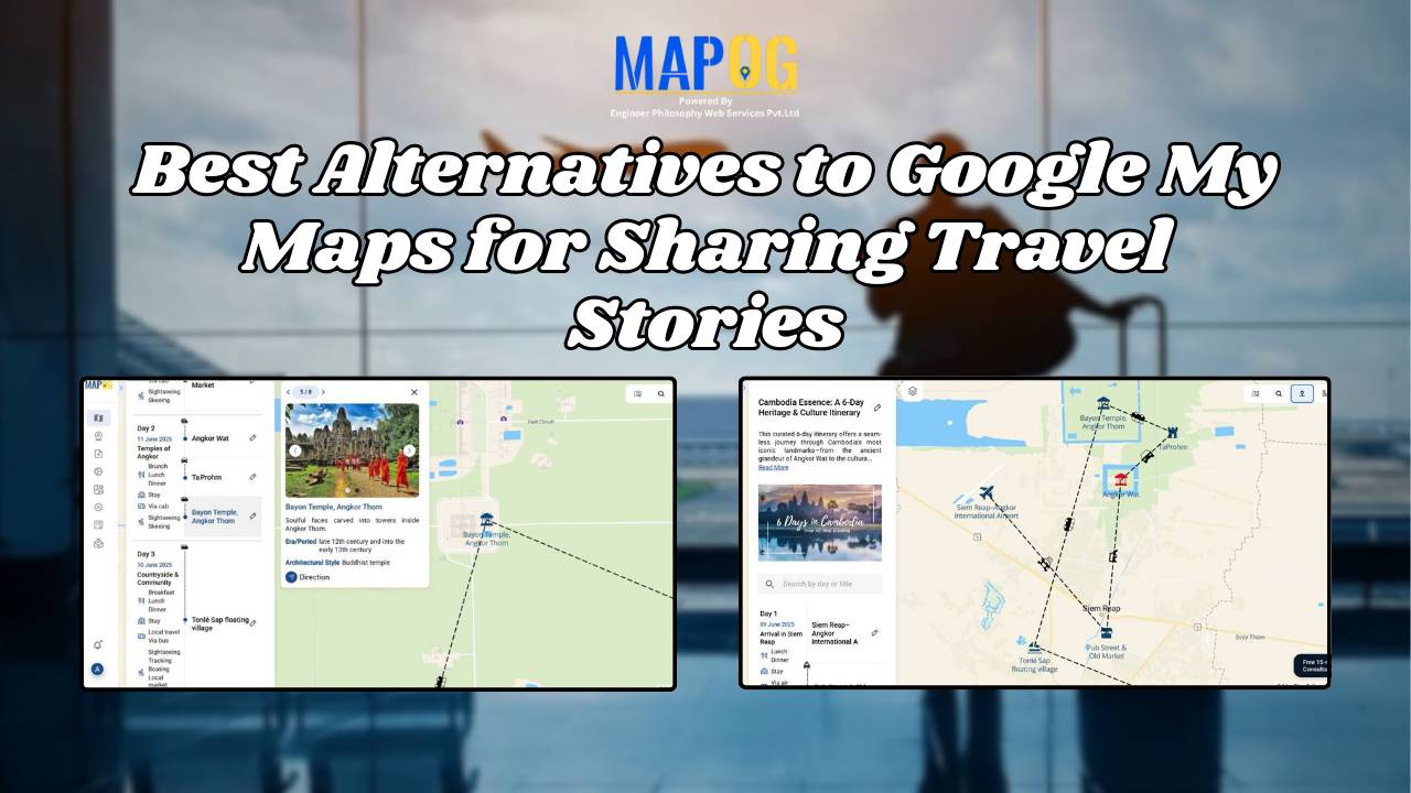
If you’re on the lookout for the best alternatives to Google My Maps, you’re not alone. Travelers, bloggers, and content creators are increasingly seeking more flexible, interactive, and storytelling-driven platforms to share their travel memories. While Google My Maps offers basic map-making features, it often falls short in terms of personalization, multi-user collaboration, and storytelling … Read more

GIS in Identifying High-Growth Areas for Real Estate Investment

GIS in Identifying High-Growth Areas for Real Estate Investment

In today’s fast-evolving urban landscape, identifying the right location for real estate investment is both a science and a strategy. GIS helps in Identifying High-Growth Areas is a go-to approach for investors and planners aiming to make informed, data-backed decisions. From analyzing transportation access to mapping nearby amenities, GIS adds a new level of depth … Read more

Mapping Crime Hotspots

Mapping Crime Hotspots Using Grids and Heat Bubble Tools

Mapping crime hotspots is a critical approach in understanding and preventing urban crime. By visualizing clusters of criminal activity, law enforcement and urban planners can make informed, data-driven decisions. One modern way to do this effectively is through interactive mapping platforms that offer grid-based analysis and visual heat bubble styles—such as MAPOG’s intuitive tools. This … Read more

How to Create a Travel Itinerary on a Map and Share It Online

How to Create a Travel Itinerary on a Map and Share It Online

If you’re planning your next big adventure, there’s one thing you shouldn’t skip—how to create a travel itinerary on a map and share it online. It not only helps you stay organized but also allows your friends or travel buddies to follow along in real-time. With intuitive platforms like MAPOG, it’s now easier than ever … Read more

Population Density Map by Districts

How To Create Population Density Map by Districts

Visualizing population density map by districts helps uncover patterns in urban growth, resource distribution, and planning needs. Whether you’re working on development plans, healthcare access, or disaster preparedness, mapping this data by district brings clarity that raw tables cannot. Thanks to MAPOG, users can create, style, and share interactive maps easily—no advanced GIS degree needed. … Read more

mapping sewage and drainage systems

Mapping Sewage and Drainage Systems Using Cross Intersection Tool

Nowadays, mapping sewage and drainage systems has become a smarter and more data-driven approach to urban planning and environmental safety. In particular, mapping such infrastructures helps identify pollution risks, optimise maintenance, and prevent disasters. One powerful way to achieve this is through the use of spatial tools like buffer zones and cross-intersection methods. By doing … Read more

GIS helps in solar energy site suitability and analysis

How GIS helps in Solar Energy Site Suitability and Analysis

In today’s renewable energy movement, GIS helps in solar energy site suitability and analysis by providing precision, clarity, and data-driven decisions. This blog unpacks how Geographic Information Systems are transforming how we identify optimal solar farm locations, ensuring both efficiency and environmental harmony. Through a practical example using real GIS tools, you’ll discover how layered … Read more

GIS in land use and zoning analysis for better city planning

GIS in Land use and Zoning analysis for better city planning

In today’s fast-changing urban landscape, GIS in land use and zoning analysis for better city planning plays a vital role in shaping smarter, more livable cities. Whether it’s managing population growth, conserving green spaces, or optimizing infrastructure, city planners increasingly depend on GIS to make informed decisions. This article explores how GIS tools enhance zoning … Read more

How to use GIS for Soil Mapping and Crop Monitoring

GIS is crucial in agriculture for soil mapping and crop monitoring, enabling informed decisions to improve yield, optimize land use, and ensure sustainable farming. It helps identify soil types, track crop density, and enhance precision farming by processing and visualizing soil and crop data. Key Concepts in GIS for Soil Mapping and Crop Monitoring GIS … Read more