In the realm of modern travel, airports not just serve as gateways to destinations but also operate as hubs for retail exploration. Nevertheless, maneuvering through shopping adventures in close proximity to airports can prove overwhelming. This is precisely where MAPOG steps in—a GIS platform that revolutionizes the exploration of premium shopping experiences near airports. This article delves into MAPOG‘s isochrone maps: they offer a quick snapshot of nearby shops reachable within a specific time frame from the airport. And a Isochrone Time-efficient Shopping.
MAPOG also plays vital role in other sectors like transportation. You can go through this article ‘GIS Analysis in Urban Planning: Reshaping Transportation Future Insights of state/city‘ to know more about. You can go through the article- Creating Buffer Maps to Improve the Security of Airport and Other Infrastructures also.
Key Concepts for Discovering Shopping Adventures Near Airports
Furthermore, within MAPOG, the isochrone tool revolutionizes the discovery of nearby prime shopping opportunities by visually representing areas reachable from a given location within a specified travel time. Additionally, the article contains links to the GIS data we utilize at its end.
Instead of map analysis interface, Route compass is another interface of MAPOG. Check this article- ‘Make Routes for Military Aerial Planning- Through Bearing angle and Distance calculation – Online Route Compass‘ for more details.

Explore this article-Plotting Airports on MAP: Simplifying Logistics and Planning for another application of MAPOG in Airport Mapping.
Steps for Discovering Shopping Adventures Near Airports
Step 1 MAPOG Map analysis interface
To navigate to the MAPOG Map analysis interface, simply use the navigation tools and proceed directly to the interface.
Step-2 Upload Data
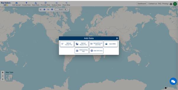
Click on the “Add Upload” option from the menu bar situated at the upper left end, then proceed to the “Add GIS Data” option to include the necessary data.
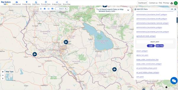
Utilizing the AI search option or manually selecting, choose the area of study. Next, scroll down to locate the airport point data, and then add it to the platform by clicking on the Add button.
Step- 3 Renaming Files
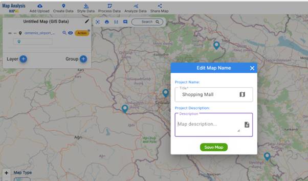
After successfully adding GIS data, the subsequent step involves naming the untitled project and providing a description of the project in the description box.
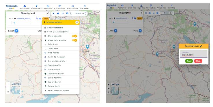
Additionally, rename the layer of GIS data added for better understanding. To do so, click on the Action button and change the layer name.
Step- 4 Thematic Styling
For better visual representation, enhance your data by utilizing the Style Data option. Choose the style you prefer. Here, opt for the basic style. Select the layer to which you want to apply the style.
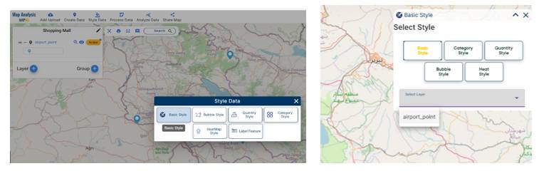
Choose an icon for the airport point, then save the style.
Step-5 Creating Isochrone for Discovering Shopping Adventures Near Airports
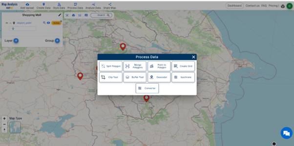
Navigate to the menu bar, then select the “Process Data” option, and click on the Isochrone tool.
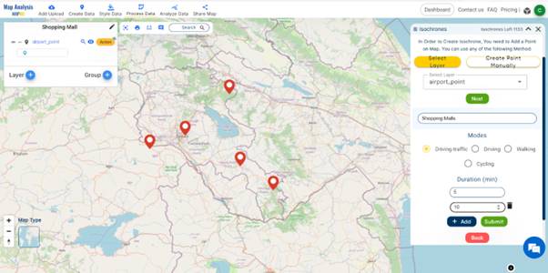
The box presented two options: selecting layers or creating points manually. Since we’ve already added a layer, choose the airport point layer to generate an isochrone. Next, input the layer name in the “Add Layer Name (shopping mall)” option. Determine the duration for displaying the isochrone. Here, durations of 5 minutes and 10 minutes are available. Additional durations can be included by clicking the “Add” button. Finally, click “Submit” to proceed.
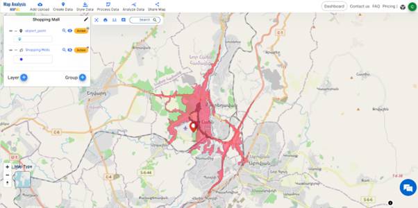
We successfully added the isochrone layer. Furthermore, to enhance representation, we can modify the style according to the attributes. To achieve this goal, opt for the category style within the Select Style option. Subsequently, conduct category styling based on duration. Choose colors for the two provided durations and then save the style.
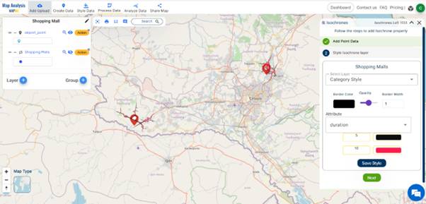
The isochrone layer was added successfully. Subsequently, zoom in to the airport points. This allows us to visualize the created isochrone.
Step -6 Share the shopping adventure map
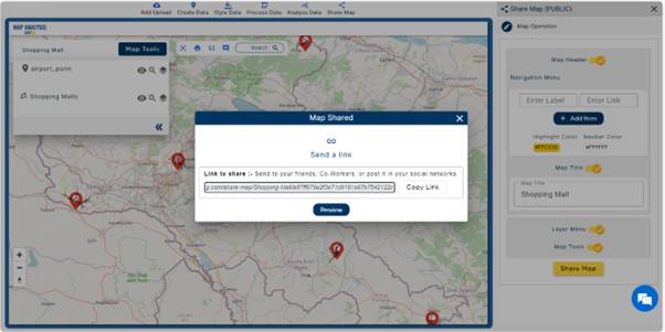
Share this map to the public to create impact using the Share Data option in the Menu bar.
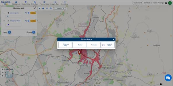
Additionally, you can also preview the map before sharing it, and afterwards, send or copy the link for sharing.
Major Findings- Discovering Shopping Adventures Near Airports
Constructing shopping malls in the isochrone areas near airports will improve
- tourism and economic stability of that area
- diverse shopping experiences
- boost to local Economy
- real estate appreciation
Domain and Industry
Our shopping adventure focuses on the tourism and real estate sectors, guided by MAPOG. This innovative approach combines Geographic Information Systems (GIS) with spatial analysis, aiming to enhance both tourism and the economy.
Conclusion
By utilizing MAPOG for site selection, it ensures that shopping adventures are positioned optimally to serve both travelers and the surrounding community, thereby fostering economic development and enhancing overall urban infrastructure.
Let’s explore MAPOG through these articles-‘Mapping Healthcare Efficiency: GIS Buffer Analysis of Hospital Locations‘ & Strategic Logistics Mapping: Optimizing E-commerce Delivery with Isochrone Analysis
Links of Data
Airport Point Data- https://mapanalysis.mapog.com/map-analysis/add-gis/airport_point
Here are some other blogs you might be interested in
- GIS Analysis in Urban Planning: Reshaping Transportation Future Insights of state/city
- Creating Buffer Maps to Improve the Security of Airport and Other Infrastructures
- Plotting Airports on MAP: Simplifying Logistics and Planning
- Strategic Logistics Mapping: Optimizing E-commerce Delivery with Isochrone Analysis