Juhi

Creating Point Data for Urban Planning: Digitizing Settlement Features & Infrastructure Mapping

Creating Point Data for Urban Planning: Digitizing Settlement Features & Infrastructure Mapping

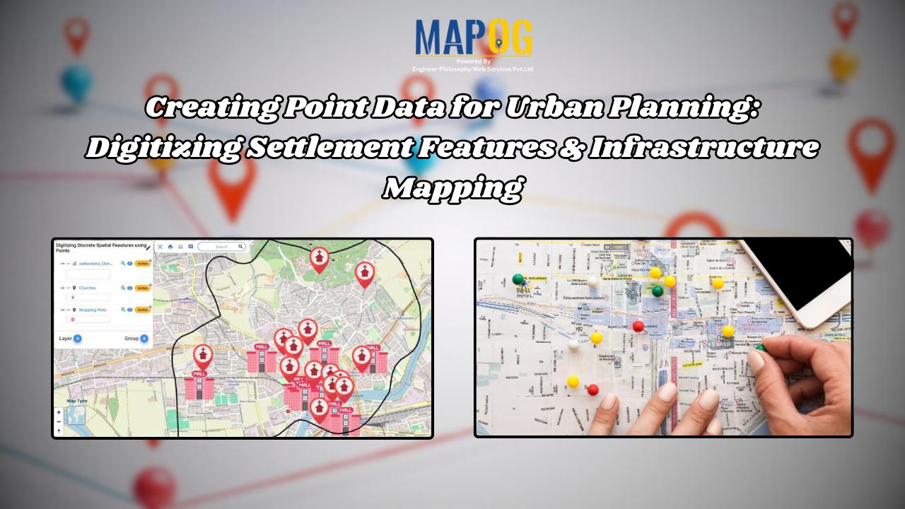
In the vast landscape of Geographic Information Systems (GIS), the meticulous process of mapping settlement features stands as a cornerstone of urban planning, environmental assessment, and resource management. Settlement features, ranging from individual households to sprawling cityscapes, serve as critical focal points in understanding human habitation patterns and societal dynamics. With the help of MAPOG … Read more

Forest Boundary Analysis: Precision Polygon Splitting for Sustainable Planning

Unveil the power of precision in GIS with MAPOG’s Split Polygon by Line tool. Explore how this innovative feature revolutionizes polygon splitting, facilitating nuanced analysis and insightful mapping with ease and accuracy. KEY CONCEPTS Our goal is to split the Polygons using the split-by-line tool from MAPOG Map Analysis. Learn more about the analyses using … Read more

Land Parcel Mapping with GIS: Create Accurate Polygon Maps for Urban Planning & Real Estate

In Geographic Information Systems (GIS), a polygon is a fundamental geometric shape used to represent closed areas on maps. Polygons in GIS are comprised of connected straight-line segments, delineating the boundaries of geographic features, including land parcels, lakes, and administrative regions. These two-dimensional shapes facilitate spatial analysis, mapping, and visualization of geographical data, playing a … Read more

How to Choose the Perfect Retail Shop Location Using Isochrone Maps – Boost Foot Traffic & Sales

Choosing the perfect spot for your retail shop can make all the difference.  With MAPOG Map Analysis, you can use the Isochrone tool to identify areas with the best customer accessibility.  Isochrone maps help you visualize travel times, ensuring you find locations that maximize foot traffic and sales potential. Explore smarter site selection with MAPOG’s … Read more

Extracting Drainage Networks for Hydrological Analysis: Step-by-Step Guide with GIS Tools

Understanding water flow patterns is crucial in hydrological analysis, and extracting drainage networks accurately is key to this endeavor. This article is all about Extracting and Creating Drainage Network Maps for Hydrological Analysis. With the additional support of MAP OG’s MAP ANALYSIS tool, users gain enhanced insights and efficient mapping solutions. Let’s explore this essential … Read more

Road Network Categorization and Labeling for Enhanced Safety and Efficiency

Road Network Categorization and Labeling for Enhanced Safety and Efficiency

In the realm of road network categorization and labeling, accurate mapping is essential for both efficient travel planning and enhanced safety. By leveraging advanced techniques in cartography and GIS, we can create clear, usable road maps that optimize emergency responses, transportation planning, and urban development. This article delves into the methodologies of categorizing and labeling … Read more