MapogAkshay

Reef Mapping Techniques Transforming Marine Conservation and Ocean Research

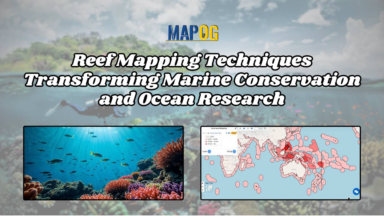
Reef Mapping Techniques: Transforming Marine Conservation and Ocean Research

Reef mapping stands at the forefront of marine conservation efforts, offering critical insights into the health and distribution of underwater ecosystems. Leveraging advanced GIS technology like MAPOG, researchers are now able to visualize underwater worlds with unprecedented clarity, using variant colors to represent their extent and density. MAPOG also plays vital role in other sectors … Read more

Power Line Vulnerability Analysis: Using GIS Tools to Mitigate Vegetation Risks

In the modern world, electricity is the lifeline powering various infrastructures, industries, and households. But power lines are vulnerable to damage from various natural and anthropogenic factors, with vegetation interference being a significant concern. In this scenario, we can utilise MAPOG to conduct power line vulnerability analysis. This article explores the identification of high-risk vegetation … Read more

Mapping Pollution Around Construction Sites: A GIS-Based Approach to Environmental Management

In the pursuit of sustainable development, understanding and mitigating pollution around construction sites have become imperative. This article delves into the innovative approach of utilizing MAPOG to map pollution around construction zones levels effectively. By harnessing the power of GIS technology, this study aims to provide a comprehensive understanding of pollution dynamics in construction zones, … Read more

Mapping Pedestrian Crosspoints Near Educational Institutions Enhancing Accessibility and Safety

Mapping Pedestrian Crosspoints Near Educational Institutions: Enhancing Accessibility and Safety

Accessibility to educational institutions is a fundamental aspect of ensuring equitable education opportunities for all. Pedestrian crosspoints near Educational Institutions play a crucial role in facilitating safe and convenient access to educational institutions. MAPOG is a powerful tool for evaluating and improving accessibility infrastructure. This article explores the application of MAPOG in identifying Pedestrian Crosspoints … Read more

How to Create a Map for Land Digitization and Division

In urban planning and land management, digitization of land parcels and equitable division stand as pivotal tasks. Digitization emerges as a transformative tool, promising accuracy, transparency, and accessibility in the division process. In this article, we delve into the process of digitizing land parcels and equitable division using MAPOG Map Analysis. Join us as we … Read more

Create Map for Coastal Erosion Assessment High-Risk Zones and Mitigation Strategies

Create Map for Coastal Erosion Assessment: High-Risk Zones and Mitigation Strategies

Coastal erosion poses a significant threat to coastal regions, jeopardizing not only the natural beauty of beaches but also the structural integrity of sea walls essential for coastal protection. In response to this challenge, MAPOG undertakes a comprehensive mapping initiative for coastal erosion assessment and mitigation. This article explores how MAPOG delineates erosion-prone areas along … Read more

GIS Tools for Creating Maps Grid Sampling in Mineral Exploration

GIS Tools for Creating Maps: Grid Sampling in Mineral Exploration

Natural resources are the cornerstone of a nation’s wealth and prosperity, but their exploration is a complex process. One crucial aspect of successful exploration is the systematic collection of geological and geochemical data across target areas. Grid sampling is one of such sampling processes. This article explores how MAPOG can be leveraged for mapping strategies … Read more

Create a Map for Visualising Earthquake Data Without Constraints

In the dynamic realm of disaster response, precision and adaptability are crucial. The MAPOG Map Analysis tool emerges as a groundbreaking solution that transcends traditional limitations in mapping seismic events. This comprehensive guide spotlights MAPOG’s unique feature: the ability to create a map for visualizing Earthquake Data without constraints. Unlike conventional tools, MAPOG empowers users … Read more