Juhi

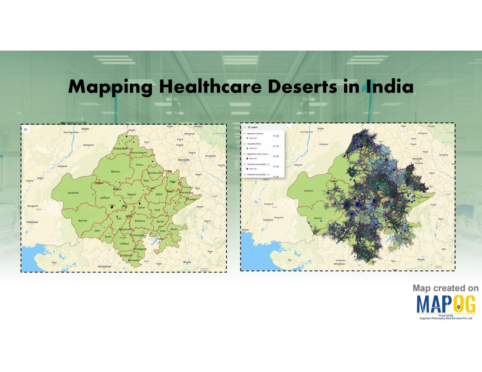
Mapping Healthcare Deserts in India

Identifying Areas with Limited Access to Doctors and Medical Facilities Mapping healthcare deserts in India helps expose one of the biggest barriers to healthcare access: geography. Although access to healthcare is a fundamental right, how soon someone can reach a hospital often depends more on location than need. Healthcare desert mapping—regions where timely access to … Read more

How GIS is Improving Traffic Management and Road Safety  

Traffic congestion and road accidents are major challenges in urban areas, leading to economic losses, increased pollution, and safety risks. As a result, Geographic Information Systems (GIS) have emerged as a powerful tool for analyzing, visualizing, and optimizing traffic flow while enhancing road safety. As a result of integrating spatial data, traffic authorities can identify … Read more

Incredible India Itinerary: A Cultural Circuit on the Map

Incredible India Itinerary: A Cultural Circuit on the Map

India is a land of diverse cultures, rich heritage, and vibrant traditions. When you think of exploring the true essence of India, it’s not just about ticking off touristy landmarks; it’s about diving deep into the heart of its culture. In this guide, we’ll show you how to create an cultural circuit on map, connecting … Read more

Offbeat Travel in India Create Personalized Maps of Hidden Gems with MAPOG

Offbeat Travel in India: Create Personalized Maps of Hidden Gems

Nowadays, when traveling is about more than just checking places off a list, offbeat destinations in India offer a deeper and more meaningful experience for the curious traveler. With its vast cultural heritage and varied topography, India is home to countless hidden gems untouched by mass tourism. So, discovering these offbeat destinations in India isn’t … Read more

wildlife monitoring and prevention using gis tool

How to use GIS for Wildlife monitoring and prevention

As biodiversity faces unprecedented loss, conservationists are using advanced mapping technology to fight back. Geographic Information Systems (GIS) have evolved into powerful tools for wildlife monitoring and protection, enabling teams to plan migration corridors, predict poaching hotspots. This technology is empowering rangers and researchers to make faster, smarter decisions, helping reverse biodiversity loss. Key Concept … Read more

Mapping Top University Nations A Quantitative Approach

Mapping Top University Nations: A Quantitative Approach

Welcome to our exploration of the world’s top university nations through a quantitative lens. Using MAPOG map analysis, we delve into the geographical distribution of universities globally.  Join us as we uncover insights that inform education policies and international partnerships. KEY CONCEPTS Our goal is to create a world map of countries with the highest … Read more

Create a Tourist Itinerary Map for the Ultimate Travel Experience

Create a Tourist Itinerary Map for the Ultimate Travel Experience

Planning a trip can be one of the most exciting yet overwhelming tasks. With multiple locations to visit, and routes to plan, having everything in one place can make all the difference. That’s where a tourist itinerary map comes in handy! Instead of juggling multiple travel apps and notes, you can organize your entire trip … Read more

How to use GIS for Mapping Disease Affected Area

 Geographic Information System is an emerging field that combines spatial analysis, statistical modeling and data visualization. We can create maps by pinpointing the location of disease outbreak by using a “point to polygon tool” and help us lineate the affected area smoothly and effortlessly. Key concept  Analysis of disease affected areas by using point to … Read more