Mapping Military Flight Paths is a crucial component in modern aerial defense planning. With the continuous rise of geographic intelligence, GIS technology now plays a central role in not only plotting accurate coordinates but also in calculating distances and determining precise bearing angles. This process, therefore, goes far beyond simply drawing lines on a map—it is, in fact, about optimizing both precision and safety in military aviation.
Key Concept: Mapping Military Flight Paths with GIS
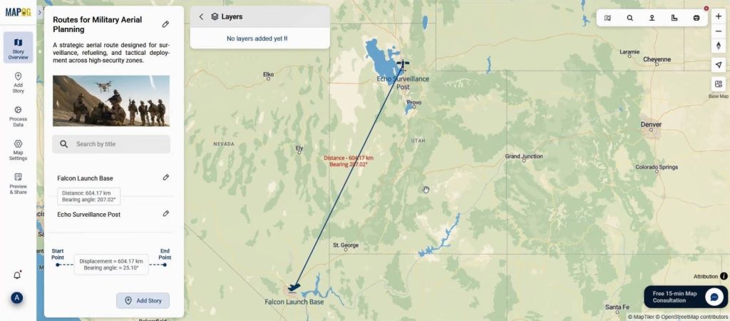
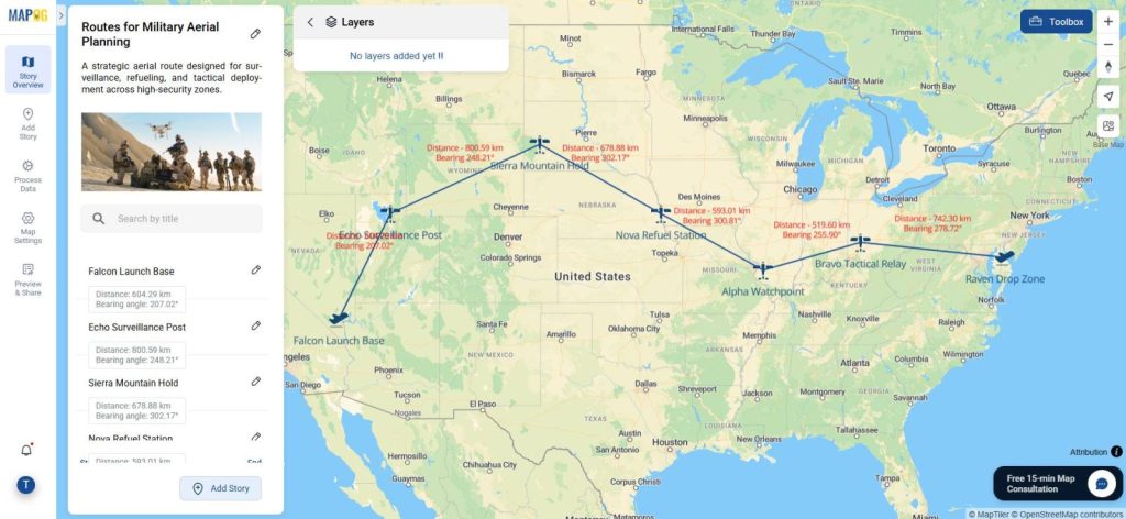
When you engage in Mapping Military Flight Paths, you’re essentially building a visual, data-rich representation of air routes between bases or critical checkpoints. In this context, GIS proves indispensable. It not only calculates the exact distance between locations but also determines the correct distance and bearing angle, thereby significantly reducing human error and, at the same time, improving mission planning. Moreover, whether you’re involved in simulation exercises, planning strategies, or even sharing vital flight route data with stakeholders, using a GIS platform like MAPOG adds both accuracy and structure to the process.
Step-by-Step Guide to Map Military Flight Paths with GIS
1. Start a New Map on MAPOG
To begin, first head over to MAPOG. Once you’re on the platform, click on “Create new map”. Then, set the map mode specifically to the bearing angle format. After that, add a compelling title and a clear description—you may also optionally upload an image to better illustrate the theme. Once completed, don’t forget to save your setup.

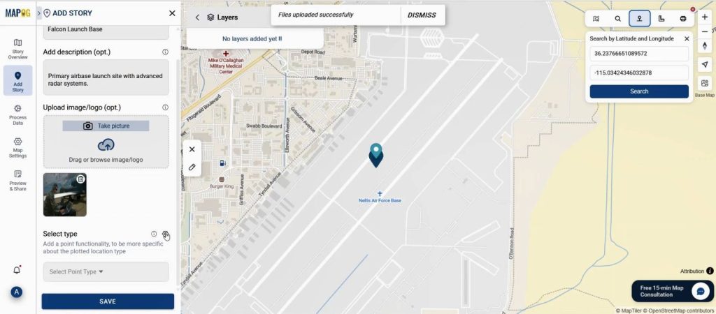
2. Add Airbase Location Using Coordinates
Next, move on to the “Add Story” option. Here, select “Add Manually” and proceed by choosing Point. In the toolbox that appears, utilize the “Search by Coordinates” function. Enter your airbase coordinates accurately, confirm the location, and then add a title, image, and a concise description to make each point informative.
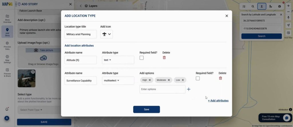
3. Define the Mission Type & Attributes
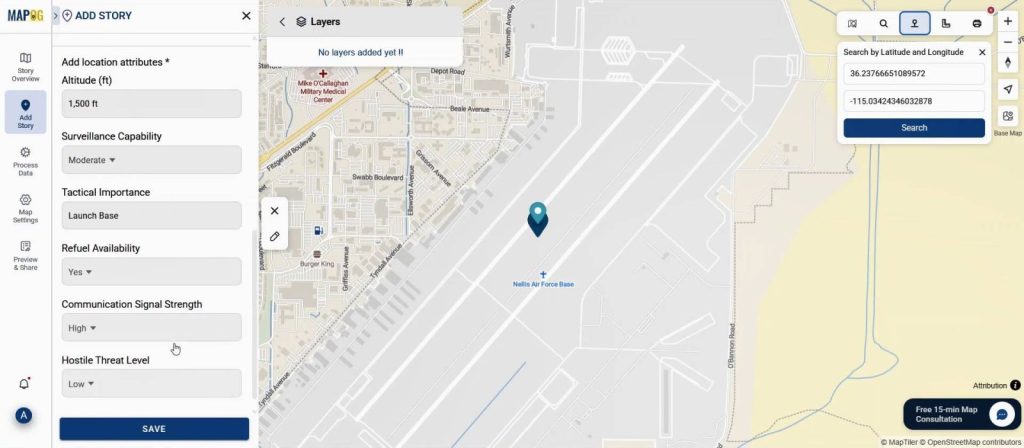
Afterward, navigate to the “Select Type” settings option, and there, click on Add New Attribute Type. Name this new category as Military Aerial Planning. Subsequently, input key attributes such as Altitude, Radar Range, Aircraft Type, and Clearance Code. Once entered, make sure to save your attributes.
Next fill out all information & save it.
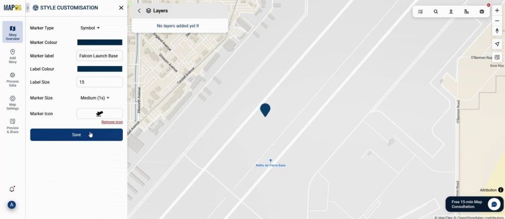
4. Customize Your Point Visualization
Now, under the Point Customization tab, carefully select a suitable icon that aligns with military or airbase visualization. Choose a clear label, and additionally, adjust the color coding to accurately represent different airbase types. Save these customization settings to ensure consistency across your map.
5. Add Additional Flight Path Points
Repeat the process for other waypoints or bases. As you add each, MAPOG will auto-calculate the distance and bearing angle between points & you can easily visualize this on your map.
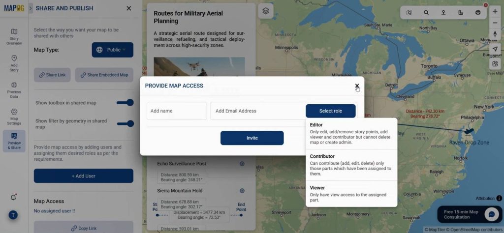
6. Preview and Share
Use the Preview and Share option in MAPOG to make the map public. Share it with your team, partners, to explore and interact with the data-rich visual.
Industry Applications & Benefits
Additionally, across sectors such as the military, disaster response, and air logistics, Mapping Military Flight Paths is especially vital. This is because accurate, GIS-based path mapping helps:
- Enhance situational awareness, especially in high-pressure environments
- Minimize route conflicts through clear visualization
- Reduce fuel consumption by optimizing bearing angles
- Ensure seamless strategic coordination between units
- Provide a reliable visual tool for operational briefings and long-term planning
What’s more, MAPOG makes all of this possible even for teams without advanced GIS expertise. Thanks to its user-friendly design, users can visually organize and analyze complex air networks using just a few simple inputs.
Conclusion
Furthermore, with strategic tools like bearing angle calculations and customizable point attributes at your disposal, platforms such as MAPOG bring advanced geospatial intelligence directly to the fingertips of military planners. In essence, if your mission involves Mapping Military Flight Paths, this streamlined method ensures not only high accuracy but also operational clarity. Ultimately, it’s more than just plotting a route—it’s about making data-backed decisions for safer, more secure skies.