Whether you’re a real estate agent, property manager, or investor, mapping rental properties with key nearby amenities gives your listings the edge. In fact, visual maps offer clarity, transparency, and better decision-making for both renters and owners. By combining precise coordinates with contextual data—such as distance from schools, hospitals, or parks—you ultimately make the rental experience more informed and engaging. Additionally, MAPOG even allows you to create interactive story maps to seamlessly visualize properties and their surroundings.
Understanding the Key Concept: Mapping Rental Properties
At its core, mapping rental properties involves placing your real estate data—locations, property details, and nearby facilities—onto a visual GIS-based map. As a result, this not only enhances transparency but also improves accessibility for those viewing the listings. Furthermore, using platforms with “add story” and “preview and share” capabilities makes this process easier, especially when you’re managing multiple listings.
Step-by-Step Guide to Mapping Rental Properties on an Interactive Map
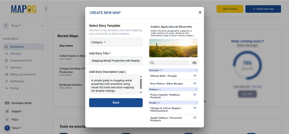
1. Start with a Fresh Canvas
Open MAPOG, click on “Create New Map”, and choose Category as your story template. Give your map a clear title and short description then save it.
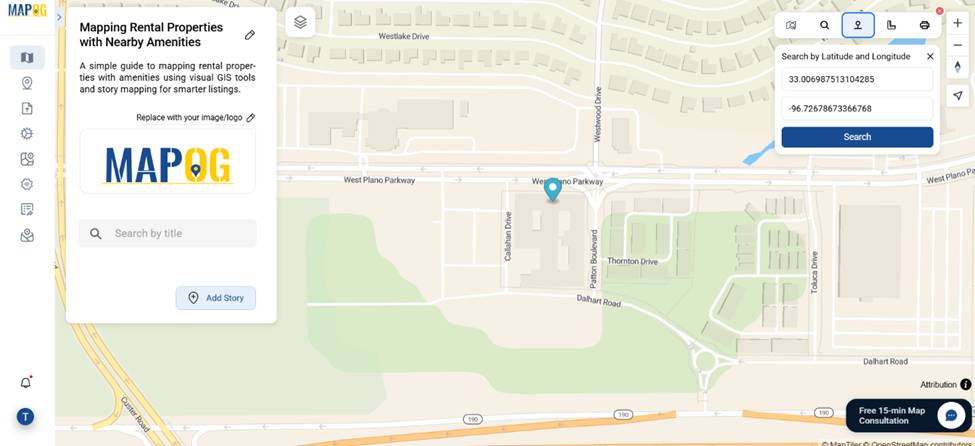
2. Plot Your Property by Coordinates
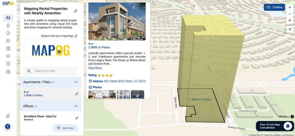
Go to the toolbox and select the latitude & longitude tool. Input the precise coordinates of your property. This ensures accuracy and helps later when measuring distances to amenities.
3. Define the Property Area
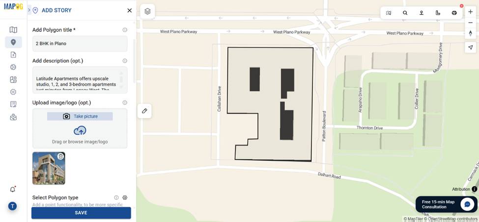
Click on Add Story → Add Manually and use a draw polygon to draw the boundary around your rental property. This makes it stand out on the map.
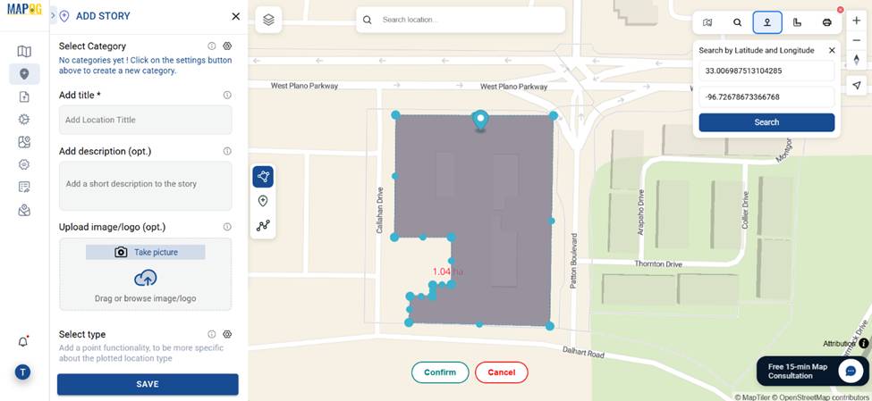
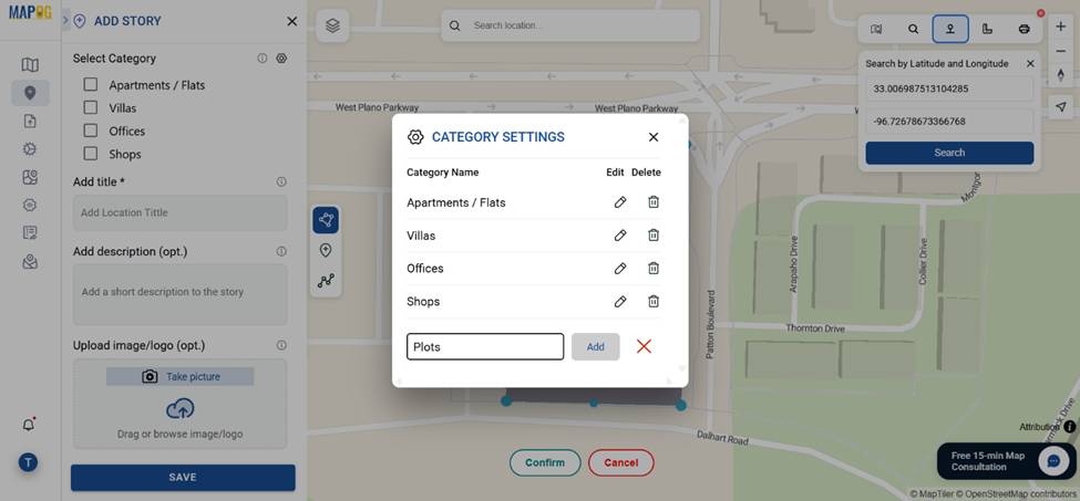
4. Categorize Your Properties
In the settings section of Select category, create categories like Apartment, Studio, and Villa and many more. Tag each property accordingly.
add relevant details—title, description, and images.
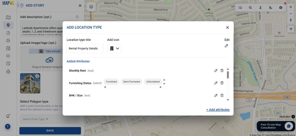
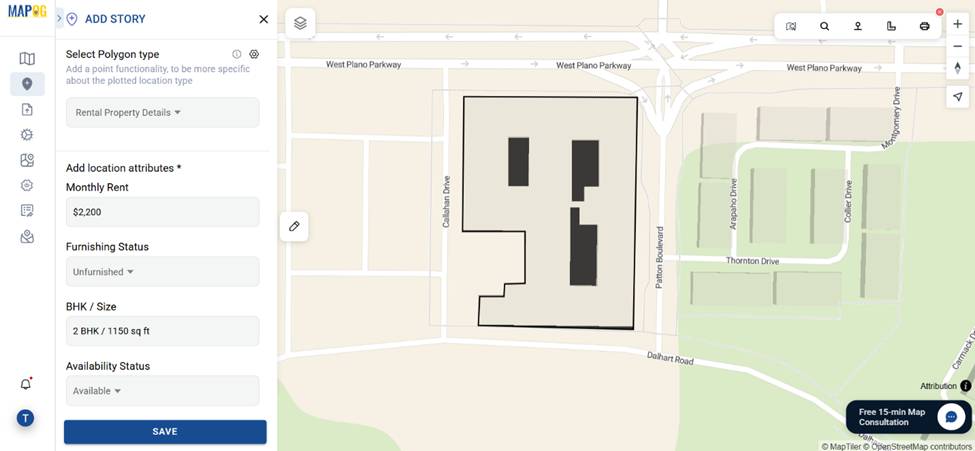
5. Add Property Details as Attributes
Go to the select polygon type settings and open “Location Type Management”. Add a new location type named “Rental Property Details”. Include attributes like: Property ID, Monthly Rent, BHK Size etc.
Fill these out and save. This structure improves searchability.
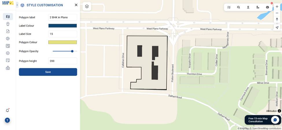
6. Customize Visual Appearance
Adjust point styles—label, height, size, and color—to make each rental stand out. These visual cues help distinguish between categories at a glance.
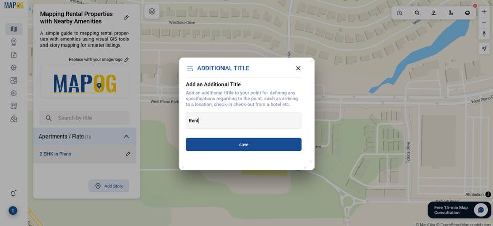
By clicking the “Additional Titles” option we can set the properties as “Rent, Buy or Lease”.
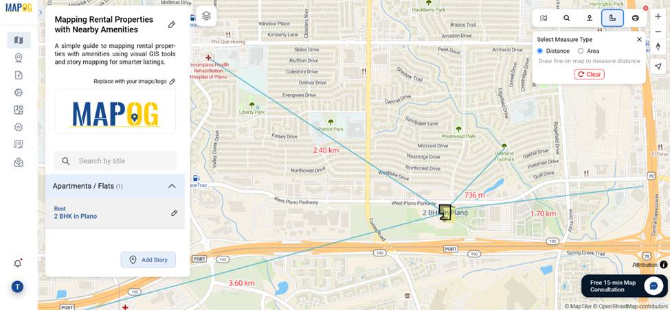
7. Measure Distance to Amenities
Use the Measure Tool to calculate the exact distance from the property to key locations like hospitals, parks, and schools. This gives potential tenants essential proximity info.
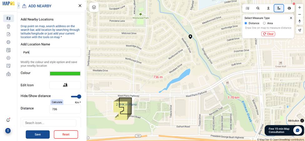
8. Add Nearby Amenities as Markers
Additionally, use the Add Nearby Points feature to place markers for amenities such as schools, hospitals, petrol pumps, parks, and grocery stores. To enhance clarity, show distances and use distinct icons and colors to make each amenity easily identifiable.
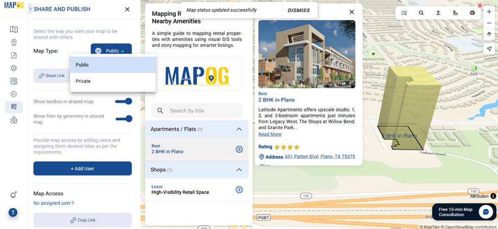
9. Finalize and Share
Once your map is ready, click “Preview and Share” to publish it. You can set it to public so it’s accessible via a shareable link. Alternatively, share it privately using role-based access — viewer, contributor, or editor — depending on how much control you want others to have. As a result, the map becomes useful not only for renters and agents but also for embedding directly on your website
Industry Relevance & Benefits of Mapping Rental Properties
- Faster Decisions: Renters can quickly visualize all essentials at a glance; moreover, this saves time and reduces uncertainty.
- Competitive Edge: Listings with spatial context tend to perform better in crowded rental markets; in fact, they attract more attention and trust.
- Scalability: You can easily update multiple units with consistent formats; therefore, managing changes becomes more efficient as your portfolio grows.
Conclusion
Ultimately, mapping rental properties isn’t just about pins on a map—it’s about creating context. Whether you’re listing a single apartment or an entire portfolio of villas, combining property data with nearby amenities gradually transforms your map into a powerful rental tool. Fortunately, MAPOG helps you do this with clarity—allowing you to organize, visualize, and share rentals more efficiently.